Tactical NAV
MGRS Navigation for Military
#1 Keyword Rankings
Today
Top 10 Rankings
Today
Top 30 Rankings
Today
Top 100 Rankings
Today

Description

BACKGROUND:

Built from the ground up in the rugged mountains of eastern Afghanistan, Tactical NAV was created by a U.S. Army Field Artillery officer with the vision of crafting a low-cost and highly accurate mobile navigation platform tailored for the U.S. military.

Tactical NAV's journey began in the Pech River Valley and the Korengal Valley in Kunar Province, Afghanistan.

U.S. Army Capt. Jonathan J. Springer, a Fire Support Officer with the 101st Airborne Division (Air Assault), embarked on the development of this tactical navigation platform immediately following the memorial services for Spc. Blair D. Thompson and Spc. Jared C. Plunk, who were killed in action on June 25, 2010.

Despite initial rejections by the Department of Defense, Captain Springer remained steadfast in his mission to continue developing Tactical NAV — even to this day. His ultimate goals were (and still are) to make a positive difference for other soldiers and service members and to honor the men and women killed and wounded in battle.

He used his life savings to fund and develop Tactical NAV, all with the ultimate hope of saving military lives and assisting fellow service members in accomplishing their missions at home and abroad.

Tactical NAV officially launched on the App Store on February 14, 2011.

BUILT FOR ACCURACY:

Tactical NAV's performance accurately matches that of the AN/PSN-13 Defense Advanced GPS Receiver (DAGR).

MISSION:

Empower military service members with a highly accurate and powerful mobile navigation platform.

VISION:

Assist and support our nation's service members with their mobile navigational needs and enable them to operate and win in both training and combat environments.

BOTTOM LINE:

Tactical NAV has successfully undergone evaluation against other software platforms and devices such as Nett Warrior, ATAK, and BFT. Its accuracy is within 1 meter of these officially approved systems issued by the DoD.

IAPs & SUBSCRIPTIONS:

Tactical NAV offers in-app purchases (IAPs) and subscriptions. Currently, tactical drawing mode is available as an in-app purchase, and offline mapping mode is also accessible to users as either a monthly or yearly subscription.

All revenue generated from these features contributes to further developmental coding and updates, and a portion of the proceeds are donated to charities that specifically benefit disabled veterans.

KEY FEATURES:

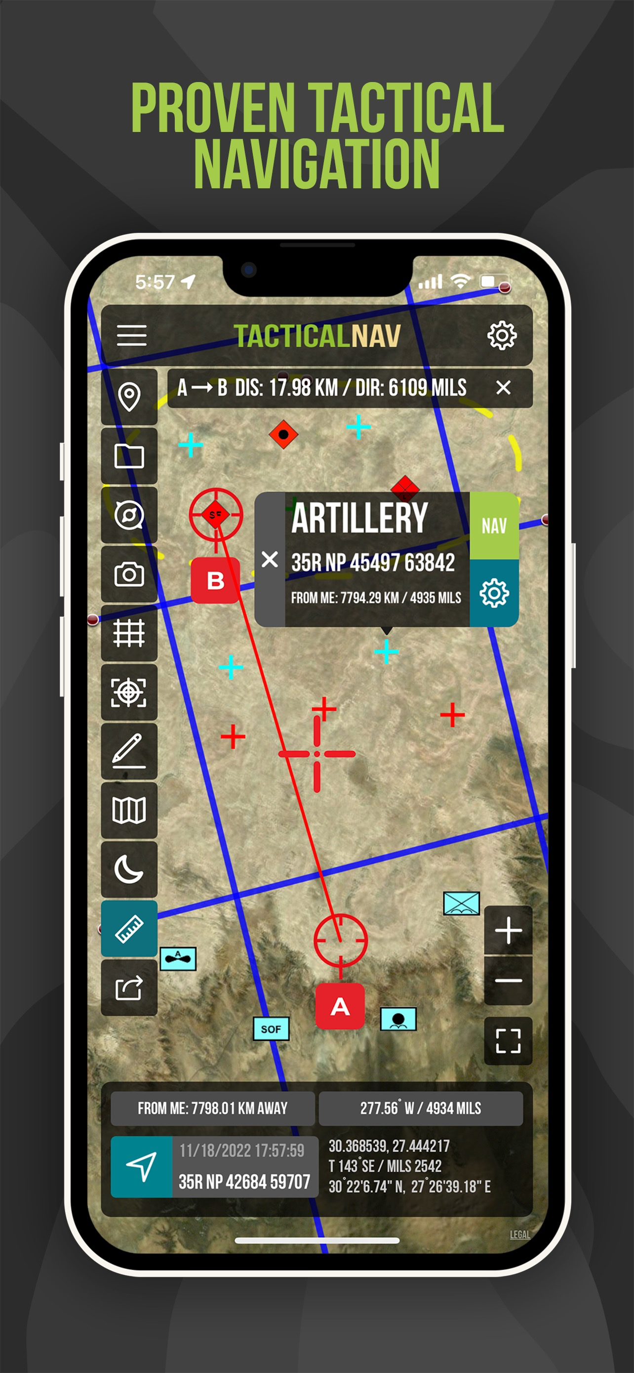
• A military-quality precision targeting platform
• Purpose-built for the individual soldier
• Offline mapping capabilities (complete usage of the app with no emission of a cellular signal)
• WGS-84 standard (MGRS, UTM, BNG, and USNG coordinates)
• Tactical drawing mode (useful for mission planning, building overlays, targeting, etc.)
• Waypoint plotting functionality with military graphics (per FM 1-02.2)
• Compass "FastLock" function for capturing quick and precise azimuths
• Snap and save photographs onto the main map to increase situational awareness
• Location, waypoint, and photo-sharing capabilities (via email and text)
• One-button night mode function for low-light situations
• 'Go to Grid' feature for precision planning, drawing of overlays, and dropping waypoints
• Rigorously tested to ensure utmost accuracy and reliability
• iOS/iPadOS native code built for austere and contested environments

IMPORTANT NOTES:

The Department of Defense does not endorse Tactical NAV, nor should it be used in life-threatening or combat situations in place of a government-issued device.

OFFLINE MAPS TUTORIAL:

Learn more about offline maps and other features through our YouTube tutorial. Follow this link to view the video walkthrough: https://bit.ly/Offline-Maps

SUPPORT:

If you have any questions about the app, please contact Jonathan Springer directly at [email protected].
Hide.. Show more..

In-Apps

Drawing Mode
£4.99
Offline mapping for 1 year
£19.99
Offline mapping for 1 month
£9.99
Offline mapping for 3 months
£6.99
Offline mapping for life time
£39.99

Screenshots

User Rating

4.25 out of 5

4 ratings in United Kingdom

5 star
2
4 star
1
3 star
1
2 star
0
1 star
0

Ratings History

Reviews

Brilliant

Ranger5430 on

So I work as part of an Armed Protection Team on an oil field in the Middle East. This app has been an absolute asset for me plotting locations and being able to identify suitable tracks for routes I need to use in order to get to various locations. I have recommended this to so many people on my contract use. You can plot grids in all different formats from Lat & Long, degrees, UTM and MGRS. I honestly can’t recommend this enough. It also comes with a variety of pins for markers including NATO map symbols.

Good app, slight bug.

Drawnothing...... on

Been using this app for a while now. Very clever app on the whole. Lots of useful functions. Slight bug I’ve noticed is that the BNG function has stopped working and it seems to be stuck on MGRS.

Good concept but flawed

Sarrie25 on

As being an ex-squaddie I'm still attracted to things green and shiny and thought this App would be great for walking, has some good features ie being able to label a Picture with a Date,time and grid and from a military point of view being able to identify a grid from a sat nav image quickly but as with a lot of these navigation apps it's let down by poor mapping, very basic , no features or tracks just roads , would be great if it had an O/S type overlay , in a nut she'll not great for navigation unless you don't mind working from a satalite image, but a still a handy tool

Update not working

Blobface978 on

Just completed the update and the main function does not work. The map remains frozen. Congrats on the fixing of the 'bugs', it worked a treat!

Impressive

Andrew Brocklehurst on

Great app when used in conjunction with the limited paper mapping available out here. Would be perfect if there was a way to incorporate offline google mapping.

Overrated

Slyatslys on

Overrated, over priced and crashes a lot, quite unstable and definitely not robust enough to be "military grade" - the waypoints need to be in MGRS and that is the only option ... Not great if using OS refs in the UK or latitude and longitude - it needs to be able to auto recognise and convert other coordinate systems which should be quite easy. It would help if it took lat and long at the very least. Very small icons are difficult to use and not obvious meaning in all cases. Latest update seems no better than previous versions tbh! :-( 10/10 for hype , 1/10 for result!

No.

Fabwood on

Not worth your £3.49. Pointless app which no-one needs to use!

Tactical Nav

CarrotJuice2 on

Great App. If the DoD can't fund this initiative then us App fans can contribute. A small price to pay in support of our brave war fighters.

Does what it says it will

Gearymeister on

Good app works well

For the heroes

Tommyk555 on

To help those in the wars of this world...

Store Rankings

Ranking History

App Ranking History not available yet

Category Rankings

Chart
Category
Rank
Top Paid
10
Top Paid
11
Top Paid
20
Top Paid
22
Top Paid
24

Keywords

Users may also like

Name
Theodolite
AR Navigation Viewfinder
Mgrs & Utm Map
CalTopo
Backcountry mapping evolved
Military GPS Survival Kit
MGRS SAR Tactical Navigation
iTAK
Team Awareness Kit
Sit(x)
SA Solution for any Situation
CWTSato To Go
TravelWifi
The Next Dimension of Travel.
GuideOn Military
TAK Tracker
Lightweight tracking for TAK
Show More

Revenue and Downloads

Gain valuable insights into Tactical NAV performance with our analytics. Sign up now to access downloads, revenue, and more.

App Info

Category
Navigation
Publisher
TacNav Systems LLC
Languages
English
Recent version
4.2.2 (1 month ago )
Released on
Feb 14, 2011 (13 years ago )
Last updated
2 weeks ago