Measure the elevation of each location within a radius of 500 meter. With Terrain Radar Altimeter you can discover the height of hills in front of you or take a look at further away mountains. The unique combination of device sensors and internet-based geo informations makes Terrain Radar to the best altimeter app in the store.
FEATURES:
• High accuracy digital elevation model
• Range up to 500 meter (1600 ft)
• Calculation of altitudes in real time
• Precise elevation chart
• Display in meter or feet
The altitudes are calculated through online services, based on your GPS position and compass direction.
Whether biking, hiking or walking - with this altimeter app every trip is a journey of discovery!
Hide..Show more..
In-Apps
Long-Range Radar
$3.99
Screenshots
User Rating
4.7 out of 5
556 ratings
in United States
5 star
457
4 star
62
3 star
17
2 star
11
1 star
9
Ratings History
Reviews
👍🏾a couple of suggestions 🧭🎨
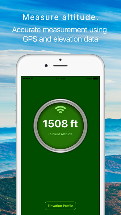
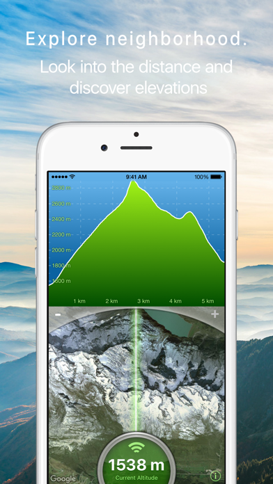
🏔️🗺️ this app is simple but clever. I'm hoping it's going to help me with the drone I'm about to buy. It's just fun otherwise.
I think it needs a compass. This shouldn't be too tough to add. Also the color scheme 🟦🟩 for the elevation is pretty…garish -- maybe you could eventually give some user options.
Best one so far
Great for finding a high point in your area
My paid for app disappeared
I’m happy to pay for good products
I paid for the upgraded version of this app
The developer literally removed it, changed the name of the version which literally does nothing new now I am required to pay again
Please do not support developers that use this kind of business practice
I would have communicated with customer support directly but as you might imagine there is no means to contact this developer. I don’t blame him for hiding from any response to this scheme.
Lifesaver
I used this app to find out the highest ground closest to me that I could evacuate to. That was above the expected flood height when the Oroville Dam spillway incident/failure occurred.
Radar Daddy
Gotta have that radar thing all the time. Great service and platform.
Great app
I us this app in my walking on the ridges and valleys it gives a accurate reading.
Discussed
I’m in the woods and want to know what elevation it is. It says no internet. Yes you idiots I know the elevation where I live. I want the elevation of the mountain I happen to be on.
Almost great, BUT.
Would I buy this app again ... probably. Because it has what may be a distinct feature in it: you point your iPhone in any direction and it shows satellite view of what’s ahead (up to 17k feet with $1.99 upgrade).
BUT it has two missing things to wish for:
= You can’t zoom in close enough to clearly recognize things. There is an intersection about 500 ft from my house and I could not clearly identify it.
= There are no road names so its even harder to identify locations you see in the satellite view. It needs a hybrid view.
If the developer added these two abilities my opinion of the app would go from OK to Great.
Pilot
Works for me
Enjoy while Climbing
Have use this application on every climb I've been on in the past six months. Has come in handy several times.