The Argis® Lens
Augmented Reality for GIS
#1 Keyword Rankings
Today
Top 10 Rankings
Today
Top 30 Rankings
Today
Top 100 Rankings
Today
Description
The Argis® Lens helps field operators overcome the limitations of two-dimensional mapping technology when working with underground assets. This app brings ArcGIS data into the three-dimensional world they work in—creating a seamless user experience. End users can locate underground assets more quickly with improved situational awareness, record discrepancies between their current GIS data and known underground facilities for correction, and benefit from an overall increase in productivity in the field while improving GIS data over time.
Key Features of the Argis® Lens:
• The only patented integration of augmented reality with ESRI's ArcGIS platform registered in the U.S.
• Advanced integration is available with Workforce for ArcGIS and other ESRI mobile applications for improved field mobility.
• It is as accurate as the GPS unit used, either with the GPS hardware internal to the device or other Bluetooth GPS options.
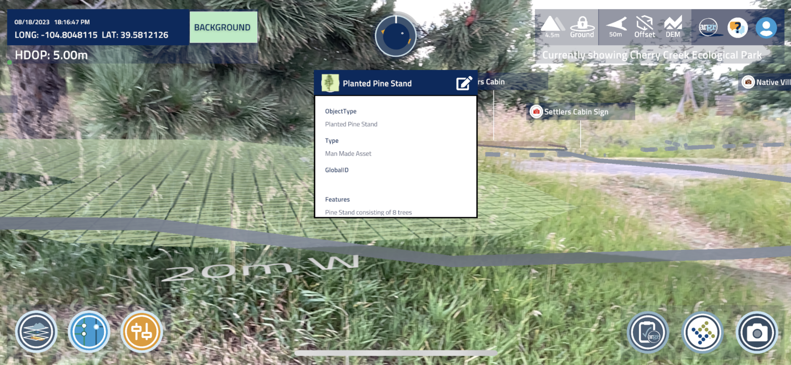
• View ArcGIS online feature services in real time as augmented reality, stable and locked to the ground.
• Edit feature objects within the AR view to update object attributes from the field.
• Cache scenes to the device to work offline or in remote locations.
• No additional hardware is needed to use The Argis Lens.
• Translate ArcGIS data directly in real time using the same color legend and symbology shown in the feature services.
Patented and proven, the Lens is the easiest, most direct way to integrate augmented reality with any ArcGIS implementation.
Hide..
Show more..
Key Features of the Argis® Lens:
• The only patented integration of augmented reality with ESRI's ArcGIS platform registered in the U.S.
• Advanced integration is available with Workforce for ArcGIS and other ESRI mobile applications for improved field mobility.
• It is as accurate as the GPS unit used, either with the GPS hardware internal to the device or other Bluetooth GPS options.
• View ArcGIS online feature services in real time as augmented reality, stable and locked to the ground.
• Edit feature objects within the AR view to update object attributes from the field.
• Cache scenes to the device to work offline or in remote locations.
• No additional hardware is needed to use The Argis Lens.
• Translate ArcGIS data directly in real time using the same color legend and symbology shown in the feature services.
Patented and proven, the Lens is the easiest, most direct way to integrate augmented reality with any ArcGIS implementation.
Screenshots


 User Rating
0 out of 5
0 ratings in Portugal
Ratings History
Reviews
App doesn't have any reviews yet
Store Rankings
Ranking History
App Ranking History not available yet
Category Rankings
App is not ranked yet
Keywords
Users may also like
| Name | Reviews | Recent release | |
|---|---|---|---|

vGIS AR
Augmented reality for GIS
|
0
|
3 weeks ago | |

Augview
AR for Asset Management
|
0
|
9 months ago | |

Esri Support
|
0
|
1 week ago | |

ArcGIS Indoors for Intune
|
0
|
7 months ago | |

FieldMap Pro
|
0
|
1 month ago | |

vGIS HoloLens Bridge
Bridge for Hololens
|
0
|
1 year ago | |

ArcGIS Responder 10.9.1
|
0
|
2 years ago | |

HiperGIS
Your GIS powered by Hiperweb
|
0
|
8 months ago | |
ArcGIS Responder 11
|
0
|
1 year ago | |

vGIS Scan
A LiDAR scanner from vGIS
|
0
|
1 month ago |
Show More
Revenue and Downloads
Gain valuable insights into The Argis® Lens performance with our analytics. Sign up now
to
access downloads, revenue, and more.
App Info
- Category
- Productivity
- Publisher
- Argis Technologies, LLC
- Languages
- English
- Recent version
- 3.1.4.2 (11 months ago )
- Released on
- Nov 2, 2020 (3 years ago )
- Also available in
- United States, Philippines, Israel, India, Italy, Japan, South Korea, Mexico, Malaysia, Netherlands, Norway, New Zealand, Peru, Ireland, Poland, Portugal, Romania, Russia, Sweden, Singapore, Thailand, Taiwan, Ukraine, South Africa, Denmark, Austria, Australia, Belgium, Brazil, Belarus, Canada, Switzerland, Chile, Colombia, Czechia, Germany, Argentina, Dominican Republic, Ecuador, Egypt, Spain, Finland, France, United Kingdom, Greece, Hong Kong, Hungary, Indonesia
- Last updated
- 2 months ago