Description
* View over 70,000 USGS and Canadian topographical maps on your iPhone or iPod touch. * Ideal for hiking and other backcountry activities. * Map downloads are FREE! * More than 16 million maps downloaded so far!
- iPad owners, please see the app "Topo Maps for iPad".
* Users write:
" I've bought all the topo map apps and I like this the best "
" Scans are gorgeous ... the interface is exceptionally clean "
" Downloading maps is easy and fast ... Map displays beautifully and zooms flawlessly "
* Includes Alaska (at 1:24,000 and 1:63,360) and Canada (at 1:50,000), plus Hawaii, Puerto Rico and the U.S. Virgin Islands.
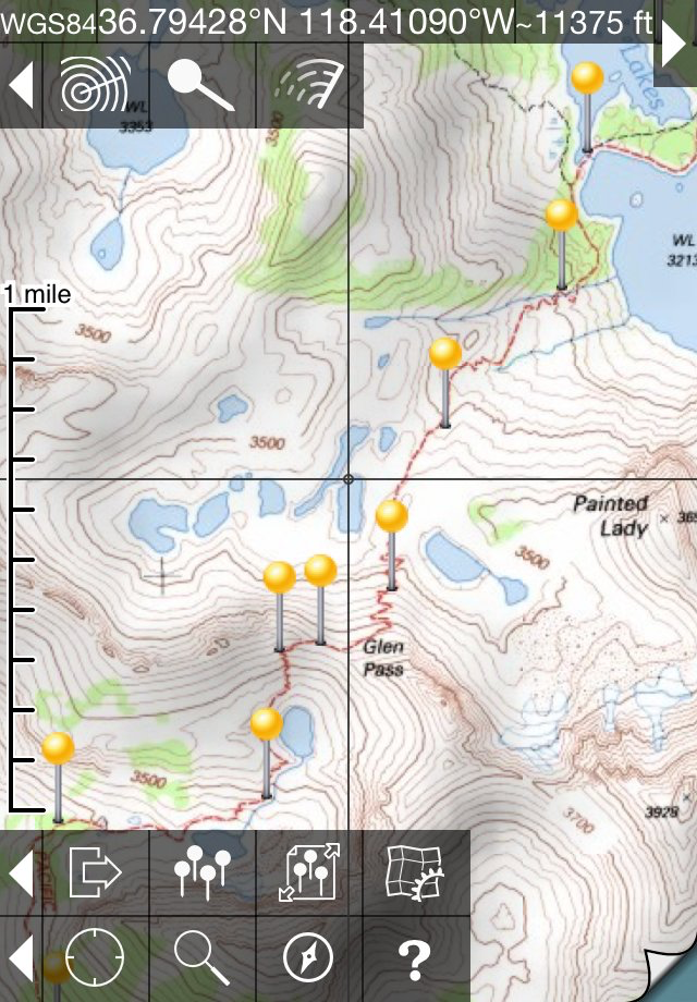
* Locate the maps you need on the satellite view. To install a map, touch for about half a second. Touch again to view it.
* Search by name for over a million towns, peaks, lakes, parks and other features.
* No network connection is needed once the maps have been installed.
* Mark waypoints, and import and export waypoint files in GPX, KML and CSV formats.
* Touch the "current location" button to see where you are, and the compass button to align the map with the ground.
* See coordinates in NAD27 or WGS84 degrees, degrees minutes and seconds, UTM, or MGRS formats.
* Measure distances (miles, feet and km) and bearings (true and magnetic).
Coverage: this app makes available more than 70,000 maps covering the United States, including Alaska, Hawaii, Puerto Rico and the U.S. Virgin Islands, and Canada.
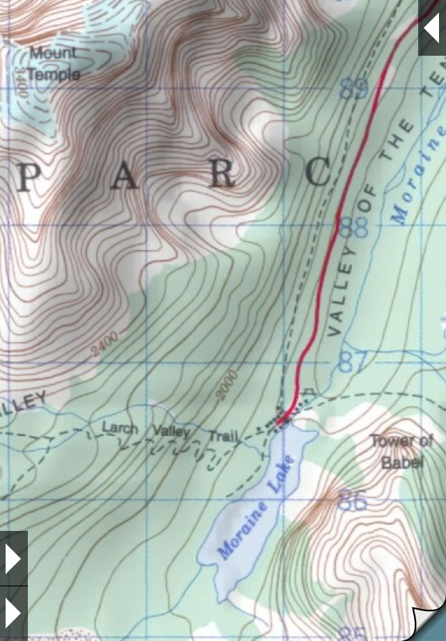
The Maps: This app uses high-quality scans of the traditional USGS and NRCan topographic maps which have been the definitive resource for hikers and other backcountry users for many years. You can make the terrain stand out with hill shading, using simulated sunlight from the direction of your choice. This app does not use the new "US Topo" maps because they do not show hiking trails and lack other details: please see the web site for more details.
Downloading: US maps are around 8 MB in size and download in a few seconds on a typical home broadband connection. Canadian maps are larger. Both cellular data and WiFi can be used, though WiFi is likely to be more reliable in most cases.
- Do please visit https://topomapsapp.com/ for complete instructions, so that you don't miss any features.
We have many ideas for additional features to add to future versions of this app; if you have ideas or other questions or comments, contact details can be found on the website, https://topomapsapp.com/. The website also has more screenshots and other information.
Hide..
Show more..
- iPad owners, please see the app "Topo Maps for iPad".
* Users write:
" I've bought all the topo map apps and I like this the best "
" Scans are gorgeous ... the interface is exceptionally clean "
" Downloading maps is easy and fast ... Map displays beautifully and zooms flawlessly "
* Includes Alaska (at 1:24,000 and 1:63,360) and Canada (at 1:50,000), plus Hawaii, Puerto Rico and the U.S. Virgin Islands.
* Locate the maps you need on the satellite view. To install a map, touch for about half a second. Touch again to view it.
* Search by name for over a million towns, peaks, lakes, parks and other features.
* No network connection is needed once the maps have been installed.
* Mark waypoints, and import and export waypoint files in GPX, KML and CSV formats.
* Touch the "current location" button to see where you are, and the compass button to align the map with the ground.
* See coordinates in NAD27 or WGS84 degrees, degrees minutes and seconds, UTM, or MGRS formats.
* Measure distances (miles, feet and km) and bearings (true and magnetic).
Coverage: this app makes available more than 70,000 maps covering the United States, including Alaska, Hawaii, Puerto Rico and the U.S. Virgin Islands, and Canada.
The Maps: This app uses high-quality scans of the traditional USGS and NRCan topographic maps which have been the definitive resource for hikers and other backcountry users for many years. You can make the terrain stand out with hill shading, using simulated sunlight from the direction of your choice. This app does not use the new "US Topo" maps because they do not show hiking trails and lack other details: please see the web site for more details.
Downloading: US maps are around 8 MB in size and download in a few seconds on a typical home broadband connection. Canadian maps are larger. Both cellular data and WiFi can be used, though WiFi is likely to be more reliable in most cases.
- Do please visit https://topomapsapp.com/ for complete instructions, so that you don't miss any features.
We have many ideas for additional features to add to future versions of this app; if you have ideas or other questions or comments, contact details can be found on the website, https://topomapsapp.com/. The website also has more screenshots and other information.
Screenshots


User Rating
App is not rated in Dominican Republic yet.
Ratings History
Topo Maps Installs
Last 30 days
Topo Maps Revenue
Last 30 daysTopo Maps Reviews
No Reviews in Dominican Republic
App doesn't have any reviews in Dominican Republic yet.
Store Rankings
Ranking History
App Ranking History not available yet
Category Rankings
|
Chart
|
Category
|
Rank
|
|---|---|---|
|
Top Paid
|

|
43
|
|
Top Paid
|

|
52
|
|
Top Paid
|

|
56
|
|
Top Paid
|

|
66
|
|
Top Grossing
|
|
96
|
Keywords
Topo Maps Competitors
| Name | Reviews | Recent release | |
|---|---|---|---|
Maps 3D PRO - Outdoor GPS
GPS para ciclismo y senderismo
|
0
|
4 months ago | |

MapOut
Beautiful hiking & cycling map
|
0
|
9 months ago | |

Topo GPS - Topographic maps
Mapas topograficos
|
0
|
1 week ago | |

Topo Maps+
Offline Topographic Maps & GPS
|
0
|
1 day ago | |

Terra Map - Trail Explorer
Mapa topo: caminos y rutas
|
0
|
1 month ago | |

Gaia GPS Mapas Topo, Senderos
App • Senderismo, Bici, 4x4
|
0
|
1 week ago | |

FATMAP: Esquí, Trek, Ciclismo
Mapas 3D y Guía Outdoor
|
0
|
3 months ago | |

boonmaps
Offline 3D Adventure Maps
|
0
|
3 years ago | |

Altimeter for Aviators
Pure Pressure Altimeter
|
0
|
4 months ago | |

Idaho 511
|
0
|
6 months ago |
Topo Maps Revenue and Downloads
Gain valuable insights into Topo Maps performance with our analytics.
Sign up now to access downloads, revenue, and more.
Sign up now to access downloads, revenue, and more.
App Info
- Category
- Navigation
- Publisher
- Mappendix
- Languages
- English
- Recent version
- 1.19 (1 year ago )
- Released on
- Mar 27, 2009 (15 years ago )
- Also available in
- United States, Canada, Israel, France, Spain, United Kingdom, Greece, New Zealand, Russia, Germany, Switzerland, Italy, Japan, Australia, Mexico, Nigeria, Netherlands, Norway, Malaysia, Peru, Lebanon, Poland, Philippines, Pakistan, India, Portugal, Romania, Saudi Arabia, Sweden, Singapore, Thailand, Turkey, Taiwan, Ukraine, Vietnam, South Africa, Dominican Republic, Argentina, Austria, Azerbaijan, Belgium, Brazil, Belarus, Chile, China, Colombia, Czechia, Denmark, Kazakhstan, Algeria, Ecuador, Egypt, Finland, Hong Kong, Hungary, Indonesia, Ireland, United Arab Emirates, South Korea, Kuwait
- Last updated
- 3 days ago