
Toward
shows distance and direction
#1 Keyword Rankings
Today
Top 10 Rankings
Today
Top 30 Rankings
Today
Top 100 Rankings
Today
Description
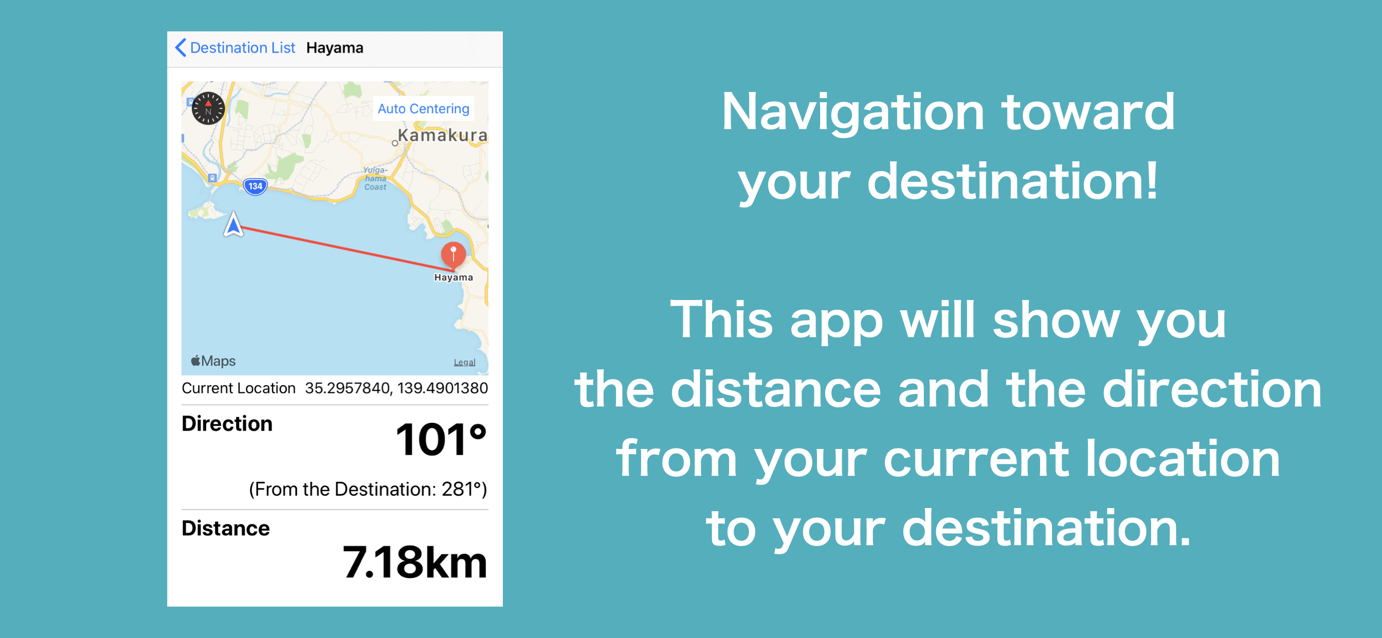
Navigation toward your destination!
This app will show you the distance to your destination and in which direction from your current location.
It can also be used in airplane mode, so it works on planes and ships.
There are no ads.
The UI is designed to be large enough to be used on the sea and easy to operate even your device is in a case.
The simple design makes it easy to recognize the information at a glance.
How to use:
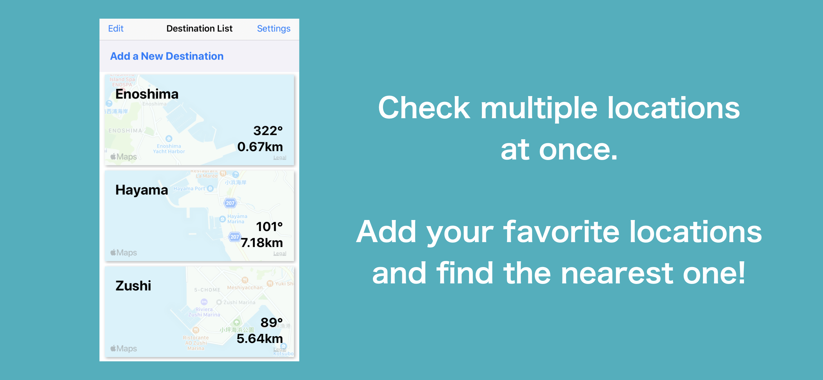
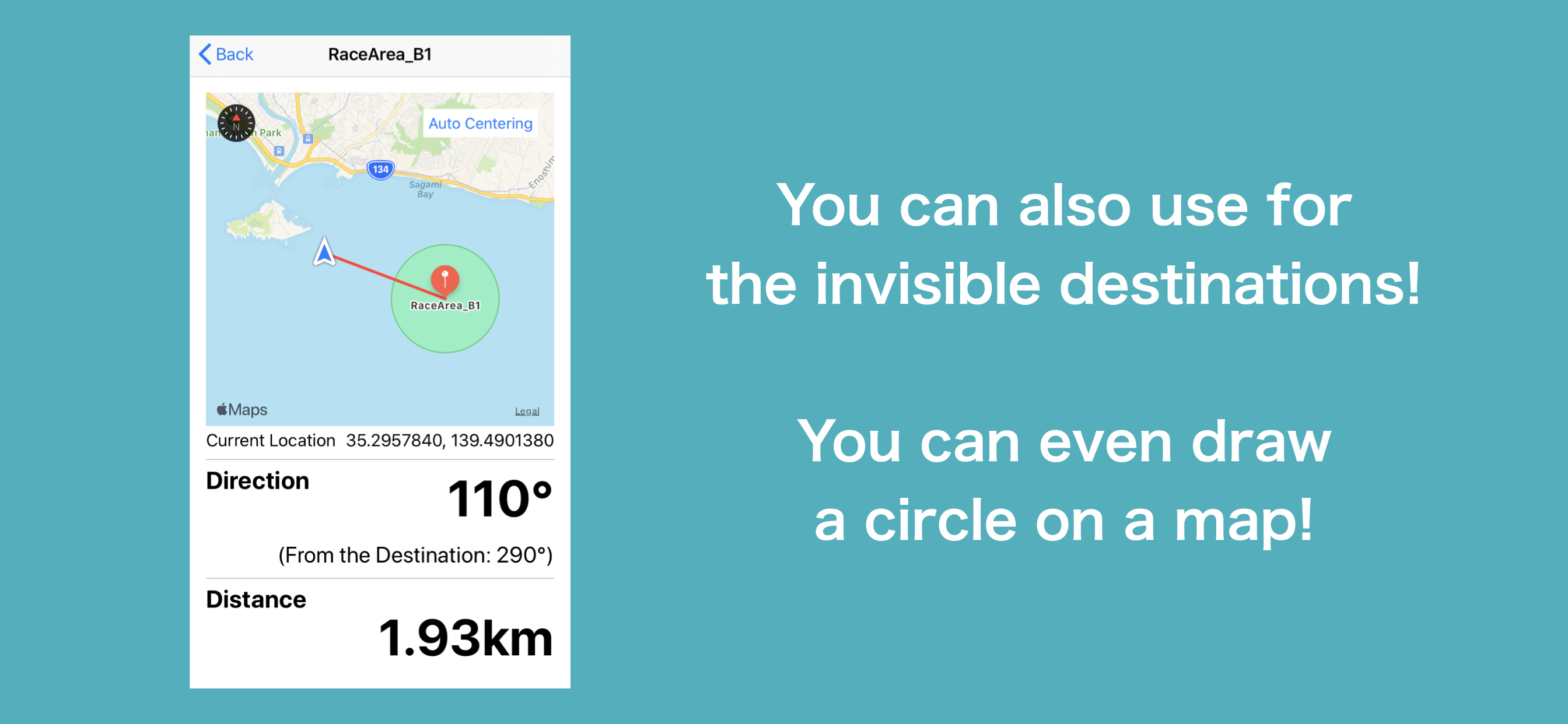
1. Set your destination from the map or latitude and longitude! (For the example, the data of "Enoshima" is set.)
2. On the list page, you can see the locations that you have added so far. Let's find out where the closest one is to your current location!
3. Tap the destination on the list to start the navigation. (Please check the actual surroundings and follow the traffic rules strictly)
4. By tapping the Edit button, you can sort, delete, and re-edit the destination.
5. The setting page allows you to change various units.
Note:
- Since this application works with GPS, you cannot use this in tunnel or underground environments.
- Do not operate this application while driving, because it is dangerous.
- The straight line is not correct because the map is drawn by Mercator method. Please note that the more distant the destination, the greater the error will be.
- Application developer is not responsible for any disadvantages such as accidents and injuries while using this application. Please be sure to use this at your own risk.
Hide..
Show more..
This app will show you the distance to your destination and in which direction from your current location.
It can also be used in airplane mode, so it works on planes and ships.
There are no ads.
The UI is designed to be large enough to be used on the sea and easy to operate even your device is in a case.
The simple design makes it easy to recognize the information at a glance.
How to use:
1. Set your destination from the map or latitude and longitude! (For the example, the data of "Enoshima" is set.)
2. On the list page, you can see the locations that you have added so far. Let's find out where the closest one is to your current location!
3. Tap the destination on the list to start the navigation. (Please check the actual surroundings and follow the traffic rules strictly)
4. By tapping the Edit button, you can sort, delete, and re-edit the destination.
5. The setting page allows you to change various units.
Note:
- Since this application works with GPS, you cannot use this in tunnel or underground environments.
- Do not operate this application while driving, because it is dangerous.
- The straight line is not correct because the map is drawn by Mercator method. Please note that the more distant the destination, the greater the error will be.
- Application developer is not responsible for any disadvantages such as accidents and injuries while using this application. Please be sure to use this at your own risk.
In-Apps
- Unlock Limit of Destinations
- ₺29,99
Screenshots
 User Rating
0 out of 5
0 ratings in Turkey
Ratings History
Reviews
App doesn't have any reviews yet
Store Rankings
Ranking History
App Ranking History not available yet
Category Rankings
|
Chart
|
Category
|
Rank
|
|---|---|---|
|
Top Free
|

|
439
|
Keywords
Users may also like
| Name | Reviews | Recent release | |
|---|---|---|---|

Crowsflight
|
0
|
1 year ago | |

マイ方位
|
0
|
3 years ago | |
Arrivati
Basit harita navigasyonu
|
0
|
9 months ago | |

Aisea PRO - アイシア
船舶の業務をサポートし、安全性を向上します
|
0
|
5 months ago | |

Aisea - Sailing support app.
For all boat operators.
|
0
|
2 years ago | |
Assist Maps
haritalara yer imi
|
0
|
2 years ago | |

How far to go?
Visualize distance in realtime
|
0
|
4 months ago | |

ピッコロマップ 〜 目的地コンパス付きの地図アプリ
歩数、カロリーの記録も出来、気ままに散歩する時にも使えます。
|
0
|
2 weeks ago | |
海の駅
|
0
|
5 months ago | |

マリンコンパス - 小型船舶やボートの安全・安心ネットワーク
|
0
|
1 week ago |
Show More
Revenue and Downloads
Gain valuable insights into Toward performance with our analytics. Sign up now
to
access downloads, revenue, and more.
App Info
- Category
- Navigation
- Publisher
- Shota Utsumi
- Languages
- English, Japanese
- Recent version
- 2.0.0 (3 years ago )
- Released on
- Jun 2, 2020 (4 years ago )
- Also available in
- Japan, United States, United Kingdom, Italy, Turkey, Thailand, Singapore, Russia, Romania, Pakistan, Philippines, Peru, Nigeria, Malaysia, Mexico, South Korea, Argentina, India, Ireland, Indonesia, Hungary, France, Spain, Egypt, China, Chile, Switzerland, Canada, Brazil, Israel, New Zealand
- Last updated
- 3 weeks ago