TURN YOUR SMARTPHONE INTO A POWERFUL NAVIGATION SYSTEM
Explore your environment with the best maps, travel the most spectacular routes, improve your performance and, above all, practice your outdoor activities in complete safety. Take your outings to a new level.
_______________________
ADAPT THE APP TO YOUR SPORT
TwoNav can be adapted to different sports, such as hiking, cycling, motor sports, flying, water sports... Create your profile and the app will adapts its configuration to this sport. Do you practice other sports? Create different profiles.
_______________________
EXPLORE YOUR SURROUNDINGS DOWN TO THE SMALLEST DETAIL
Load multiple maps at once and view them at the same time or alternately. Move the map freely to find the best perspective. Discover new points of interest near your current location.
_______________________
SAFE EXPLORATION
Follow your route and keep under control the distance, time and ascent to reach your goal. Explore routes created by you, downloaded or calculate your route automatically. The App will notify if you deviate from tour course or if you run into something unforeseen.
_______________________
SIMPLE AND INTUITIVE GPS NAVIGATION
Forget the old roadbooks on paper. Your roadbook is now digital, everything you need to know is on the screen of your smartphone. The App tells you turn by turn which road to follow.
_______________________
TRAINING TOOLS
You decide whether you train by time, by distance... or compete against yourself with TrackAttack™. Improve your performance from a previous training session. The app tells you whether you exceed your previous performance or whether you need to improve.
_______________________
CREATE YOUR OWN ROUTES AND WAYPOINTS
Create routes and waypoints by pressing directly on the screen, organize them in folders and collections. You can also enrich your references by adding photos and videos.
_______________________
3D VIEW FOR MORE REALISM
Just before you leave home, turn your 2D maps into a 3D view. Plan the difficulty of the terrain you will be entering to with a very realistic simulation.
_______________________
OPTIMIZE YOUR PERFORMANCE
Monitor the most relevant data of your activity such as distances, speed, times and altitudes. The App will show data for what you have covered so far and what is still ahead of you.
_______________________
VISIBLE AND AUDIBLE ALARMS
Set how far you want to go, set alarms, the app will warn you if you exceed the limits you have set (heart rate, speed, altitude, route deviation...).
_______________________
BROADCAST YOUR LOCATION LIVE
With Amigos™ you will be able to share your location live wherever you are. This ensures your safety and that of your loved ones.
_______________________
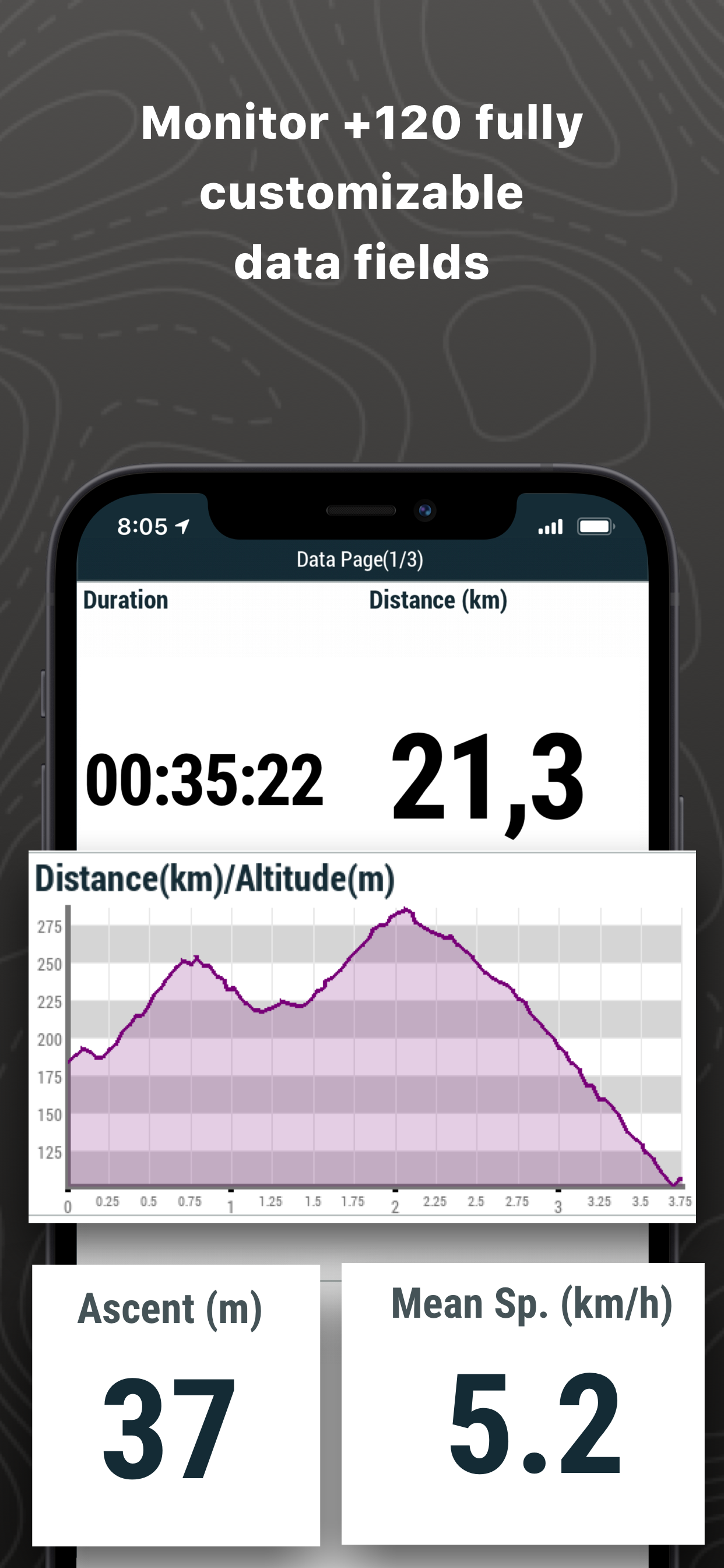
DETAILED ANALYSIS OF YOUR ROUTES
Back at home, analyze your routes with detail and accuracy. Relive every stage of your adventure with graphs, laps, +120 data fields...
_______________________
CONNECT WITH THE WORLD
Keep your activities in a safe and accessible place thanks to the GO Cloud (30 MB free). Connect to other services such as Strava, TrainingPeaks, Komoot, UtagawaVTT or OpenRunner, synchronize your activities or download your best routes.
_______________________
IMPORTANT
The acquisition of this App through iTunes does not allow installation on other devices different that iOS operating systems.
Hide..Show more..
In-Apps
OSM Japan
19,99 zł
OSM Spain
19,99 zł
OSM Poland
19,99 zł
OSM Sweden
19,99 zł
OSM Turkey
19,99 zł
OSM Germany
19,99 zł
OSM Portugal
19,99 zł
OSM Italic Peninsula & Malta
19,99 zł
OSM United States of America
19,99 zł
Alpina Travessa Ter-Freser 201
49,99 zł
Screenshots
User Rating
3.42 out of 5
12 ratings
in Poland
5 star
6
4 star
0
3 star
2
2 star
1
1 star
3
Ratings History
Reviews
Completely useless application
Completely useless application. It cannot be used after the update. My maps are not opening. This program has never been very well written. The interface was not intuitive. Now, however, it doesn't work completely. Total waste of money.
Total disaster
I have spent quite a lot of money and thought I get good topo maps of Poland as described. The maps are comparable to google maps. No touristic signs, no touristics routes. Total disaster comparing e.g to Garmin I used last few years. Dont buy this app!
Dobry Program
Jestem zadowolony, ciagle go używam!
Bardzo dobry program.
;)
Źle kalibruje polskie mapy topo
Jak w tytule. Na mapie overview pozycja jest prawidłowa. Gdy przechodzimy do map topograficznych nagle jesteśmy w zupełnie innym miejscu.
Program wydaje sie mieć duże możliwości. Ale aby go w pełni wykorzystać trzeba wydać 79€ na mapę do nawigacji drogowej. Moim zdaniem cena zbyt wysoka.