
UTM Tool
Published by:
Geomapping

Description
Die Einflüsse der UTM Abbildung können mathematisch eindeutig hergeleitet und bestimmt werden. Je nach Lage des Gebiets sind die Einflüsse der UTM Abbildung unterschiedlich groß.
Welchen Einfluss hat die UTM Abbildung auf meinen Datenbestand?
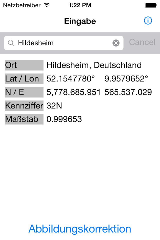
Nach Eingabe eines europäischen Ortes oder einer Postleitzahl werden die geographischen und die ETRS89/UTM Koordinaten ermittelt.
Anhand der ermittelten Werte werden die Abbildungskorrekturen der UTM Abbildung für wählbare Strecken und Flächen berechnet.
Neben den Abbildungskorrekturen der UTM Abbildung werden die Strecken- und Flächenreduktionen unter Berücksichtigung wählbarer Höhenwerte und Geoidundulation berechnet und aufgezeigt.
Hide
Show More...
Welchen Einfluss hat die UTM Abbildung auf meinen Datenbestand?
Nach Eingabe eines europäischen Ortes oder einer Postleitzahl werden die geographischen und die ETRS89/UTM Koordinaten ermittelt.
Anhand der ermittelten Werte werden die Abbildungskorrekturen der UTM Abbildung für wählbare Strecken und Flächen berechnet.
Neben den Abbildungskorrekturen der UTM Abbildung werden die Strecken- und Flächenreduktionen unter Berücksichtigung wählbarer Höhenwerte und Geoidundulation berechnet und aufgezeigt.
Screenshots
UTM Tool FAQ
-
Is UTM Tool free?
Yes, UTM Tool is completely free and it doesn't have any in-app purchases or subscriptions.
-
Is UTM Tool legit?
Not enough reviews to make a reliable assessment. The app needs more user feedback.
Thanks for the vote -
How much does UTM Tool cost?
UTM Tool is free.
-
What is UTM Tool revenue?
To get estimated revenue of UTM Tool app and other AppStore insights you can sign up to AppTail Mobile Analytics Platform.

User Rating
App is not rated in Greece yet.

Ratings History
UTM Tool Reviews
Store Rankings

Ranking History
App Ranking History not available yet

Category Rankings
App is not ranked yet
Keywords
UTM Tool Competitors
| Name | Downloads (30d) | Monthly Revenue | Reviews | Ratings | Recent release | |
|---|---|---|---|---|---|---|
|
ViGRAMsite
Amazing 3D-Modelling
|
Unlock
|
Unlock
|
0
|
|
2 years ago | |
|
JMP BattMon II
JMP BattMon II
|
Unlock
|
Unlock
|
0
|
|
2 years ago | |
|
RETTERAlarm
|
Unlock
|
Unlock
|
0
|
|
1 month ago | |
|
viDoc
|
Unlock
|
Unlock
|
0
|
|
3 months ago | |
|
Schüco BlueCon
|
Unlock
|
Unlock
|
0
|
|
4 months ago | |
|
GroupAlarm.com
Resilient app alerting
|
Unlock
|
Unlock
|
0
|
|
3 weeks ago | |
|
Rescuesheet
Schnelle Rettung
|
Unlock
|
Unlock
|
0
|
|
11 months ago | |
|
GSA
Gefahrstoffschnellauskunft
|
Unlock
|
Unlock
|
0
|
|
3 months ago | |
|
Feuerwehr Wasserförderung
Planung von Förderstrecken
|
Unlock
|
Unlock
|
0
|
|
1 year ago | |
|
Inveni
|
Unlock
|
Unlock
|
0
|
|
3 years ago |
UTM Tool Installs
Last 30 daysUTM Tool Revenue
Last 30 daysUTM Tool Revenue and Downloads
Gain valuable insights into UTM Tool performance with our analytics.
Sign up now to access downloads, revenue, and more.
Sign up now to access downloads, revenue, and more.
App Info
- Category
- Utilities
- Publisher
-
Geomapping
- Languages
- English
- Recent release
- 16.5.1 (8 years ago )
- Released on
- Jul 13, 2014 (10 years ago )
- Last Updated
- 3 weeks ago
This page includes copyrighted content from third parties, shared solely for commentary and research in accordance with fair use under applicable copyright laws. All trademarks, including product, service, and company names or logos, remain the property of their respective owners. Their use here falls under nominative fair use as outlined by trademark laws and does not suggest any affiliation with or endorsement by the trademark holders.


