
Vaarkaart Friese Meren
#1 Keyword Rankings
Today
Top 10 Rankings
Today
Top 30 Rankings
Today
Top 100 Rankings
Today
Description
The Vaarkaart Friese Meren is the perfect app for when you go sailing on the Frisian Meren.
Ideal if you have rented a boat, but also for skipper and crew of sailing boats, motor boats and sloops on the Frisian Lakes. Even if you go sailing in a canoe or kayak or go fishing on the lakes of Friesland.
This app contains the DKW Vaarkaart Frisian lakes: a very detailed water chart that covers a large part of Friesland, from Stavoren to Grou.
Navigate with this water chart on the Heegermeer, Fluessen, Morra, Oudegaster Brekken, Zwarte en Witte Brekken, Sneekermeer, Coevorden, Tjeukemeer, Langweerderwiel, and Pikmeer / Wijde Ee.
With this app you can:
- always see where you are, how fast you are sailing and what your course is with the help of a GPS (internal or bluetooth).
- place and sail to a navigation waypoint using the course line, Course to Steer and Distance to Go.
- view your sailed tracks on the chart.
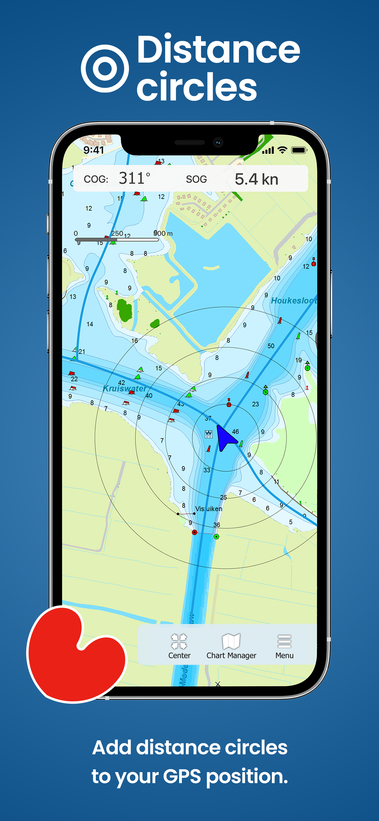
- show distance circles around your GPS position.
- Waterway network: View the information of the bridges, locks and waterways.
This is a very detailed chart with a scale of 1 m/pixel. This compares to about 1 in 3,000 on the screen. In total there are 3,393 waypoints on the DKW Vaarkaart Friese Meren, including buoys, marinas, moorings, Marrekrite berths, diesel filling stations, water sports campsites, mooring buoys, slobbers, rigging jetties and VHF channels.
With the detailed depth image from the Frisian Lakes Project in beautifully colored depth planes on the lakes and depth figures along the waterways. Developed by Stentec in collaboration with Province of Fryslân based on the most recent depth measurements.
Hide..
Show more..
Ideal if you have rented a boat, but also for skipper and crew of sailing boats, motor boats and sloops on the Frisian Lakes. Even if you go sailing in a canoe or kayak or go fishing on the lakes of Friesland.
This app contains the DKW Vaarkaart Frisian lakes: a very detailed water chart that covers a large part of Friesland, from Stavoren to Grou.
Navigate with this water chart on the Heegermeer, Fluessen, Morra, Oudegaster Brekken, Zwarte en Witte Brekken, Sneekermeer, Coevorden, Tjeukemeer, Langweerderwiel, and Pikmeer / Wijde Ee.
With this app you can:
- always see where you are, how fast you are sailing and what your course is with the help of a GPS (internal or bluetooth).
- place and sail to a navigation waypoint using the course line, Course to Steer and Distance to Go.
- view your sailed tracks on the chart.
- show distance circles around your GPS position.
- Waterway network: View the information of the bridges, locks and waterways.
This is a very detailed chart with a scale of 1 m/pixel. This compares to about 1 in 3,000 on the screen. In total there are 3,393 waypoints on the DKW Vaarkaart Friese Meren, including buoys, marinas, moorings, Marrekrite berths, diesel filling stations, water sports campsites, mooring buoys, slobbers, rigging jetties and VHF channels.
With the detailed depth image from the Frisian Lakes Project in beautifully colored depth planes on the lakes and depth figures along the waterways. Developed by Stentec in collaboration with Province of Fryslân based on the most recent depth measurements.
Screenshots


 User Rating
0 out of 5
0 ratings in Czechia
Ratings History
Reviews
App doesn't have any reviews yet
Store Rankings
Ranking History
Category Rankings
|
Chart
|
Category
|
Rank
|
|---|---|---|
|
Top Free
|

|
198
|
|
Top Free
|
|
446
|
Keywords
Users may also like
| Name | Reviews | Recent release | |
|---|---|---|---|

Waterkaarten: Boat Navigation
Routeplanner, AIS & Waterways
|
2
|
1 week ago | |

Water Map Live - Holland
Routing, Sailing, Meteo, AIS
|
0
|
1 month ago | |

Vaarkaart Nederland
|
1
|
5 months ago | |

Watersport
van Provincie Fryslân
|
0
|
2 months ago | |

Ease2pay AanUit
|
0
|
3 months ago | |

Sloepennetwerk
|
0
|
11 months ago | |

NV Charts GPS Navigation AIS
Marine Navigation and Boating
|
0
|
3 weeks ago | |

Blue Water App
Betaal 24/7 je ligplaats
|
0
|
10 months ago | |

vaarroute.online
Vaarroute van plaats A naar B
|
0
|
2 months ago | |

QuickTide
Nautin getij en weer
|
0
|
5 months ago |
Show More
Revenue and Downloads
Gain valuable insights into Vaarkaart Friese Meren performance with our analytics. Sign up now
to
access downloads, revenue, and more.
App Info
- Category
- Navigation
- Publisher
- Stentec Software B.V.
- Languages
- German, English, Dutch
- Recent version
- 1.2 (2 years ago )
- Released on
- Apr 22, 2021 (3 years ago )
- Also available in
- Netherlands, Ukraine, Pakistan, United Arab Emirates, Italy, Japan, South Korea, Kuwait, Kazakhstan, Mexico, Malaysia, Nigeria, Norway, New Zealand, Peru, Philippines, India, Poland, Portugal, Romania, Russia, Saudi Arabia, Sweden, Singapore, Thailand, Turkey, Taiwan, United States, Vietnam, South Africa, Denmark, Argentina, Austria, Australia, Azerbaijan, Belgium, Brazil, Belarus, Canada, Switzerland, Chile, China, Colombia, Czechia, Germany, Israel, Dominican Republic, Algeria, Ecuador, Egypt, Spain, Finland, France, United Kingdom, Greece, Hong Kong, Hungary, Indonesia, Ireland, Lebanon
- Last updated
- 4 weeks ago