
vGIS AR
Augmented reality for GIS
#1 Keyword Rankings
Today
Top 10 Rankings
Today
Top 30 Rankings
Today
Top 100 Rankings
Today
Description
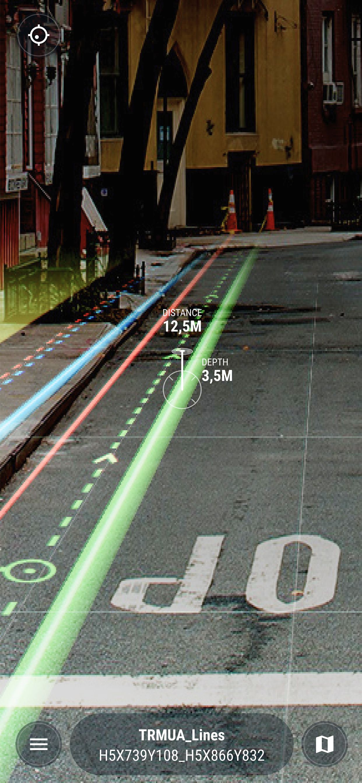
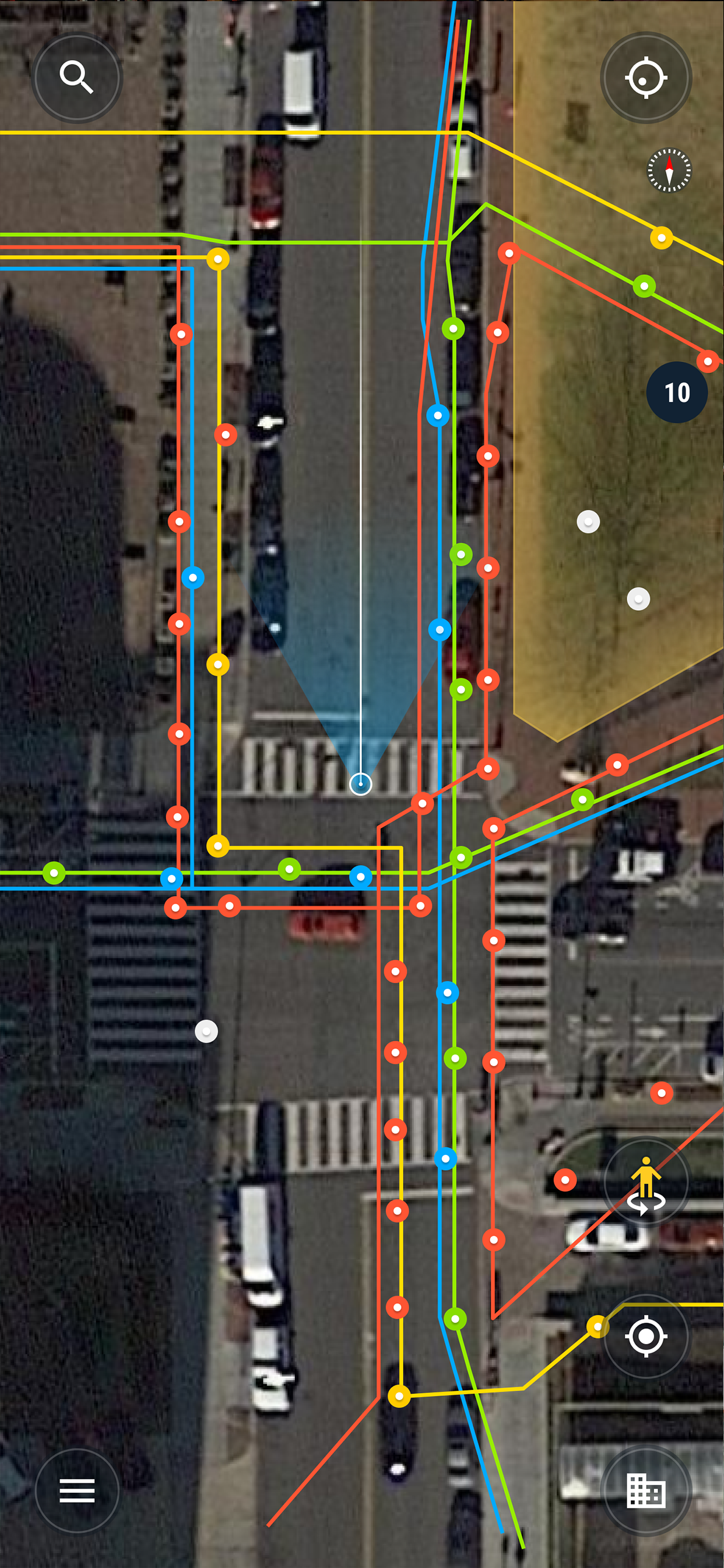
Using the vGIS system, field personnel can see an augmented view that includes holographic infrastructure objects, improving their environmental assessments and increasing their situational awareness. From delivering real-time, in-field holographic visualizations of underground pipes, valves, cables and other utility objects to visualizing ground penetrating radar scans, vGIS solutions are estimated to prevent 25% of excavation-related accidents resulting from human error, among other benefits.
The system combines object holograms with object-specific data to provide a hands-free method for field technicians to understand the infrastructure they need to service while on site, quickly and safely.
Key features:
• Exceptional Accuracy
• Consistent Visualizations: 3D overlays stay “world-locked” by remaining in sync with the physical world
• Multi-Device Support
• No Additional Equipment: vGIS Utilities does not require any additional equipment
• Workflow Integration: vGIS Utilities integrates with your existing back-office systems
• Advanced Collaboration: Integrated holograms, video, and audio that connect the office with field teams
• Format Support: Esri Feature Services, Esri Map Services, Esri Scene Services, Esri Building Services, Bentley iTwin, WFS, WMS, WMTS, GeoJSON, KML
• GNSS Integration: Leica GG04 plus, EOS Arrow Series, SXBlue, TopCon and Trimble R series/Catalyst
• Multi-View Support: First-person on-site experience and birds-eye “zoom out” site overviews
Hide..
Show more..
The system combines object holograms with object-specific data to provide a hands-free method for field technicians to understand the infrastructure they need to service while on site, quickly and safely.
Key features:
• Exceptional Accuracy
• Consistent Visualizations: 3D overlays stay “world-locked” by remaining in sync with the physical world
• Multi-Device Support
• No Additional Equipment: vGIS Utilities does not require any additional equipment
• Workflow Integration: vGIS Utilities integrates with your existing back-office systems
• Advanced Collaboration: Integrated holograms, video, and audio that connect the office with field teams
• Format Support: Esri Feature Services, Esri Map Services, Esri Scene Services, Esri Building Services, Bentley iTwin, WFS, WMS, WMTS, GeoJSON, KML
• GNSS Integration: Leica GG04 plus, EOS Arrow Series, SXBlue, TopCon and Trimble R series/Catalyst
• Multi-View Support: First-person on-site experience and birds-eye “zoom out” site overviews
Screenshots


 User Rating
0 out of 5
0 ratings in Denmark
Ratings History
Reviews
App doesn't have any reviews yet
Store Rankings
Ranking History
App Ranking History not available yet
Category Rankings
App is not ranked yet
Keywords
Users may also like
| Name | Reviews | Recent release | |
|---|---|---|---|

GAMMA AR
AR + BIM for Construction & FM
|
0
|
4 weeks ago | |

VisualLive
AR solution for AEC and BIM
|
0
|
1 year ago | |
The Argis® Lens
Augmented Reality for GIS
|
0
|
11 months ago | |

ArcGIS Indoors
An Indoor Mapping System
|
0
|
7 months ago | |
|
SYNCHRO Field
|
0
|
1 month ago | |

Augview
AR for Asset Management
|
0
|
9 months ago | |

Esri Support
|
0
|
1 week ago | |

Trimble Connect AR
AR Visualization for AEC
|
0
|
4 months ago | |

Trimble SiteVision
|
0
|
1 month ago | |

Touch GIS
Advanced field data collection
|
0
|
1 month ago |
Show More
Revenue and Downloads
Gain valuable insights into vGIS AR performance with our analytics. Sign up now
to
access downloads, revenue, and more.
App Info
- Category
- Productivity
- Publisher
- vGIS Inc.
- Languages
- Japanese, Italian, Dutch, Swedish, Spanish, German, Norwegian Bokmål, French, Portuguese, Russian, English, Korean
- Recent version
- 3.33.0 (3 weeks ago )
- Released on
- Jan 18, 2018 (6 years ago )
- Also available in
- United States, Canada, Japan, United Kingdom, Netherlands, Ukraine, Poland, Philippines, Singapore, Australia, New Zealand, South Africa, South Korea, Kuwait, Kazakhstan, Lebanon, Mexico, Malaysia, Nigeria, Vietnam, Norway, Thailand, Peru, Taiwan, Pakistan, India, Portugal, Romania, Russia, Saudi Arabia, Sweden, Turkey, Dominican Republic, Argentina, Austria, Azerbaijan, Belgium, Brazil, Belarus, Switzerland, Chile, China, Colombia, Czechia, Germany, Denmark, Italy, Algeria, Ecuador, Egypt, Spain, Finland, France, Greece, Hong Kong, Hungary, Indonesia, Ireland, Israel, United Arab Emirates
- Last updated
- 1 month ago