
Wanderfreund
Published by:
Wanderfreund Trails UG (Haftungsbeschrankt)
Description
Wanderfreund ist dein digitaler Guide für Weitwanderwege und Langstrecken-Wandertouren in Deutschland. Wanderfreund bietet dir alles, was du als "thru-hiker" brauchst, um die schönsten deutschen Trails zu erkunden. Wanderfreund umfasst folgende Features:
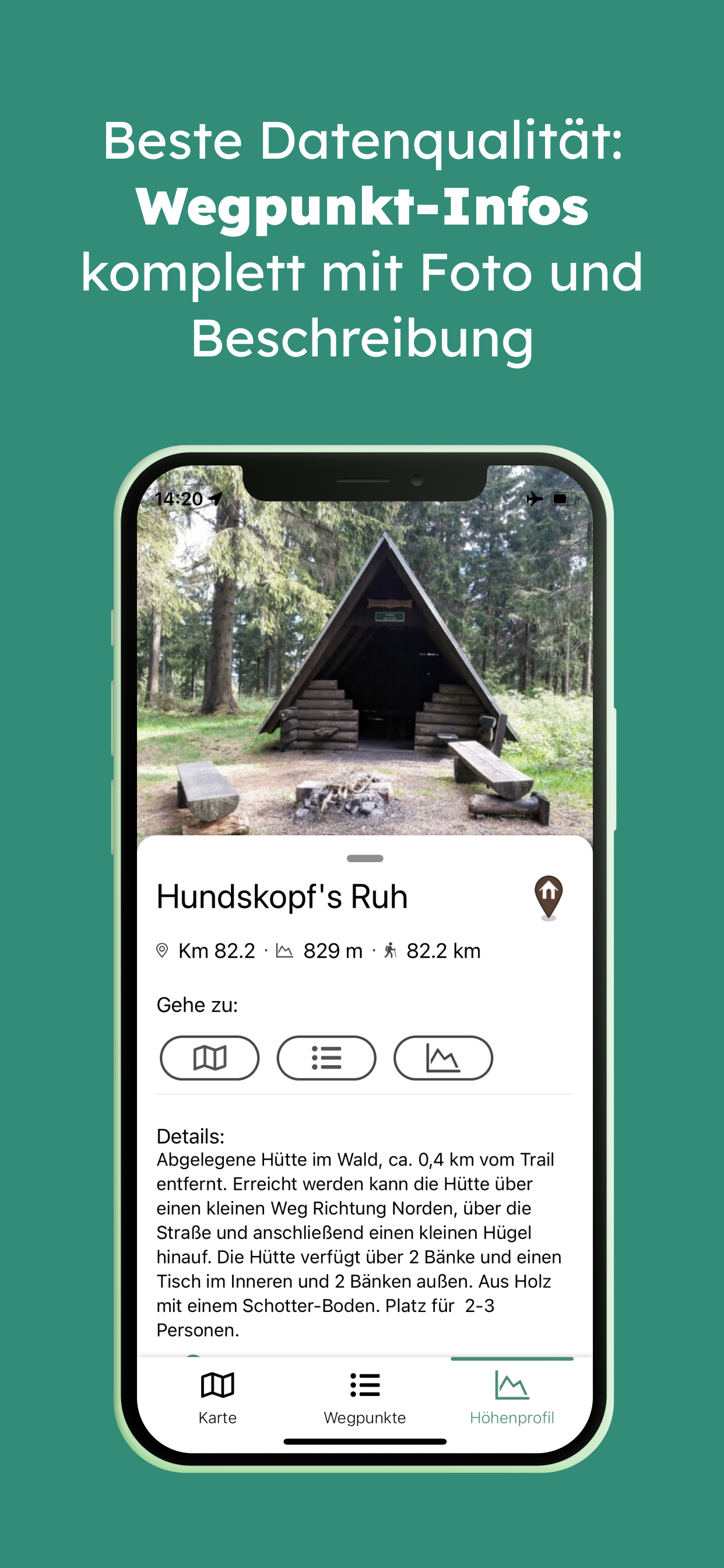
- Professionelle und aktuelle Wanderweginformationen: Exakter Routenverlauf, Höhenprofil und tausende Wegpunkte.
- Wegpunkte enthalten detaillierte Beschreibungen und Fotos für Hütten, Wasserquellen, Städte, Transportmittel und mehr.
- Echtzeit-Berechnungen zeigen die exakte Strecke zwischen dem eigenen Standort und jedem anderen Ort auf dem Trail.
- Höhenprofil mit eigenem Standort in Echtzeit entlang aller Wegpunkte.
- Detaillierte Qualitäts-Karten.
- Funktioniert alles Offline: Einfach alle Wegpunktinformationen, Fotos und Kartentypen herunterladen und auf dem Trail auch ohne Empfang navigieren.
- Zugang zur engagierten Weitwander-Community, die Live-Informationen und Updates über den Trail und die einzelnen Wegpunkte mit allen anderen über die Kommentar-Funktion teilt.
- Trails in unserem Wanderführer: Rennsteig, Westweg, Hochrhöner, Weserberglandweg, Harzer Hexenstieg, Altmühltal Panoramaweg, Kammweg Erzgebirge-Vogtland. Viele weitere befinden sich in der Pipeline.
Hide
Show More...
- Professionelle und aktuelle Wanderweginformationen: Exakter Routenverlauf, Höhenprofil und tausende Wegpunkte.
- Wegpunkte enthalten detaillierte Beschreibungen und Fotos für Hütten, Wasserquellen, Städte, Transportmittel und mehr.
- Echtzeit-Berechnungen zeigen die exakte Strecke zwischen dem eigenen Standort und jedem anderen Ort auf dem Trail.
- Höhenprofil mit eigenem Standort in Echtzeit entlang aller Wegpunkte.
- Detaillierte Qualitäts-Karten.
- Funktioniert alles Offline: Einfach alle Wegpunktinformationen, Fotos und Kartentypen herunterladen und auf dem Trail auch ohne Empfang navigieren.
- Zugang zur engagierten Weitwander-Community, die Live-Informationen und Updates über den Trail und die einzelnen Wegpunkte mit allen anderen über die Kommentar-Funktion teilt.
- Trails in unserem Wanderführer: Rennsteig, Westweg, Hochrhöner, Weserberglandweg, Harzer Hexenstieg, Altmühltal Panoramaweg, Kammweg Erzgebirge-Vogtland. Viele weitere befinden sich in der Pipeline.
Screenshots


Wanderfreund FAQ
-
Is Wanderfreund free?
Yes, Wanderfreund is completely free and it doesn't have any in-app purchases or subscriptions.
-
Is Wanderfreund legit?
Not enough reviews to make a reliable assessment. The app needs more user feedback.
Thanks for the vote -
How much does Wanderfreund cost?
Wanderfreund is free.
-
What is Wanderfreund revenue?
To get estimated revenue of Wanderfreund app and other AppStore insights you can sign up to AppTail Mobile Analytics Platform.

User Rating
App is not rated in Taiwan yet.
Ratings History
Wanderfreund Reviews
Store Rankings
Ranking History
App Ranking History not available yet
Category Rankings
App is not ranked yet
Wanderfreund Competitors
| Name | Downloads (30d) | Monthly Revenue | Reviews | Ratings | Recent release | |
|---|---|---|---|---|---|---|

THÜRINGER WALD
|
Unlock
|
Unlock
|
0
|
|
2 years ago | |

Alpe Adria Trail
|
Unlock
|
Unlock
|
0
|
|
2 weeks ago | |

urbnups
|
Unlock
|
Unlock
|
0
|
|
8 months ago | |

neanderland STEIG Hiking App
|
Unlock
|
Unlock
|
0
|
|
2 months ago | |

Wanderroutenplaner NRW mobil
|
Unlock
|
Unlock
|
0
|
|
2 years ago | |

Weserbergland – Urlaubsplaner
|
Unlock
|
Unlock
|
0
|
|
11 months ago | |

Via Transalpina
|
Unlock
|
Unlock
|
0
|
|
3 years ago | |

HexaTrek : Thru Hike France
Map & Guide Outdoor
|
Unlock
|
Unlock
|
0
|
|
1 year ago | |

Next Picnic
|
Unlock
|
Unlock
|
0
|
|
7 months ago | |

World Heritage in the Harz
|
Unlock
|
Unlock
|
0
|
|
1 year ago |
Wanderfreund Installs
Last 30 days
Wanderfreund Revenue
Last 30 daysWanderfreund Revenue and Downloads
Gain valuable insights into Wanderfreund performance with our analytics.
Sign up now to access downloads, revenue, and more.
Sign up now to access downloads, revenue, and more.
App Info
- Category
- Navigation
- Languages
- German, English
- Recent release
- 1.0 (2 years ago )
- Released on
- May 23, 2022 (2 years ago )
- Also available in
- Germany , United States , Austria , Italy , Ireland , Japan , Kuwait , Mexico , Nigeria , Netherlands , Norway , New Zealand , Peru , Poland , Romania , Russia , Saudi Arabia , Sweden , Singapore , Thailand , Taiwan , Ukraine , Algeria , Australia , Belgium , Canada , Switzerland , Chile , Colombia , Czechia , Denmark , Dominican Republic , Israel , Egypt , Spain , Finland , France , United Kingdom , Greece , Hong Kong SAR China , Hungary
- Last Updated
- 6 days ago
This page includes copyrighted content from third parties, shared solely for commentary and research in accordance with fair use under applicable copyright laws. All trademarks, including product, service, and company names or logos, remain the property of their respective owners. Their use here falls under nominative fair use as outlined by trademark laws and does not suggest any affiliation with or endorsement by the trademark holders.