
Description
Be prepared! Plan your next trip to one of the great Washington parks. Download maps and guides before you venture into the Wi-Fi free wilderness.
Discover
- 90+ national parks, state parks, monuments, forests
- 180+ neatly folded maps by the National Park Service, Bureau of Land Management, United States Forest Services, and other agencies.
- Motor Vehicle Use Maps (MVUM), Motor Vehicle Travel Maps (MVTM) and visitor maps for Texas national forests.
- 1,700+ campgrounds and campsites
- 2,800+ trails and trailheads
- 58,000+ points of interests
Plan
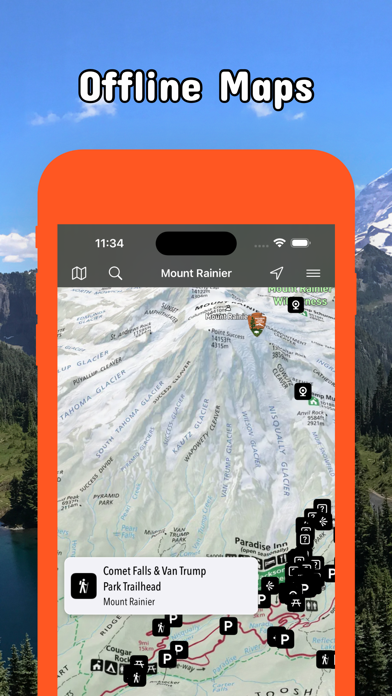
- Download maps, park brochures, and newspapers. These downloads are ready when you are offline and off the grid in the great outdoors.
- Download arbitrary map sections as offline packs.
- Photo galleries, panorama views.
- Share links to parks and maps with friends
Have fun
- GPS and GPX support: record your hikes, import GPX routes, tracks and waypoints for your hiking trails.
- Detailed national park information: alerts, news, visitor centers, campgrounds, driving directions, weather.
- Open your favorite maps app to get a route to the selected park.
- Current weather conditions, easy access to multi-day forecasts, sunrise and sunset times.
- Push notifications for park alerts, park news, weather warnings
So download maps and guides for:
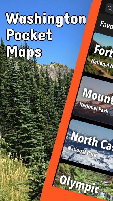
Chopaka Lake and Chopaka Mountain
Columbia River Gorge
Colville
Ebey's Landing
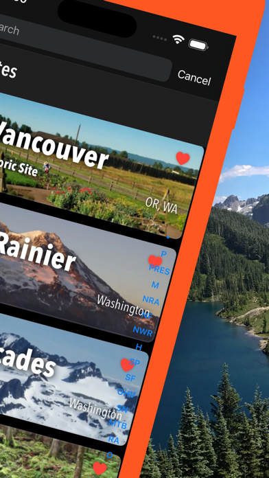
Fort Vancouver
Gifford Pinchot
Goat Rocks
Idaho Panhandle
Klondike Gold Rush
Lake Chelan
Lake Roosevelt
Lewis & Clark
Minidoka
Mount Adams
Mount Rainier
Mount St Helens
Mt. Baker-Snoqualmie
Nez Perce
North Cascades
Okanogan
Olympic
Ross Lake
San Juan Island
Wenatchee
Whitman Mission
There are additional useful maps and brochures for many Washington state parks, Sno-Parks and mountain bike areas like
Ahtanum, Albian Hill, Alpine Baldy, Blanchard, Blewett Pass, Bonaparte, Boulder Cave, Canyon Creek, Capitol, Cherry Valley, Clear Lake, Cougar, Crystal Springs, Deer Creek Nordic, Dockton, Duthie Hill, Echo Ridge, Elbe Hills and Tahoma, Elk Heights, Fishtrap, Green Mountain and Tahuya, Henry's Ridge, Kachess Ridge, Liberty, Middle Fork Snoqualmie, North Fork Chewelah Creek, North Mountain, Palmer Mountain and Split Rock, Paradise Valley, Raging River, Summit Ridge, Swan Creek, Teanaway, Twenty-Five Mile Creek, Twin Lakes, Walker Valley, Yacolt Burn
Hide..
Show more..
Discover
- 90+ national parks, state parks, monuments, forests
- 180+ neatly folded maps by the National Park Service, Bureau of Land Management, United States Forest Services, and other agencies.
- Motor Vehicle Use Maps (MVUM), Motor Vehicle Travel Maps (MVTM) and visitor maps for Texas national forests.
- 1,700+ campgrounds and campsites
- 2,800+ trails and trailheads
- 58,000+ points of interests
Plan
- Download maps, park brochures, and newspapers. These downloads are ready when you are offline and off the grid in the great outdoors.
- Download arbitrary map sections as offline packs.
- Photo galleries, panorama views.
- Share links to parks and maps with friends
Have fun
- GPS and GPX support: record your hikes, import GPX routes, tracks and waypoints for your hiking trails.
- Detailed national park information: alerts, news, visitor centers, campgrounds, driving directions, weather.
- Open your favorite maps app to get a route to the selected park.
- Current weather conditions, easy access to multi-day forecasts, sunrise and sunset times.
- Push notifications for park alerts, park news, weather warnings
So download maps and guides for:
Chopaka Lake and Chopaka Mountain
Columbia River Gorge
Colville
Ebey's Landing
Fort Vancouver
Gifford Pinchot
Goat Rocks
Idaho Panhandle
Klondike Gold Rush
Lake Chelan
Lake Roosevelt
Lewis & Clark
Minidoka
Mount Adams
Mount Rainier
Mount St Helens
Mt. Baker-Snoqualmie
Nez Perce
North Cascades
Okanogan
Olympic
Ross Lake
San Juan Island
Wenatchee
Whitman Mission
There are additional useful maps and brochures for many Washington state parks, Sno-Parks and mountain bike areas like
Ahtanum, Albian Hill, Alpine Baldy, Blanchard, Blewett Pass, Bonaparte, Boulder Cave, Canyon Creek, Capitol, Cherry Valley, Clear Lake, Cougar, Crystal Springs, Deer Creek Nordic, Dockton, Duthie Hill, Echo Ridge, Elbe Hills and Tahoma, Elk Heights, Fishtrap, Green Mountain and Tahuya, Henry's Ridge, Kachess Ridge, Liberty, Middle Fork Snoqualmie, North Fork Chewelah Creek, North Mountain, Palmer Mountain and Split Rock, Paradise Valley, Raging River, Summit Ridge, Swan Creek, Teanaway, Twenty-Five Mile Creek, Twin Lakes, Walker Valley, Yacolt Burn
In-Apps
- access all pro features
- 7,49 €
Screenshots


User Rating
App is not rated in Greece yet.
Ratings History
Washington Pocket Maps Installs
Last 30 days
Washington Pocket Maps Revenue
Last 30 daysWashington Pocket Maps Reviews
Store Rankings
Ranking History
App Ranking History not available yet
Category Rankings
App is not ranked yet
Keywords
Washington Pocket Maps Competitors
| Name | Reviews | Recent release | |
|---|---|---|---|

Pacific Northwest Forests
Official Recreation Guide
|
0
|
11 months ago | |

Outdoors NW
Discover your next adventure
|
0
|
1 year ago | |

NP Maps
National Park & Topos maps USA
|
0
|
1 year ago | |

Parks Seeker
Exploring U.S. National Parks
|
0
|
3 weeks ago | |

Off-roading NW
Motor sports trails and more
|
0
|
1 year ago | |

Snow NW
Winter trails in WA, OR & ID
|
0
|
1 year ago | |

National Park Kiosk
A Guide to the National Parks
|
0
|
2 years ago | |

Mountain Loop Tour
|
0
|
6 months ago | |

Olympic National Park GPS Tour
Hike Olympic, Explore Seattle
|
0
|
8 months ago | |

White Pass Scenic Byway
|
0
|
2 years ago |
Washington Pocket Maps Revenue and Downloads
Gain valuable insights into Washington Pocket Maps performance with our analytics.
Sign up now to access downloads, revenue, and more.
Sign up now to access downloads, revenue, and more.
App Info
- Category
- Travel
- Publisher
-
Alex Gugel

- Languages
- Catalan, Croatian, Czech, Danish, Dutch, English, Finnish, French, German, Greek (modern), Hindi, Hungarian, Indonesian, Italian, Japanese, Korean, Malay, Norwegian Bokmål, Polish, Portuguese, Romanian, Russian, Slovak, Spanish, Swedish, Thai, Chinese, Turkish
- Recent version
- 6.6 (3 weeks ago )
- Released on
- Apr 8, 2020 (4 years ago )
- Also available in
- United States, Germany, Czechia, Thailand, Hong Kong, Peru, Poland, New Zealand, Norway, Netherlands, Nigeria, Malaysia, Mexico, Lebanon, Kazakhstan, Kuwait, South Korea, Japan, Philippines, Pakistan, India, Portugal, Romania, Russia, Saudi Arabia, Sweden, Singapore, Turkey, Taiwan, Ukraine, Vietnam, South Africa, Dominican Republic, Argentina, Austria, Australia, Azerbaijan, Belgium, Brazil, Belarus, Canada, Switzerland, Chile, China, Colombia, Denmark, Italy, Algeria, Ecuador, Egypt, Spain, Finland, France, United Kingdom, Greece, Hungary, Indonesia, Ireland, Israel, United Arab Emirates
- Last updated
- 3 weeks ago