
Waterscope Weather
For people who love water.
#1 Keyword Rankings
Today
Top 10 Rankings
Today
Top 30 Rankings
Today
Top 100 Rankings
Today
Description
Waterscope is a weather app for people who love being around water. Whether you're surfing, fishing, boating, or just taking the dog for a walk on the beach, Waterscope will keep you informed about your local conditions.
The data presented comes from the National Oceanic and Atmospheric Administration (NOAA) and National Weather Service (NWS). This app would not be possible without the scientific contributions from the people at these valuable public institutions.
The app uses a series of screens to present this information:
HOME
When you launch Waterscope, you'll be presented with a screen that shows a graph of high and low tides for the nearest measuring station. Below that are wave heights and water temperatures for the closest NOAA buoy. These are followed by wind speed and air temperature measurements for a nearby NWS weather station. Above the graphs, you'll see the current phase of the Moon and its position on the horizon. Below you'll see the sun's position relative to your location on Earth.
The clock at the bottom shows the current time, or the time for past data samples and future forecasts. Tap on the clock to scroll back to the current time.
Tap on any large blue ring to show more information. Smaller blue rings make adjustments to what you're currently viewing. Tapping on the icon in the upper-left corner will show an overlay that explains the symbols and markers.
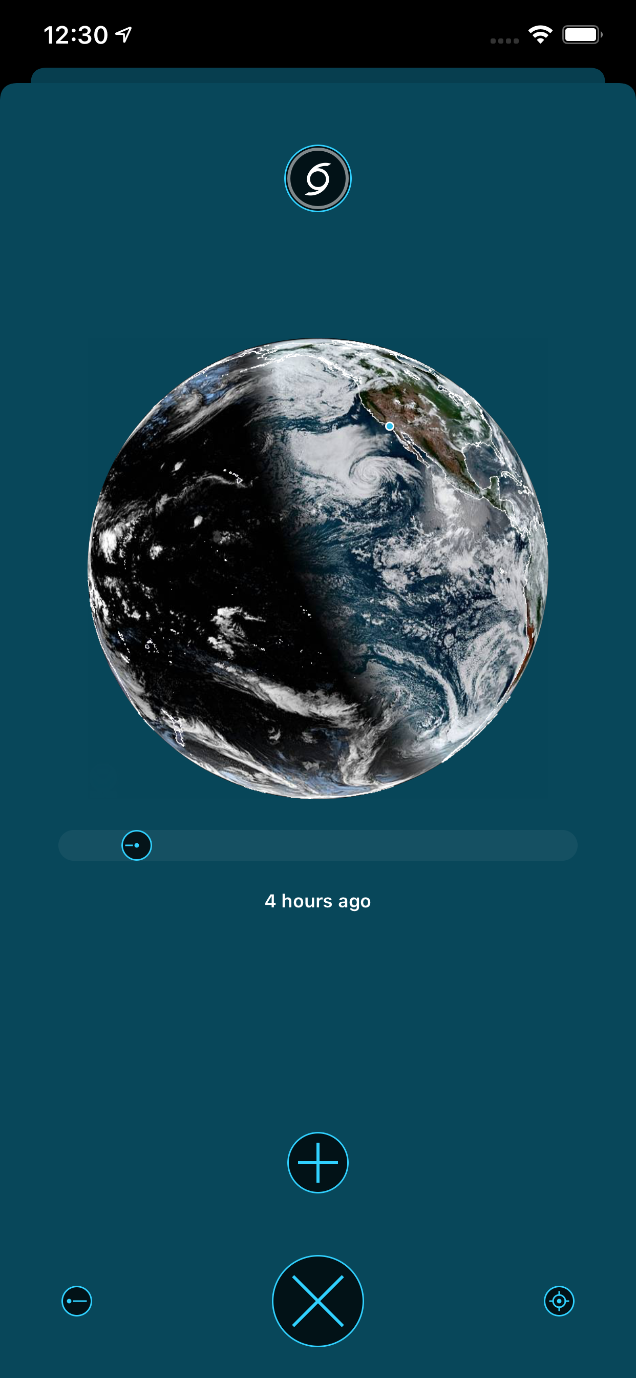
EARTH
The Earth view shows the last 24 hours of satellite imagery near your current location (the small blue dot is you!) Tap the + button to see a larger version of the latest image. The hurricane symbol at the top of the view will show the latest forecasts from the National Hurricane Center.
MOON
The Moon view shows the phase and location of the Moon for the next year. The white dot shows the height above the horizon, and when you align the blue arrow with the centerline and look up you'll see Earth's biggest satellite :-)
SEA
This view of the sea shows markers for observations collected by the National Data Buoy Center. The arrow points in the directions waves are heading: tap it to show water temperature, wave height, and an average period between waves. To make any buoy's data show up on the home screen, tap the heart icon.
LAND
Like the view of the sea, but with onshore observations collected by the National Weather Service. The arrow shows wind direction and tapping the marker shows the air temperature, wind speed with gusts, and barometric pressure. Tap the heart to add it to home.
TIDE
This view shows nearby tide stations: tap on any marker to get the current prediction at that location. Like the other map views, the tide station can be added to the main screen using the heart icon.
FORECAST
If you move forward in time, you'll see a forecast for air temperature and conditions. Tap on the conditions to get an expanded view that includes wind speed and direction.
Hide..
Show more..
The data presented comes from the National Oceanic and Atmospheric Administration (NOAA) and National Weather Service (NWS). This app would not be possible without the scientific contributions from the people at these valuable public institutions.
The app uses a series of screens to present this information:
HOME
When you launch Waterscope, you'll be presented with a screen that shows a graph of high and low tides for the nearest measuring station. Below that are wave heights and water temperatures for the closest NOAA buoy. These are followed by wind speed and air temperature measurements for a nearby NWS weather station. Above the graphs, you'll see the current phase of the Moon and its position on the horizon. Below you'll see the sun's position relative to your location on Earth.
The clock at the bottom shows the current time, or the time for past data samples and future forecasts. Tap on the clock to scroll back to the current time.
Tap on any large blue ring to show more information. Smaller blue rings make adjustments to what you're currently viewing. Tapping on the icon in the upper-left corner will show an overlay that explains the symbols and markers.
EARTH
The Earth view shows the last 24 hours of satellite imagery near your current location (the small blue dot is you!) Tap the + button to see a larger version of the latest image. The hurricane symbol at the top of the view will show the latest forecasts from the National Hurricane Center.
MOON
The Moon view shows the phase and location of the Moon for the next year. The white dot shows the height above the horizon, and when you align the blue arrow with the centerline and look up you'll see Earth's biggest satellite :-)
SEA
This view of the sea shows markers for observations collected by the National Data Buoy Center. The arrow points in the directions waves are heading: tap it to show water temperature, wave height, and an average period between waves. To make any buoy's data show up on the home screen, tap the heart icon.
LAND
Like the view of the sea, but with onshore observations collected by the National Weather Service. The arrow shows wind direction and tapping the marker shows the air temperature, wind speed with gusts, and barometric pressure. Tap the heart to add it to home.
TIDE
This view shows nearby tide stations: tap on any marker to get the current prediction at that location. Like the other map views, the tide station can be added to the main screen using the heart icon.
FORECAST
If you move forward in time, you'll see a forecast for air temperature and conditions. Tap on the conditions to get an expanded view that includes wind speed and direction.
Screenshots


 User Rating
0 out of 5
0 ratings in Dominican Republic
Ratings History
Reviews
App doesn't have any reviews yet
Store Rankings
Ranking History
App Ranking History not available yet
Category Rankings
App is not ranked yet
Keywords
Users may also like
| Name | Reviews | Recent release | |
|---|---|---|---|

Earth++
Un visor de clima 3D
|
0
|
1 week ago | |

Dark Sky Widget: Weather Up
US National Weather Service
|
0
|
3 months ago | |

Mercury Weather
Local Forecasts & Live Widgets
|
0
|
3 days ago | |

Weather Strip
Forecasts at a glance
|
0
|
3 weeks ago | |

Breathable Air Quality Widget
Is it safe to go outside?
|
0
|
2 years ago | |

Snowflake Weather
Incredibly detailed weather
|
0
|
2 years ago | |

WeatherGraph: Visual Forecasts
NWS Weather in Chart Format
|
0
|
5 months ago | |

Ocean Water Temperature
NOAA Temp and Tide Data
|
0
|
1 year ago | |

Mareas cercanas-Sin publicidad
Find Nearby Tides and Currents
|
0
|
1 year ago | |

GOES Viewer
|
0
|
2 years ago |
Show More
Revenue and Downloads
Gain valuable insights into Waterscope Weather performance with our analytics. Sign up now
to
access downloads, revenue, and more.
App Info
- Category
- Weather
- Publisher
- The Iconfactory
- Languages
- English
- Recent version
- 1.0.6 (8 months ago )
- Released on
- Dec 22, 2020 (3 years ago )
- Also available in
- United States, Canada, United Kingdom, Spain, Germany, Russia, Australia, Turkey, Sweden, Malaysia, Peru, New Zealand, Norway, Netherlands, Nigeria, Portugal, Mexico, Lebanon, Kazakhstan, Kuwait, South Korea, Philippines, Pakistan, Poland, India, Romania, Saudi Arabia, Singapore, Thailand, Taiwan, Ukraine, Vietnam, South Africa, Algeria, Argentina, Austria, Azerbaijan, Belgium, Brazil, Belarus, Switzerland, Chile, China, Colombia, Czechia, Denmark, Dominican Republic, Japan, Ecuador, Egypt, Finland, France, Greece, Hong Kong, Hungary, Indonesia, Ireland, Israel, United Arab Emirates, Italy
- Last updated
- 1 month ago