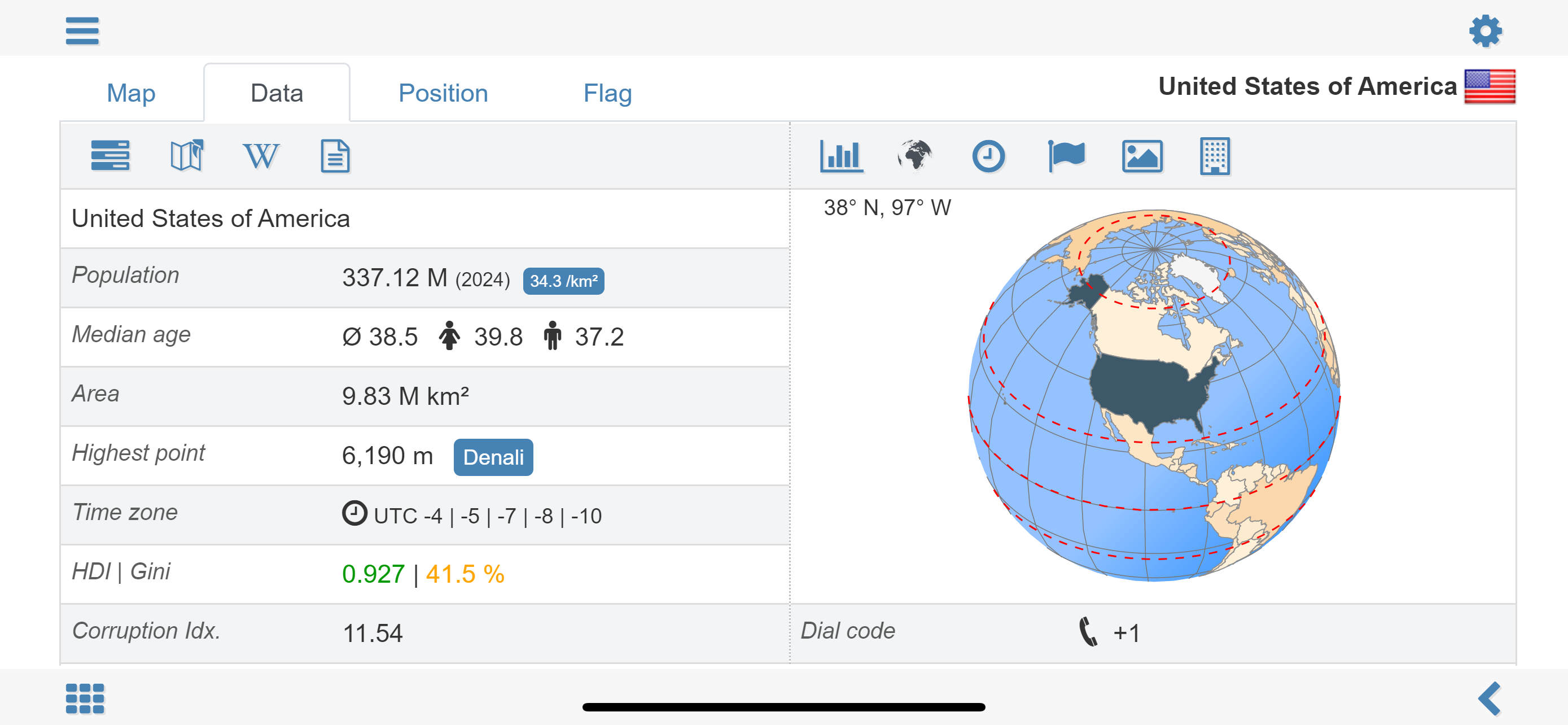
World atlas, world map and educational app for geography. Contains over 260 countries and territories of the world with comprehensive economic and geopolitical data. Political maps with regional units (provinces), capitals and major cities included.
• Maps, flags and comprehensive data for over 260 countries and territories of the world
• Interactive political world, continent and country maps
• Shaded relief layer for world and continent maps
• Historical political world and continent maps of 1900, 1930 and 1960
• Geography quiz: capitals, flags, federal states, ...
• Country comparison, favorites and distance calculator
• Print maps and country data
• World-explorer: the smallest, largest, wealthiest, and most populated countries of the world
• World Explorer: largest cities, longest rivers and highest mountains
• Choropleth maps: temperature, area, HDI, population, ...
• Search for countries, major cities, rivers, deserts, lakes, mountains or coordinates
Explore the world by political continent and country offline maps. Whether Europe, Africa, Asia, Oceania, South and North America: maps of all continents and countries are included. Learn where each country in the world is located. View its position highlighted on a digital globe. Create your favorite color theme or choose from different color schemes for map display.
Do you know the flag of Mauritius? Yes? Perfect. Do you also know in which country Mount Everest is located?
Increase your general geography knowledge in a playful manner. MxGeo Quiz: test your geographic literacy on various topics:
• Do you know the longest rivers on Earth?
• Federal states / provinces for selected countries
• Test your knowledge about the capitals in the world
• Recognize the proper country flag based on the outline map
• Do you know the top-level domains of the world's countries
• Guess the highlighted country on the virtual globe
• Guess the right country by the flag
• Do you know the ISO countries codes of the world?
• Do you know the mountains of the world?
Each quiz offers seven regional variants: World, Europe, Africa, Asia, Oceania, South or North America.
Geo learning app and educational game which is fun for everyone whether children, adults, seniors or teachers. Get ready for your next stay abroad while enjoying this great world almanac including time zones and statistical data, such as population growth, unemployment rate, average age, gross domestic product (GDP) by sector and other key figures. Or prepare for your next geography lesson with this genius digital world map. If not traveling our world atlas lets you explore the world just only virtually.
Enjoy this comprehensive atlas of the World including Europe, Asia, North America, Africa, Oceania and South America with all countries and regional units, capitals and flags.
Hide..Show more..
Screenshots
User Rating
4.68 out of 5
69 ratings
in United States
5 star
57
4 star
6
3 star
3
2 star
2
1 star
1
Ratings History
Reviews
Ok changed my mind
Alaska and Hawaii are two other states of the USA I only see 48 states with no Alaska and Hawaii. Also, Pakistan and china have the same color and they still have the same even when I change color! Fix these bugs now and add Alaska and Hawaii
NEVER MIND!!!!
ALASKA AND HAWAII IS OUT OF THE MAP!!! THAT'S SO COOL
Route Navigation.
I like the distance calculator except for the fact that it’s only related to aviation the shipping routes are not available however it’s still good though.i have used this app for over 10 years .
I am so impressed
There is a plethora of information that can be accessed off-line. Definitely worth the money.
Excellent work, developers.
Another great update.
1. The Cidima zone split from the Southern Nations, mationalities and Peoples region to form the Cidima region.
2. In Alaska the Valdez Cordova Census Area was split into theChugach and Copper River Census Areas.
Love it so much
The Papua New Guinea 🇵🇬 appears a geography map of the states but it needs a new update just like roblox car crushers 2 updates tommorow
Error independe day, all countries.
Error Indepense error day, all countries.
one day less. Still the problem, desaponit...it is so complicate fixe that?
Incredible
This app is the ONLY updated map I’ve found. Eswatini, North Macedonia, Gitega, Nur-Sultan, they’re all there and up to date. Unbelievable amount of information in the palm of your hand.
Somewhat useful map
Not sure who this map was designed for... Don't need to know the provinces in various nations; sure would like to know the major rivers, mountain ranges, travel routes. I am reading a very interesting history book of the center of civilization - Persia, Greece, the Stans, China, etc. need to reffresh my geography as I follow along.
I'm impressed
I really like how the app allows regional subdivisions (states, provinces, cantons, counties, etc) to be displayed. This gives the opportunity to learn geography on a finer level. It's one thing to be able to distinguish Italy from Switzerland, but if you want to learn to distinguish Liguria from Tuscany, then this feature of the app is what you need. It was be fantastic if the quizzes worked at this level as well, but they currently do not. Still, this is the first geography app of this kind that I have seen with this functionality, and I am impressed.
There are other nice features, but this one really stands out.