Tut was es verspricht
Exzellent um sieine Routen zu planen & durchzuführen, bisher keinerlei Abstürze.


Yes, You Need A Map is free to download, however it contains in-app purchases or subscription offerings.
✅ The You Need A Map app appears to be high-quality and legitimate. Users are very satisfied.
You Need A Map has several in-app purchases/subscriptions, the average in-app price is €5.99.
To get estimated revenue of You Need A Map app and other AppStore insights you can sign up to AppTail Mobile Analytics Platform.

5 out of 5
2 ratings in Germany
Exzellent um sieine Routen zu planen & durchzuführen, bisher keinerlei Abstürze.
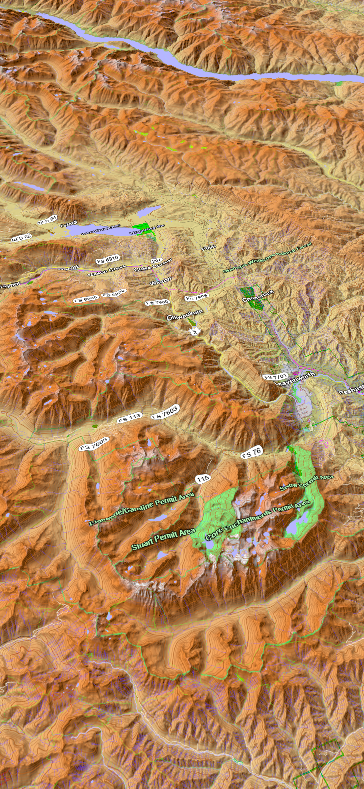
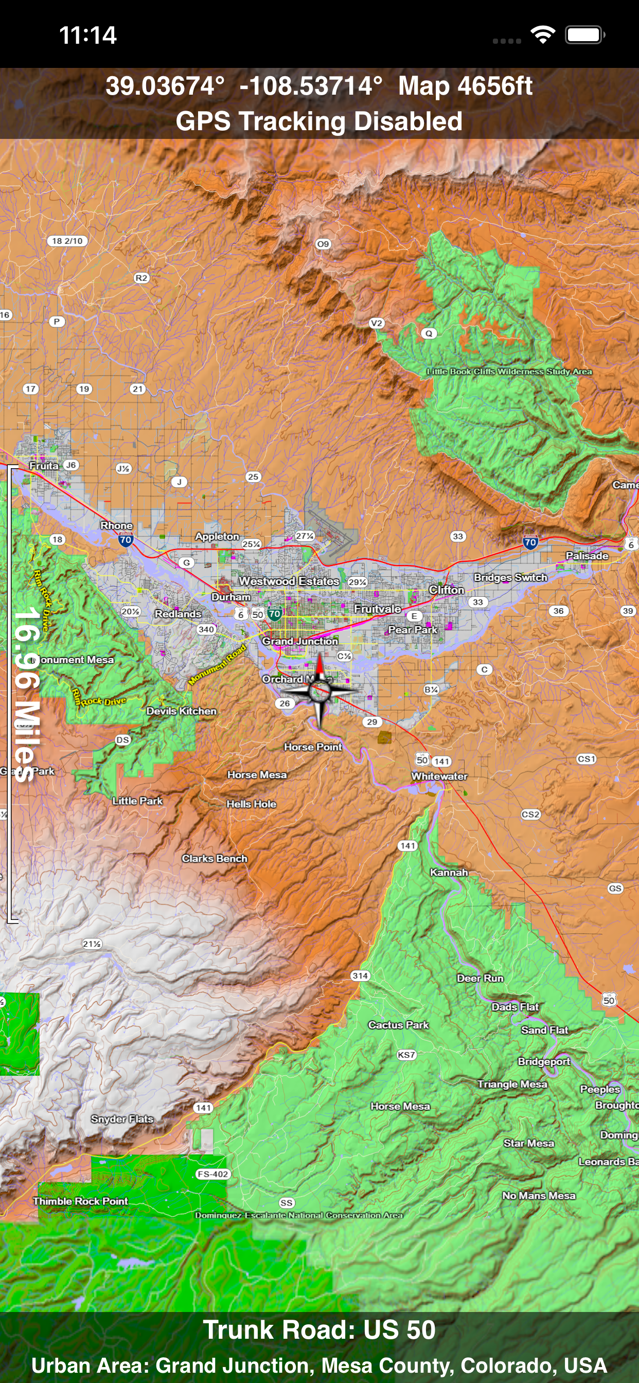
Mich wundert es sehr, dass diese tolle App so wenige Bewertungen hervorruft. Ich finde die USA-Karten ganz ausgezeichnet. Dazu gibt es unzählig viele Darstellungsoptionen, damit man festlegen kann, was und in welcher Form alles angezeigt werden soll. Super finde ich, dass man die kompletten Karten runterlädt und somit kein Internet erforderlich ist. Dazu erstaunlicherweise umsonst. Deshalb habe ich für einen kleinen Betrag die 3-D-Option dazu erworben, da die Arbeit mit einem Entgelt auch honoriert werden sollte. Für mich als USA- und Landkarten-Fan eine meiner Lieblings-Apps!
Nach Start der App. Ist lediglich der Startbildschirm zu sehen. Das ganze Betriebssystem hängte sich auf.... Weis nicht, was die App. eigentlich kann; direkt wieder gelöscht!!
I love this app and highly recommend this app. Each family member Carrie’s this on their phones for those just in case times you can’t get a signal for typical online only maps. In addition, it has lots of features for exploring areas and seeing the terrain near you. It helps me plan photography shots too! You can turn on 3D view, put up an imaginary sun, and see where shadows vs sunlight will be. Just an excellent map app.
I’ve used this flying across the country as a pilot and in the mountains hiking. No cell signal needed and the ability to leave a track so you can follow it back out.
Hey developers, When using dark mode, all alphanumeric values in ‘tracks’ will not display. The portion of tracks that I can edit will only display emojis and nothing that I have written or what is programmed to be there prior to edit. The bottom segment of tracks that I can’t edit remains visible in either mode. Just thought I’d let ya know😎
The latest update is great! You can add GPX files directly from safari downloads via the share sheet. I couldn’t be more impressed with the app. I really appreciate the customer service. Prompt responses to emails and delivering the goods World class work. Thank you
Great app. But where is Isle Royale, Michigan? The roads are there but the island is missing.
I know if I have this app on my phone and my phone in my pocket I can just start driving down a new trail some where in the bush and use this to get back later.
UPDATED 10-AUG-2018: I LOVE THIS APP- I’ve been utilizing this app as a back up (honestly, primary) to the onboard navigation equipment on a Navy MH-60S specifically for SAR Ops and identifying names and locations of local landmarks, roads, and popular trails such as the Pacific Crest Trail which is well marked within the app. UPDATE: I've also used all over the Pacific, midway, Japan, Indo, Vietnam, Singapore, Sri Lanka, PI, Indo-Asia area with zero issues. I've found that if I know where I'm going ahead of time, I'll get on Wi-Fi or data and conduct a map study, zoom in, and then cache the maps with the necessary zoom in detail as required for my flight missions. The only downside to this app is that it requires around 2GB of memory on your device to store the 3D maps (UPDATE: I got a new phone so memory is no longer an issue). But for what I do, even if I was limited on memory, I’m more than willing to give up that space on my phone/ipad for this app and the cached map data. Although I give it 5 stars, there is always room for improvement. For instance, I've got a lot of stored waypoints. I'd like to be able to prioritize my favorite waypoints towards the top of my list instead of having to scroll all the way to the bottom just to access my most frequently used ones. (If there is a way to already do that, I haven't figured it out). Also, I'd like to see the satellite imagery updated. For the price of the app and In-app Purchase, this is the best tool for the SAR community that I’ve used so far. I’ve paired my phone with a Bad Elph GPS Rx’r for better SAT reception when the phones onboard Rx’r just won’t cut it. The app eats up battery quick so when using it for extended searches/Nav, make sure you’ve got an external battery.
|
Chart
|
Category
|
Rank
|
|---|---|---|
|
Top Free
|

|
310
|
