Air Navigation - VFR & IFR

Maps, Charts, Weather, Terrain

Veröffentlicht von: Flygo-Aviation

Beschreibung

Air Navigation - VFR & IFR is the ultimate flight planning and navigation app for pilots. Plan VFR or IFR flights with worldwide charts, real-time weather (METAR/TAF), radar, NOTAMs, terrain awareness, airport information, and more – all in one easy-to-use app.
Download and try PRO free for 1 month! *
Features:
• Route planning
Create and save routes with 50,000+ airports, navaids, and waypoints.
• Maps and charts, connected to GPS
Navigate with updated sectional and en-route charts in the US and EU **. Customize maps with airports, airspaces, navaids, and weather layers.
• Weather Radar
Real-time radar with animation and 30-minute forecasts.
• Weather
Access worldwide METAR and TAF reports.
• Offline use
Download maps, charts, and terrain for offline flying.
• Terrain avoidance system ***
Stay aware of dangerous terrain with clear visual alerts.
• EHSI / RMI instruments
Fly procedures with digital navigation instruments.
• Nearby airports
Quickly find alternate airports, their distance, and relative direction.
• Real-time flight information
Heading, track, distance, ETA, ETE, speed, and waypoints.
• iCloud synchronization
Sync your data between multiple devices.
• Airport information
Runways, frequencies, navaids, NOTAMs, and weather data.
• User points
Add custom waypoints by tapping the map or entering coordinates.
• Quick tap mode
Tap any location to view airspace, frequencies, SIGMETs, AIRMETs, and runway data.
• SIGMETs & AIRMETs
Global weather advisories displayed on the map.
• Advanced search
Find airports by name, city, ICAO, or IATA.
• Navigation modes
Switch between magnetic and true north.
• Units
Choose between imperial (US) and metric units.
• Flight history
Review your past routes and flights.
* Subscriptions: BASIC and PRO. Unlimited charts, terrain, and the 1-month trial are included with PRO. BASIC offers a 2-week trial.
** EU sectional charts are available in Belgium, Germany, Finland, the Netherlands, Denmark, Poland, Sweden, Bulgaria, Croatia, Greece, Hungary, Italy, Slovenia, the Czech Republic, Malta, Austria, Romania, Switzerland, and Slovakia. Additional charts are available in South Africa and Namibia. Charts provided by Open Flight Maps.
*** Terrain data available from 60°N to 57°S.
Disclaimer: This is not a certified flight instrument. Pilots must not rely solely on the app for navigation. Always use approved avionics for flight safety.
Manual: https://www.flygo-aviation.com/wp-content/uploads/2021/10/FlyGo-Air-Navigation-Quickstart-Guide.pdf
Terms of use: https://www.flygo-aviation.com/air-navigation-terms-of-use/
Privacy policy: https://www.flygo-aviation.com/air-navigation-privacy-policy/
Ausblenden Mehr anzeigen...

In-App-Käufe

Air Navigation Pro 6 Months
USD 19.99
Air Navigation Pro 1 Month
USD 3.99
Air Navigation Basic 6 Months
USD 14.99
Air Navigation Basic 1 Month
USD 2.99

Screenshots

Air Navigation Häufige Fragen

  • Ist Air Navigation kostenlos?

    Ja, Air Navigation ist kostenlos herunterzuladen, enthält jedoch In-App-Käufe oder Abonnements.

  • Ist Air Navigation seriös?

    Nicht genügend Bewertungen, um eine zuverlässige Einschätzung vorzunehmen. Die App benötigt mehr Nutzerfeedback.

    Danke für die Stimme

  • Wie viel kostet Air Navigation?

    Air Navigation bietet mehrere In-App-Käufe/Abonnements, der durchschnittliche In-App-Preis beträgt USD 10.49.

  • Wie hoch ist der Umsatz von Air Navigation?

    Um geschätzte Einnahmen der Air Navigation-App und weitere AppStore-Einblicke zu erhalten, können Sie sich bei der AppTail Mobile Analytics Platform anmelden.

Benutzerbewertung
Die App ist in Kaimaninseln noch nicht bewertet.
Bewertungsverlauf

Air Navigation Bewertungen

Personal flying assistant, except it's much cheaper

diondria-parcell*1986 on

Vereinigte Staaten

I love the clear communication. It's like having an assistant in your pocket on the go.

Safe choice

Rason_Simno on

Vereinigte Staaten

I don't like looking at the screen while flying, so I rarely take my phone out. But I need to feel that security, so I still use it.

No bugs

sophielopezfibf on

Vereinigte Staaten

I use the app every time I pilot an aircraft. Never seen a bug, ever.

It's for pilots

Damante Trevenfrdhcwly on

Vereinigte Staaten

When downloading, I didn't think the app would have such advanced technology, but it really has all it takes to fly an aircraft!

From Basic to PRO

stylerockermdpz on

Vereinigte Staaten

First, I subscribed for the basic version but happily switched to PRO after that. There are so many new options.

Offline charts and maps

Oliver_Onyxbkwi on

Vereinigte Staaten

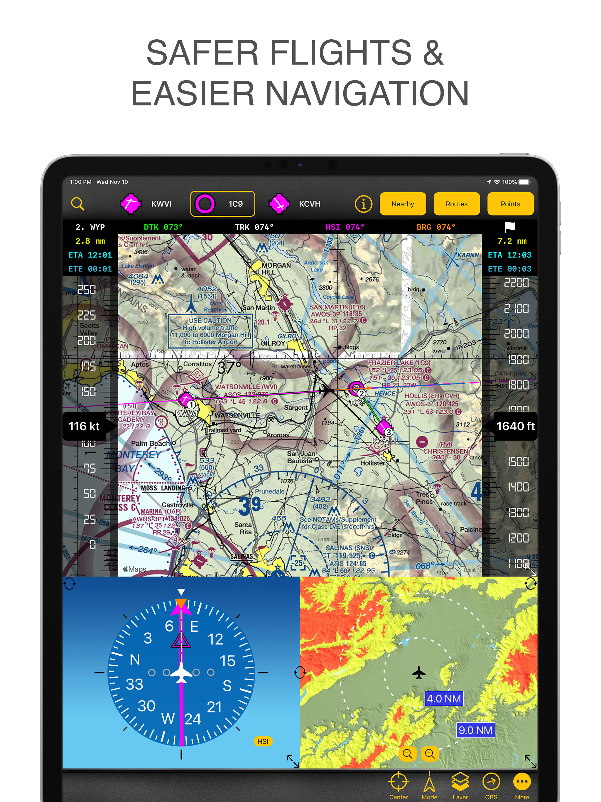
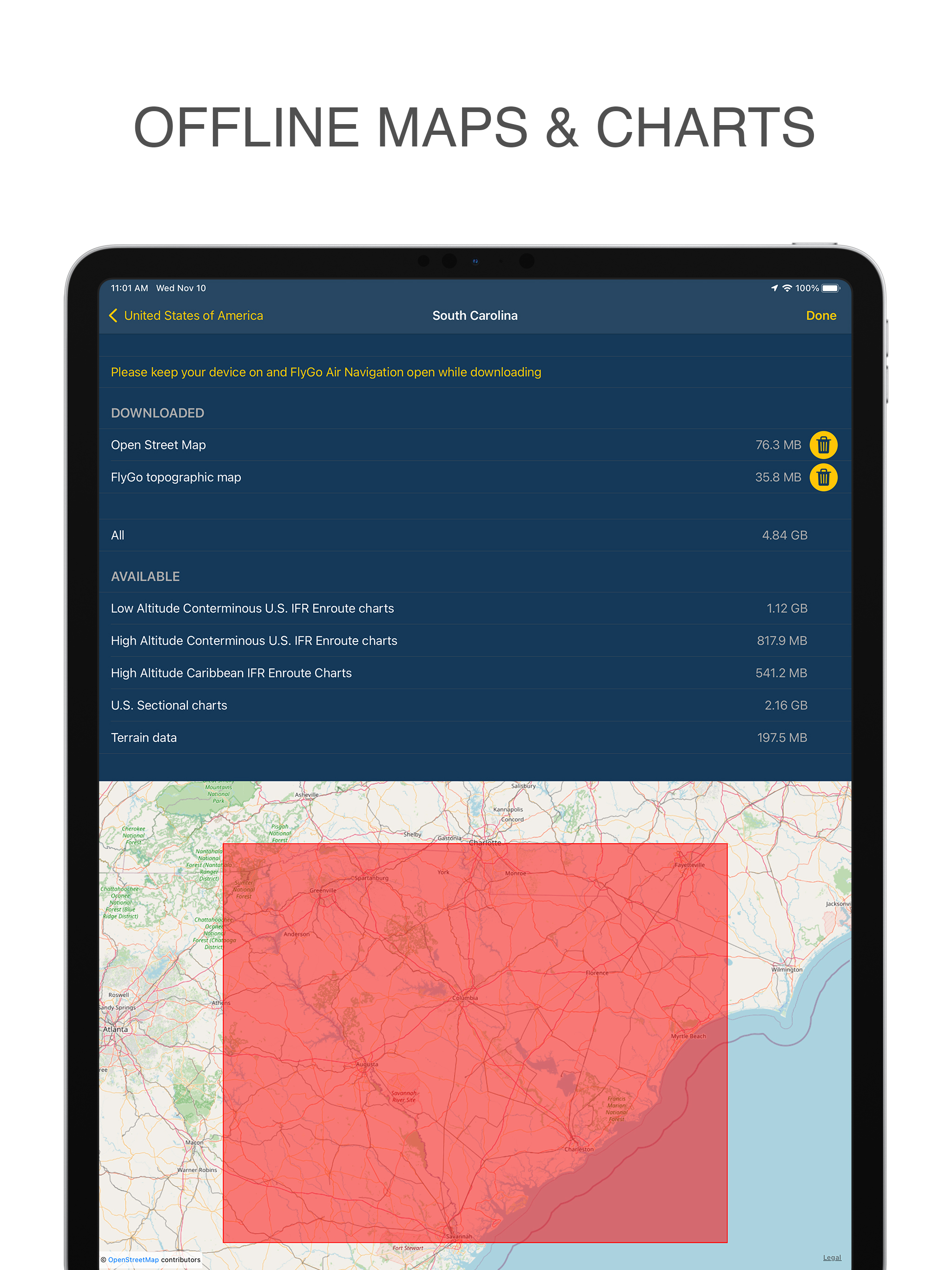
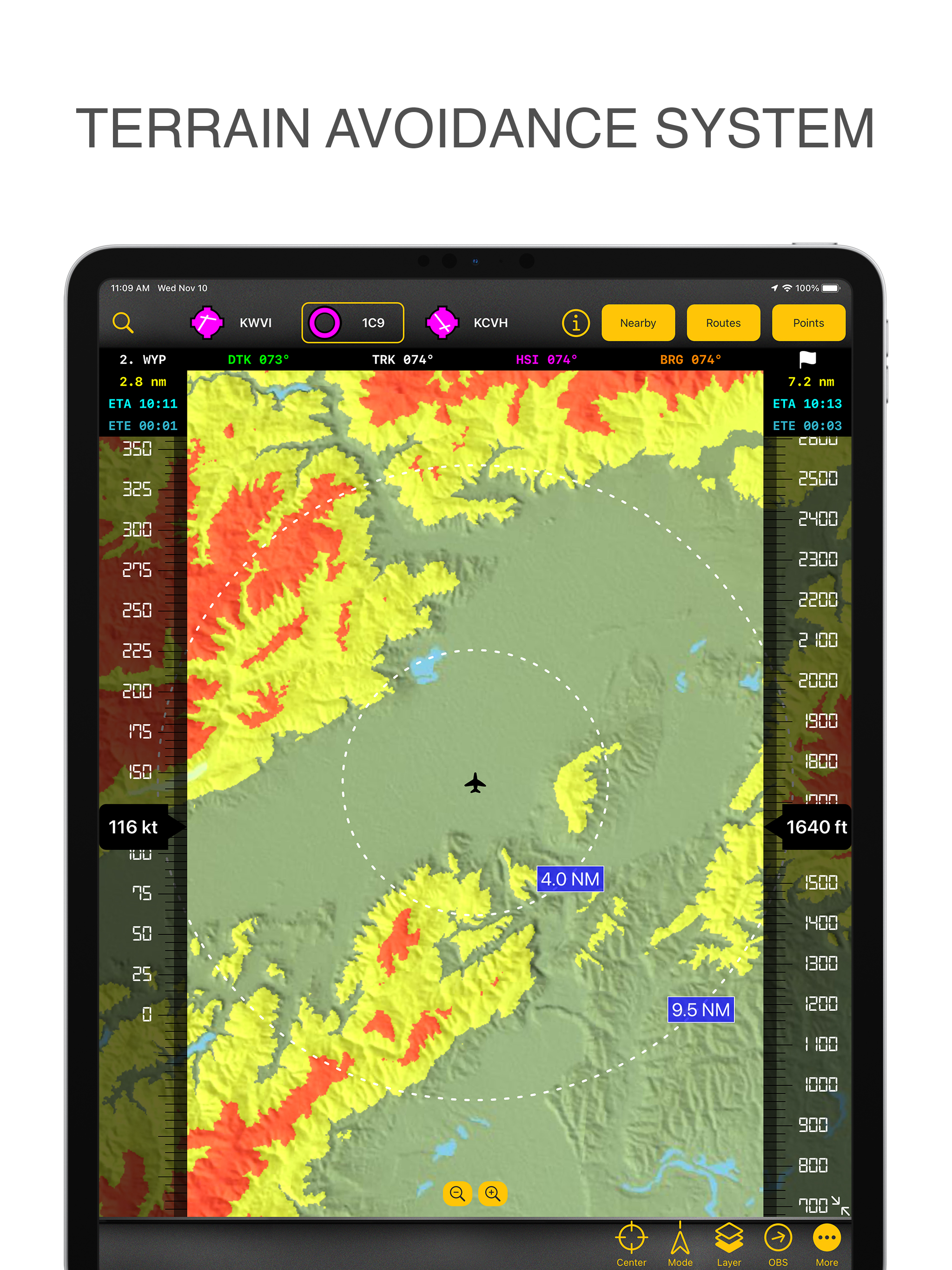
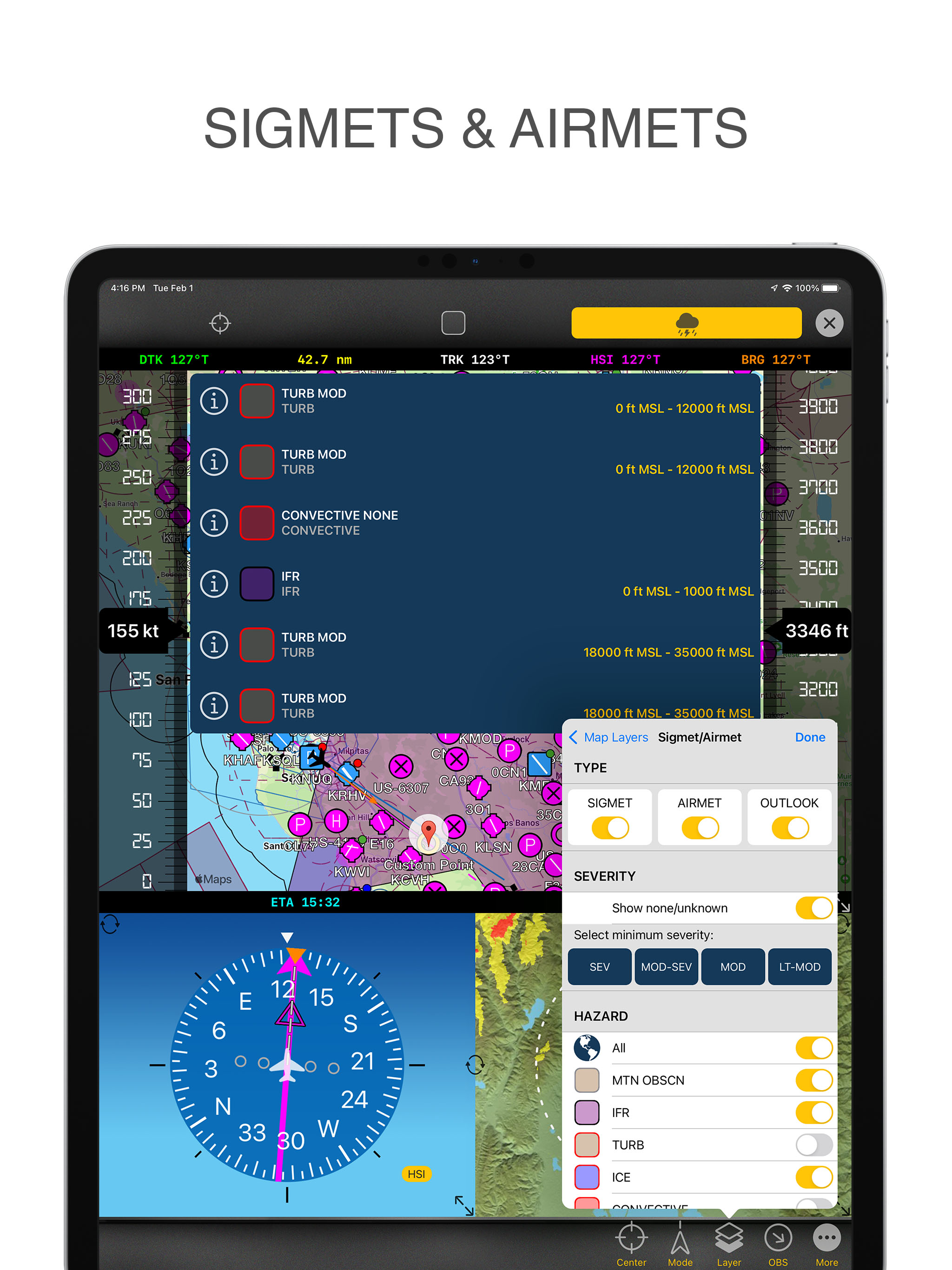
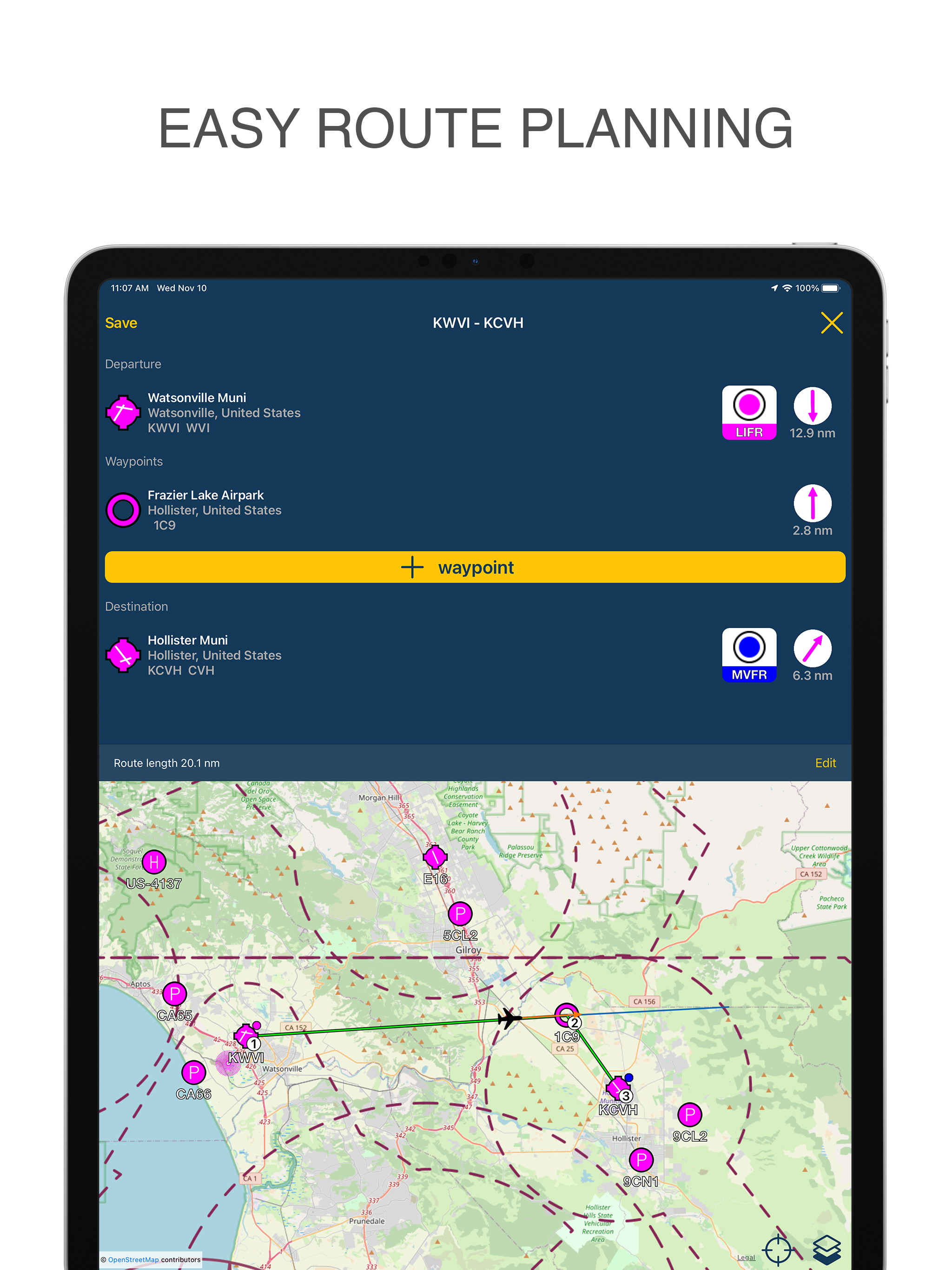
The offline use of maps and charts is awesome. The design is user-friendly, so I can quickly get all the information.

Lacking in documentation

FWBaker on

Vereinigte Staaten

Assume your customer may know nothing and make it easy for them to get started. When you assume everyone has a basic knowledge, you write off everyone who is just getting started. I see your software and I get excited. I think this could work for me. To save me and others time and dramatically increase your sales you need to work with new student pilots and pilots like me that last flew 40 years ago and just getting back in. Make a video for us that gets us started and we’ll take off. Neglect this and we will pay more for someone else who explains their software in ways we can understand! If you want be successful, don’t neglect making a how to manual for every option you provide! Good luck! Make a ton of money providing software that has an easy learning curve! Neglect this and you limit your customer base to those who already know basically what you are promoting. When I find something good that I like and I can explain it to others. That makes me and others, your best salesmen. Fritz

Store-Rankings

Ranking-Verlauf
App-Ranking-Verlauf noch nicht verfügbar
Kategorien-Rankings
Diagramm
Kategorie
Rang
Top Umsatz
40
Top Umsatz
50
Top Umsatz
63
Top Umsatz
85
Top Umsatz
85

Schlüsselwörter

Air Navigation Konkurrenten

Air Navigation Installationen

Letzte 30 Tage

Air Navigation Umsatz

Letzte 30 Tage

Air Navigation Einnahmen und Downloads

Gewinnen Sie wertvolle Einblicke in die Leistung von Air Navigation mit unserer Analytik.
Melden Sie sich jetzt an, um Zugriff auf Downloads, Einnahmen und mehr zu erhalten.
This page includes copyrighted content from third parties, shared solely for commentary and research in accordance with fair use under applicable copyright laws. All trademarks, including product, service, and company names or logos, remain the property of their respective owners. Their use here falls under nominative fair use as outlined by trademark laws and does not suggest any affiliation with or endorsement by the trademark holders.