Airports

The airport directory

Veröffentlicht von: Applicate

Beschreibung

The airport directory for your flight bag, with NOTAM, SNOWTAM, METAR and TAF reports, Favorites, Tools, and the ability to save your own notes for those airports you visit frequently.

FEATURES:
- Optimized for both the iPad and the iPhone. Buy once and use on all your iOS devices!
- Airport database containing over 27000 airports world wide.
- Quick search system lets you find airports by city, name, ICAO, IATA or Local identifier.
- Add your own notes for those airports you visit frequently. Attach photos, PDF documents and many other file types to your notes and view them within the app.
- Document Packs facilitate dissemination of airport documents to crew members.
- Cloud Sync keeps your data synchronized between all your devices.
- Runway data (dimensions and surface type) for most major airports.
- Information about types of approaches available for most major airports.
- Favorites section where you can organize your favorite airports in groups.
- Airport data includes time zone, sunrise/sunset times and ATIS frequencies for most major airports.
- On the iPhone, directly call the ATIS telephone line for airports that provide this service.
- Online satellite images for most airports (requires internet connection).
- METAR and TAF reports (requires internet connection, service not available in Russia and Belarus). Downloaded weather is saved and kept for 48 hours for offline viewing.
- View NOTAMs for most major airports (requires internet connection, service not available in Russia and Belarus). Downloaded SNOWTAMs are detected and can be decoded with one tap. Coordinates in NOTAMs are automatically decoded and can be displayed on a map for increased situational awareness.
- Email and print METAR, TAF and NOTAMs.
- List of over 180 VOLMET stations world wide, with frequencies and list of airports broadcasted by each station.
- Easily share your notes and favorites.
- Tools to calculate wind components, temperature correction, fuel uplift, approach check altitudes and great circle distances. There is also a SNOWTAM decoder and a flight duty period calculator to keep track of your estimated FDP during your duty day.

PLEASE NOTE:
This application is NOT FOR OPERATIONAL USE. Information in the airport database may be outdated and inaccurate. Please report all database errors so they can be corrected as soon as possible.
Please note that weather and NOTAM data are provided by third party sources whose accuracy and availability cannot be guaranteed. Do not rely on this data for flight planning purposes. Always crosscheck with official sources.
Ausblenden Mehr anzeigen...

Screenshots

Airports Häufige Fragen

  • Ist Airports kostenlos?

    Ja, Airports ist komplett kostenlos und enthält keine In-App-Käufe oder Abonnements.

  • Ist Airports seriös?

    ✅ Die Airports-App scheint von hoher Qualität und legitim zu sein. Die Nutzer sind sehr zufrieden.

    Danke für die Stimme

  • Wie viel kostet Airports?

    Airports ist kostenlos.

  • Wie hoch ist der Umsatz von Airports?

    Um geschätzte Einnahmen der Airports-App und weitere AppStore-Einblicke zu erhalten, können Sie sich bei der AppTail Mobile Analytics Platform anmelden.

Benutzerbewertung

4.84 von 5

74 Bewertungen in Singapur

5 star
68
4 star
4
3 star
0
2 star
0
1 star
2
Bewertungsverlauf

Airports Bewertungen

So useful it’s on the first page

Papa Whiskey on

Singapur

So useful that I have it on prime real estate aka the first page on my phone!

Excellent app

Ipoh the french bus driver on

Singapur

Very useful app for aviators.

Must have App

AlphaTeamCommander on

Singapur

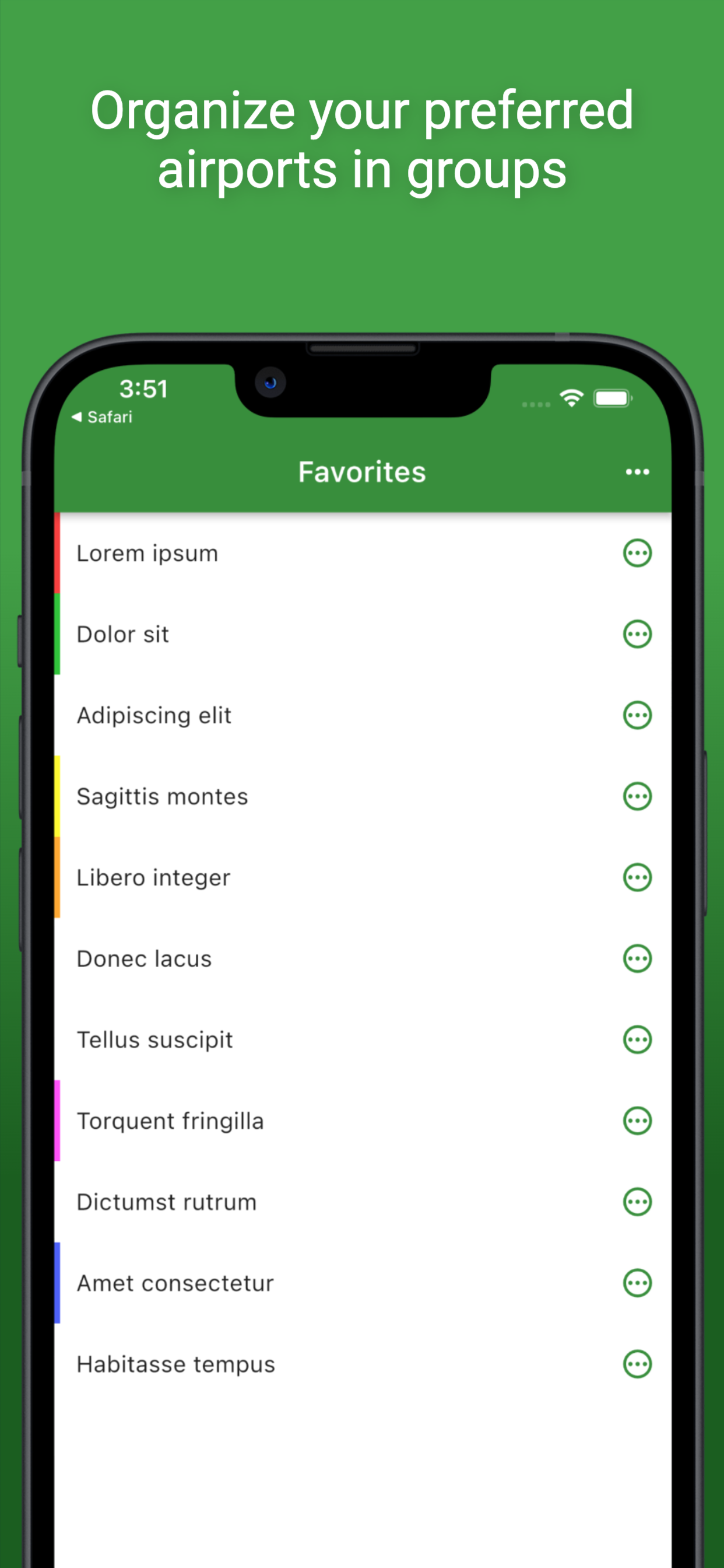
User friendly and very comprehensive App. I found it particularly useful to be able to attach your own personal notes to every airport. Easy to group your airports according to the way you want. Snowtam/runway state info are automatically decoded into simple language when weather info is displayed on the selected airport. Very useful and time saving

Great App

Holidayarmadillo on

Singapur

Good job, a very functional app! Looking forward to more features - d-atis where avail/types of approach/sat imagery/sigmet charts

Good overall app

Mach89 on

Singapur

Good overall app.

Very useful for airline pilots

Burcin Gezer on

Singapur

In addition to weather & airport data, the tools are very well thought out. Distance-Alt tool is great for non-prec approaches.

Gr8

Count.tall on

Singapur

Helpful for my work

Great app

Radialron on

Singapur

I use this daily in my work. Great app.

Weather won’t update

Shaw29 on

Vereinigtes Königreich

Since yesterday morning weather won’t update at all.

Poor update

tg198 on

Vereinigtes Königreich

Use the approach path calculator daily. Can no longer put decimal places for dme offset…….and the populated data erases if you go to another screen! WHY!

Store-Rankings

Ranking-Verlauf
App-Ranking-Verlauf noch nicht verfügbar
Kategorien-Rankings
Diagramm
Kategorie
Rang
Top Bezahlt
2
Top Bezahlt
2
Top Bezahlt
4
Top Bezahlt
8
Top Bezahlt
10

Schlüsselwörter

Airports Konkurrenten

Name
EasyMemoryItem
Train from Zero to Hero
A320 Cockpit Systems
Airbus Training & Study Guide
737 Handbook
An Interactive Technical Guide
B737 MRG
Boeing 737 handbook
B737 Performance Handbook
Performance Reference Handbook
Flyco
Aviation Learning Management
Airbus ECAM Resets+
Boeing 737 NG Exam Preparation
400+ Type Rating Questions
B737 Cockpit Companion
A320 FMS Trainer PRO
N/V

Airports Installationen

Letzte 30 Tage

Airports Umsatz

Letzte 30 Tage

Airports Einnahmen und Downloads

Gewinnen Sie wertvolle Einblicke in die Leistung von Airports mit unserer Analytik.
Melden Sie sich jetzt an, um Zugriff auf Downloads, Einnahmen und mehr zu erhalten.