AIS Maps: Marine & Lake charts

Detailed nautical & topo maps

Veröffentlicht von: Flytomap

Beschreibung

Explore a fresh perspective on the world with AIS Maps: Marine and Lakes Charts from FlyToMap. Our app is meticulously designed, offering a seamless blend of aesthetic appeal and functionality. Witness the world in intricate detail, thanks to vector-based map elements that maintain their sharpness even when zoomed in, and experience smooth panning, tilting, and rotating for a consistently immersive view.
Unlock the full potential of FlyToMap with our in-app purchase business model, providing access to a comprehensive array of maps, including Marine, Travel, Parks, and Lakes. All these maps are available for offline use at reasonable costs.
Key Features:
Live AIS:
Experience real-time map views of your boat and nearby vessels worldwide without the need for an AIS receiver—just your mobile device. Various icons denote different vessel categories, and selecting a target reveals detailed information such as name, MMSI, IMO, call sign, status, speed, heading, coordinates, distance from your GPS location, and more.
Free Features and Functions:
Latitudes and Longitudes for easy navigation
Direct search for your favorite points
Intuitive zoom, rotate, and pan with a touch
Quick object information with vector technology
GPS heading for precise navigation
Distance measurement tool for easy calculations
Route planning with real-time speed, distance, and bearing updates
Magnifying lens for detailed information
Unlimited tracks, markers, geo-tagged photos, and records
Shareable via email and visible on Google, Flytomap Viewer, and KMZ format
Depth contours selection
Background functionality for multitasking
Optimized battery usage
Local marine weather forecasts at your fingertips
Marine Maps:
Explore detailed Electronic Nautical Charts (ENC) with information on coastline, anchoring areas, fishing spots, restricted areas, obstructions, rocks, buoys, beacons, lights, depth contours, spot soundings, and more.
Lake Maps:
Access high-quality lake maps featuring depth contours, boat ramps, fishing spots, trails, roads, and railways information.
Park Maps:
Discover advanced electronic charts with hiking, biking, and equestrian trails, as well as points of interest like campgrounds, visitor centers, lookout points, eateries, ranger stations, picnic areas, boat/canoe ramps, parking areas, etc.
Travel Maps:
Explore the most captivating tourist areas, combining sea and land information for a comprehensive travel experience.
Stay connected with us:
Twitter: @flytomap
Web: flytomap.com
Facebook: facebook.com/flytomap
Embark on a journey of exploration and navigation like never before with AIS Maps: Marine and Lakes Charts by FlyToMap.
Ausblenden Mehr anzeigen...

In-App-Käufe

Oahu-Kauai
S$ 3.98
Bar Harbour
S$ 3.98
Maldives HD
S$ 3.98
Singapore HD
S$ 3.98
Columbia River
S$ 3.98
SanJana Island
S$ 3.98
Flytomap Pro HD
S$ 8.98
Phuket Island HD
S$ 3.98
Massachusetts Bay
S$ 3.98
Juan de Fuca Strait
S$ 3.98

Screenshots

AIS Maps Häufige Fragen

  • Ist AIS Maps kostenlos?

    Ja, AIS Maps ist kostenlos herunterzuladen, enthält jedoch In-App-Käufe oder Abonnements.

  • Ist AIS Maps seriös?

    🤔 Die Qualität der AIS Maps-App ist gemischt. Einige Nutzer sind zufrieden, während andere Probleme melden. Ziehen Sie in Betracht, einzelne Bewertungen für mehr Kontext zu lesen.

    Danke für die Stimme

  • Wie viel kostet AIS Maps?

    AIS Maps bietet mehrere In-App-Käufe/Abonnements, der durchschnittliche In-App-Preis beträgt 4.48 S$.

  • Wie hoch ist der Umsatz von AIS Maps?

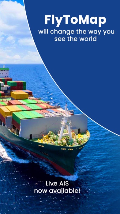
    Um geschätzte Einnahmen der AIS Maps-App und weitere AppStore-Einblicke zu erhalten, können Sie sich bei der AppTail Mobile Analytics Platform anmelden.

Benutzerbewertung
Die App ist in Singapur noch nicht bewertet.
Bewertungsverlauf

AIS Maps Bewertungen

Waste of money don’t buy

Lovelickingtammi on

Vereinigte Staaten

This apps is terrible don’t waste your money.

Great app!

Orlando_Furioso on

Vereinigte Staaten

It works well, offering all the features I need at a reasonable cost without a subscription. I particularly appreciate the weather forecast feature, which allows me to view forecasts for any location.

Garbage

The Year of the Dog on

Vereinigte Staaten

You pay then you get advertising for more pay in-app purchases…..Garbage!

Worthless. Do NOT buy!!!

sadsteve814 on

Vereinigte Staaten

Basic phone maps more useful, all functionality requires upgrade to “Pro” version

Nice charts

Ron_2000 on

Vereinigte Staaten

fishing around the keys, a good alternative free of cost by the way ..I like the weather and AIS info

Good but some Glitches

Nodak7 on

Vereinigte Staaten

I found this app very interesting. One issue is that I keep getting this banner that says they are selling the Florida Map for $1.99 but when you tap on it it takes you to a $7.99 purchase???? Also the weather is in metric with no apparent way to change it. Keep trying guys. It is promising

Worthless for MN Ice Fishing

normpete01 on

Vereinigte Staaten

Based upon all the positive reviews I downloaded the app & purchased the MN map set. The popular north metro lake I was going to fish had no contours, nothing. Looking at some lakes that had information, it was no better than the DNR maps. I removed the app after one day.

Support

jay bird29 on

Vereinigte Staaten

Awesome support

Great app!

Orlando_Furioso on

Vereinigte Staaten

It works nicely. All features I need at reasonable cost without subscription.

Works with iOS 14.7.1

Jim314159 on

Vereinigte Staaten

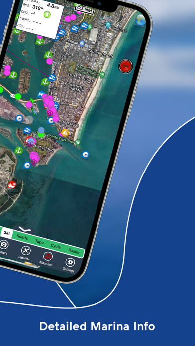
I really like the Flyto maps because you can use them with the offline maps when you are out of cell coverage. I do a lot of SCUBA diving and most of the dive sites are well out of cellphone coverage so the standard map programs are useless. There is a good marking feature so you can mark points of interest. The route function will give you bearing and ETA which is very useful.

Store-Rankings

Ranking-Verlauf
App-Ranking-Verlauf noch nicht verfügbar
Kategorien-Rankings
Diagramm
Kategorie
Rang
Top Umsatz
67
Top Umsatz
67
Top Umsatz
94
Top Kostenlos
100
Top Kostenlos
105

Schlüsselwörter

AIS Maps Konkurrenten

Name
i-Boating: Marine Charts & Gps
Lake Maps & Fishing Spots
Atlas Nautical Charts
Marine & Lakes GPS Charts
PRO CHARTS - Marine Navigation
Aqua Map Boating
Marine navigation and fishing
TZ iBoat – Marine Navigation
Boat GPS, Charts, AIS, Tides
WinGPS Marine
SeaNav
Marine Charts and Navigation
Marine Navigation Lite
Offline GPS tracker for boat
iAIS
OnCourse - boating & sailing
Navigation - mAIS

AIS Maps Installationen

Letzte 30 Tage

AIS Maps Umsatz

Letzte 30 Tage

AIS Maps Einnahmen und Downloads

Gewinnen Sie wertvolle Einblicke in die Leistung von AIS Maps mit unserer Analytik.
Melden Sie sich jetzt an, um Zugriff auf Downloads, Einnahmen und mehr zu erhalten.