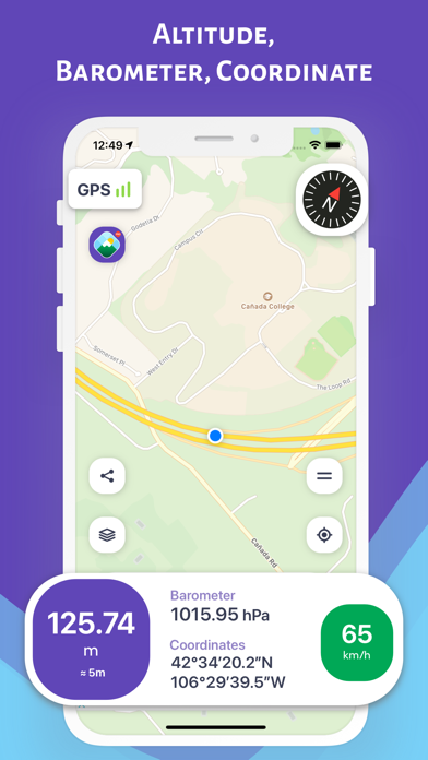
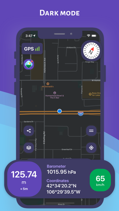
Altimeter: Elevation, Compass

Altitude Barometer GPS Tracker

Veröffentlicht von: Furkan Ozoglu

Beschreibung

While traveling with a vehicle (car, bicycle, etc.), while hiking or climbing, you can instantly discover your location and altitude, direction, geographic coordinate, address and atmospheric pressure on the map. While following your direction on a detailed compass screen, you can also monitor the change in altitude. You can share the photos you take with your loved ones, including your altitude, geographic coordinates and address information. Depending on the shooting angle, the compass direction is also included in the photos.

DISCOVER YOUR HEIGHT FROM SEA ON THE MAP (Normal Mode)
You can instantly discover the information of your location on the map
- Altitude (elevation) above sea level
- Open air (atmosphere) pressure
- Latitude and longitude coordinates and address
- Speed in motion
- Direction with a detailed compass

FOLLOW YOUR HEIGHT FROM SEA ON THE MAP ON THE MOVE (Track Mode on the Map)
On the map when traveling in a vehicle (car, bike, etc.), hiking or climbing, you can instantly track your location and the change in information
- Altitude (elevation) above sea level
- Open air (atmosphere) pressure
- Latitude and longitude coordinates and address
- Speed in motion
- Direction with a detailed compass

FOLLOW YOUR HEIGHT FROM SEA ON THE COMPASS (Compass Mode)
While traveling with a vehicle (car, bicycle, etc.), while taking a walk or climbing, you can instantly track your direction and the altitude of your current location

SHARE YOUR PHOTO WITH YOUR LOVED ONES WITH HEIGHT AND DIRECTION INFORMATION (Sharing Mode)
While traveling with a vehicle (car, bike, etc.), hiking or climbing, you can share the photos you have taken with this information
- Height, pressure, coordinate and address information will be on the photo
- Depending on the shooting angle, the compass direction will be added to the photo

YOU CAN ACCESS ALTITUDE AND LOCATION INFORMATION FROM APPLE WATCH

IMPORTANT REMINDER ABOUT CALCULATION METHOD AND ACCURACY
- The coordinates of the altitude and location are calculated using the GPS signals of the device used
- There may be differences in the measurement values ​​depending on the GPS signal quality of the device's location
- Just below the height value, the accuracy value of the measurement is given instantly in meters
- Compass accuracy may be affected by magnetic or environmental interference
Ausblenden Mehr anzeigen...

In-App-Käufe

Remove Ads
$2.99

Screenshots

Altimeter Häufige Fragen

  • Ist Altimeter kostenlos?

    Ja, Altimeter ist kostenlos herunterzuladen, enthält jedoch In-App-Käufe oder Abonnements.

  • Ist Altimeter seriös?

    ‼️️ Die Altimeter App scheint verdächtig zu sein. Viele Bewertungen wirken gefälscht oder manipuliert. Seien Sie vorsichtig.

    Danke für die Stimme

  • Wie viel kostet Altimeter?

    Altimeter bietet mehrere In-App-Käufe/Abonnements, der durchschnittliche In-App-Preis beträgt 2.99 $.

  • Wie hoch ist der Umsatz von Altimeter?

    Um geschätzte Einnahmen der Altimeter-App und weitere AppStore-Einblicke zu erhalten, können Sie sich bei der AppTail Mobile Analytics Platform anmelden.

Benutzerbewertung

4.56 von 5

25 Bewertungen in Libanon

5 star
19
4 star
4
3 star
0
2 star
1
1 star
1
Bewertungsverlauf

Altimeter Bewertungen

Güzel uygulama

Kullanıcı02.4 on

Türkei

Başarılı bir uygulama Yazılımcıya teşekkür ediyorum

Kullanıyorum

N.Bahçeci on

Türkei

Faydalı

GüZEL UYGULAMA

fbhknxxx on

Türkei

Çok güzel bir uygulama olmuş. Tebrikler…

Çok iyi

Bohumakon on

Türkei

Gerçekten çok doğru çalışıyor. Arazim 675 metre yükseklikte programda test ettiğimde 670-680 aralığında gösteriyor. Doğruya çok yakın

Çok çok iyiii tavsiye ederim

canmüzik on

Türkei

Süper

Altimetre

ahatçan on

Türkei

harika

Proğram

Sobayı yak on

Türkei

Sağlıklı çalışmıyor

ON NUMARA

Sonmezarcı on

Türkei

Çok güzel bir uygulama olmuş elinize zihninize sağlık

Güzel

turan44 on

Türkei

Güzel bir proğram emeği geçenlerin ellerine sağlık fakat biraz sorunvar gibi rakımı sabitliyemiyor örneğin 1550 vden bazen 1545 e düşüyor bazen 1555 çıkıyor

Çok güzel ve başarılı

MÜKEMMELCİ on

Türkei

Harika

Store-Rankings

Ranking-Verlauf
Kategorien-Rankings
Diagramm
Kategorie
Rang
Top Kostenlos
56
Top Kostenlos
182
Top Kostenlos
183
Top Kostenlos
223
Top Kostenlos
257

Schlüsselwörter

Altimeter Konkurrenten

Name
My Altitude
GPS Elevation & Barometer
Travel Altimeter & Elevation
Altitude, Barometer, Sea Level
Terrain Radar Altimeter
Altimeter with elevation chart
Speedometer ⊲
Limit Alert,Speed Cam,Compass
My Altitude: GPS Altimeter
Find my current altitude
Arvento
My Altitude and Elevation GPS
Elevation over surface.
Elevation - Altimeter Map
Find your altitude on the map
i Altimeter
TKGM Parsel Sorgu

Altimeter Installationen

Letzte 30 Tage

Altimeter Umsatz

Letzte 30 Tage

Altimeter Einnahmen und Downloads

Gewinnen Sie wertvolle Einblicke in die Leistung von Altimeter mit unserer Analytik.
Melden Sie sich jetzt an, um Zugriff auf Downloads, Einnahmen und mehr zu erhalten.