World Transit Maps

USA, UK & worldwide network

Veröffentlicht von: TOKYO STUDIO

Beschreibung

Well-designed railway maps integrating all railways, commuter lines and metro.
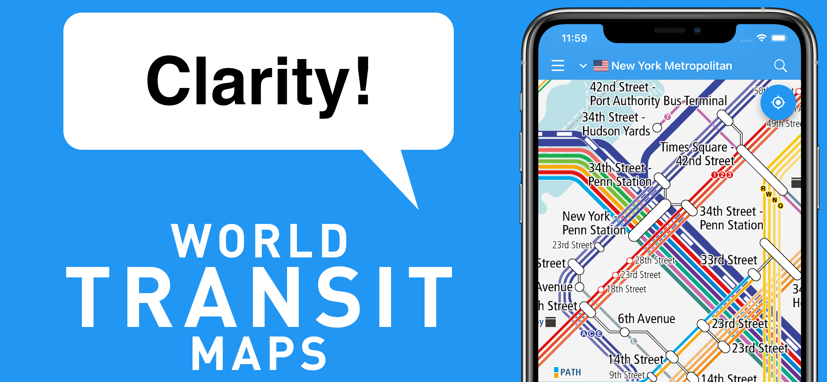
● Clarity! Railway maps
It includes all stations on all lines, such as the High-speed trains, intercity, commuter, metros, and trams with the intuitive and easy-to-understand design.
● Easy! Route finder
Tap a station on the map to add it to your route and we will propose the best route for you. Search results can be displayed at the same time as the railway map, so you won't get lost.
● Comforted! Service status
You can quickly check the service status for each line, such as suspension and delays. If you meet any troubles, you can search for an alternative route while looking at the railway map.
● Covering 10 countries / regions around the world
You can also see the world railway maps for free, which is useful for abroad travel. Great for finding access from the airport to the downtown and how to get between cities.
------------------------------
Countries / Regions
------------------------------
The coverage area will continue to expand steadily in the future.
[Asia]
- Hong Kong
MTR, Airport Express, Hong Kong Tram, Peak Tram, Light Rail
- Japan
Shinkansen, JR, railways
Subways in Tokyo, Yokohama, Nagoya, Kyoto, Osaka, Fukuoka etc.
- Malaysia
KTM, KLIA Express, KL Monorail, Kuala Lumpur LRT
- Singapore
MRT, LRT, Sentosa Express, cable car
- South Korea
KTX, KORAIL, Airport Express (A'REX)
Subways & metro in Seoul, Incheon, Daejeon, Daegu & Busan
- Taiwan
High-Speed Railway (HSR), Taiwan Railway (TRA), Alishan Forest Railway
Taipei & Kaohsiung Metro
- Thailand
State Railways (SRT), Airport Rail Link
BTS (Skytrain) & MRT in Bangkok
[Europe]
- United Kingdom
Eurostar, South Eastern High Speed, National Rail
Underground (Tube), metro, tram in London, Manchester, Newcastle etc.
- France
Eurostar, Thalys, TGV, Ouigo, Intercités, TER, Transilien, RER
Métro in Paris, Lille, Lyon, Marseille, Toulouse & Rennes
Tramway in Strasbourg, Mulhouse, Grenoble, Montpellier, Bordeaux, Nantes, Caen etc.
[North America]
- United States
Amtrak, Bright Line, Alaska Railroad, Metro-North Railroad, Long Island Rail Road, PATH, NJ Transit, SEPTA, Metra, New York City Subway, CTA in Chicago, RTD in Denver, Los Angeles Metro, Muni Metro in San Francisco etc.
------------------------------
Major Functions
------------------------------
- Railway maps for multiple languages
(Offline browsing is available if already downloaded)
- Transit route search
- Service status
- Street maps
- Hotel reservation
- Timetable of stations (Japan Only)
- Photo gallery of stations
------------------------------
Upgrade
------------------------------
You can now use the railway maps and the transit route search of all provided countries / regions with regardless of the free / paid plan.
“Rail Map Basic” (Free)
- You need to watch a video ad when switching between countries / regions.
- The railway maps or other screens show ads.
“Rail Map Passport” (One-time-purchase)
- Fast Lane: Video ads are not displayed when switching between countries / regions.
- The railway maps or other screens show ads.
“Rail Map Premium” (Monthly Subscription)
- Fast Lane: Video ads are not displayed when switching between countries / regions.
- Ads are disappeared on the railway maps or other screen *1.
*1 Some ads may be shown on the screen such as the result of transit route search or others.
Ausblenden Mehr anzeigen...

In-App-Käufe

Forever
د.إ.‏ 14.99
Subscription / Monthly
د.إ.‏ 6.99
One time / Valid for 7 days
د.إ.‏ 2.99

Screenshots

World Transit Maps Häufige Fragen

  • Ist World Transit Maps kostenlos?

    Ja, World Transit Maps ist kostenlos herunterzuladen, enthält jedoch In-App-Käufe oder Abonnements.

  • Ist World Transit Maps seriös?

    🤔 Die Qualität der World Transit Maps-App ist gemischt. Einige Nutzer sind zufrieden, während andere Probleme melden. Ziehen Sie in Betracht, einzelne Bewertungen für mehr Kontext zu lesen.

    Danke für die Stimme

  • Wie viel kostet World Transit Maps?

    World Transit Maps bietet mehrere In-App-Käufe/Abonnements, der durchschnittliche In-App-Preis beträgt 8.32 د.إ.‏.

  • Wie hoch ist der Umsatz von World Transit Maps?

    Um geschätzte Einnahmen der World Transit Maps-App und weitere AppStore-Einblicke zu erhalten, können Sie sich bei der AppTail Mobile Analytics Platform anmelden.

Benutzerbewertung

3.5 von 5

4 Bewertungen in Vereinigte Arabische Emirate

5 star
2
4 star
0
3 star
1
2 star
0
1 star
1
Bewertungsverlauf

World Transit Maps Bewertungen

Great App to use when in Japan

Ms. Piggs on

Vereinigte Arabische Emirate

I am currently travelling in Japan with my sinlings and this helps me us not to get lost. This app specifies which platform to be at. And how much the fare is going to be. It gives you 4 different routes for fastest cheapest and easy routes to take. A must app while travelling in japan.

一つ改善

柴犬no1 on

Japan

Androidバージョンでは駅を検索すると赤ピンで検索駅が表示されるがiOSバージョンでは路線図中央近辺に表示されて非常に見にくい 同じ様に赤マークで表示されれば良い

兎に角宣伝の案内が多過ぎる

+2☆ on

Japan

全ての宣伝がWEBに繋がるので全て見れず何件未読か数字でアイコンに表示されるのかいやだ

カラフルで良い

わやてほは on

Japan

路線図は、とてもカラフルで見やすい 縮小ができない

かなり分かり易い

あしかたし on

Japan

路線図は整理されててかなり良いが地方ごとに分割されてるところが微妙。紙じゃないんだから一面にまとめて欲しい。

ダウンロードの意味がない

barisaku on

Japan

とても見やすいアプリであるが、いざ使おうとするとダウンロードしたデータが無くなっていて、またダウンロードし直すことになることが多い。多すぎる。わざわざダウンロードした意味がないと思う。

私鉄特急

ebi大好き on

Japan

私鉄の特急の名前がない

便利

ヒロゴニロウ on

Japan

遠方に出る時よく使います。 評価は星4 拡大が自由に制限無く使えれば最高ですが、フォント都合で限度^_^あるのでしょうか。 とくに良いのは、現在走行している乗車電車の最寄り駅はどこかがボタン一発で分かるところ。

見やすいけど……

hazuzufuma on

Japan

調べやすいし、カラフルで見やすくていいんですけど、アプリを閉じるたびに広告が入ってうざいです( ; ; )

表示できる範囲について

お麩ちゃん on

Japan

iPhoneで表示する際、画面に表示できる範囲が狭すぎるのを改善して欲しい。(もっと縮小できるようにして欲しい) 例えば山手線を一画面内に表示することができない。 AndroidだとこのようなことにはならないのになぜiPhoneだとこんなに狭い範囲しか表示できないのか… 一応iPadなら多少は広く表示できるが… それ以外は不満なし。 理想を言うなら地域ごとではなく全国の路線図を繋げて見たいが、レイアウトの問題などで仕方ないかと思う。

Store-Rankings

Ranking-Verlauf
App-Ranking-Verlauf noch nicht verfügbar
Kategorien-Rankings
Diagramm
Kategorie
Rang
Top Umsatz
23
Top Umsatz
35
Top Umsatz
45
Top Kostenlos
241
Top Kostenlos
356

Schlüsselwörter

World Transit Maps Konkurrenten

Name
MetroMan Taipei
Taipei Transit Planner
City Rail Map - Travel Offline
Transit for Subway Metro Train
Journey Planner / Map -Transit
70+ cities in Asia & Europe
Japan Travel - Route,Map,Guide
Visit Japan: Ultimate Planner
JR東海 東海道・山陽新幹線時刻表
Tokyo Subway Map OFFLINE
N/V
tokyo metro transit map
tokyo metro navigation map
NUUA METRO- Offline Subway Map
France/UK/Japan/Korea Transit
MetroMan Japan
Japan Transit Planner
日本换乘-去日本旅行必备交通乘换工具
覆盖地铁电车巴士JR新干线

乗換路線図 Installationen

Letzte 30 Tage

乗換路線図 Umsatz

Letzte 30 Tage

World Transit Maps Einnahmen und Downloads

Gewinnen Sie wertvolle Einblicke in die Leistung von 乗換路線図 mit unserer Analytik.
Melden Sie sich jetzt an, um Zugriff auf Downloads, Einnahmen und mehr zu erhalten.

App-Informationen