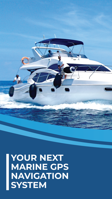
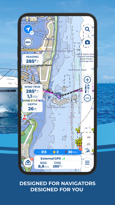
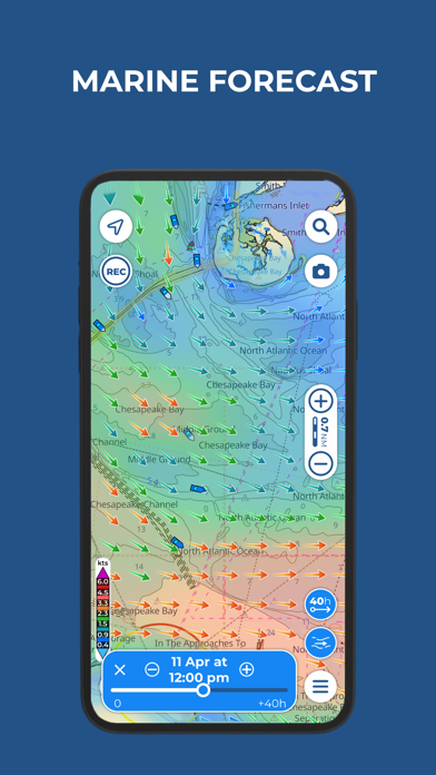
Aqua Map Boating

Marine navigation and fishing

Veröffentlicht von: GEC s.r.l

Beschreibung

Free trial available for all subscriptions
Aqua Map offers OFFICIAL NAUTICAL CHARTS (UKHO) for marine navigation. Purchase a chart subscription for the area of your interest, download the map areas for offline use, and connect your onboard instruments for a complete experience.

● BASIC FEATURES
- Overlay satellite images on the charts
- Manually create your route and record your track
- Store and share your navigation data (markers, routes, and recorded tracks)
- Increase your safety with Anchor Alarm
- Enable Live Sharing to interact with the Aqua Map community
- Display points of interest from the "ActiveCaptain" and "Waterway Guide" communities

● EXPERT SUBSCRIPTION
Note: this subscription does not include charts; it must be paired with a chart subscription.
- Marine forecasts (wind, waves, currents, gusts, salinity, sea surface temperature + weather information for any point on the map)
- Advanced AnchorLink with anchorage mirroring and email/telegram notifications for greater peace of mind while anchored, even if you are away from the boat
- Connect your NMEA instruments via WiFi (autopilot, depth sounder, wind sensor, compass, GPS) and use their data on the app
- AIS with automatic collision detection
- Route Explorer for real-time information on all elements along your route 

● PURCHASE OPTIONS
To access the charts, you need to purchase a chart subscription for the area of interest. Optionally, you can add the Expert subscription to unlock extra navigation features. Subscription payments will be made through your account (Apple ID). The annual subscription will automatically renew unless canceled at least 24 hours before expiration. You can manage your subscription and disable automatic renewal in the account settings section after purchase.

Terms of use: https://www.aquamap.app/terms-and-conditions
Privacy policy: https://www.aquamap.app/privacy-policy
Ausblenden Mehr anzeigen...

In-App-Käufe

France - charts
₹ 1,949
Mexico - West coast
₹ 6,900
Atlantic France - charts
₹ 1,149
Northern France - charts
₹ 1,149
Norway - Nautical charts
₹ 2,299
StrikeLines HardBottomHD
₹ 69,900
Iceland - nautical charts
₹ 1,999
Mexico - Pacific Mainland
₹ 3,349
Cape Verde - Nautical charts
₹ 1,299

Screenshots

Aqua Map Boating Häufige Fragen

  • Ist Aqua Map Boating kostenlos?

    Ja, Aqua Map Boating ist kostenlos herunterzuladen, enthält jedoch In-App-Käufe oder Abonnements.

  • Ist Aqua Map Boating seriös?

    🤔 Die Qualität der Aqua Map Boating-App ist gemischt. Einige Nutzer sind zufrieden, während andere Probleme melden. Ziehen Sie in Betracht, einzelne Bewertungen für mehr Kontext zu lesen.

    Danke für die Stimme

  • Wie viel kostet Aqua Map Boating?

    Aqua Map Boating bietet mehrere In-App-Käufe/Abonnements, der durchschnittliche In-App-Preis beträgt ₹10.00.

  • Wie hoch ist der Umsatz von Aqua Map Boating?

    Um geschätzte Einnahmen der Aqua Map Boating-App und weitere AppStore-Einblicke zu erhalten, können Sie sich bei der AppTail Mobile Analytics Platform anmelden.

Benutzerbewertung

5 von 5

2 Bewertungen in Indien

5 star
2
4 star
0
3 star
0
2 star
0
1 star
0
Bewertungsverlauf

Aqua Map Boating Bewertungen

Too money hungry

Michigan Outdoorsman on

Vereinigte Staaten

They charge too much and are too money hungry.

A Top Notch App

7-6 & Bo Pilot on

Vereinigte Staaten

I am cruising the Great Loop in sections in a 2012 Ranger Tug R27. The chartplotter on my boat is a legacy Garmin 5212. I use the chart plotter for a radar and sonar display and navigate with Aqua Maps on an iPad Pro 12.9”. For redundancy, I carry two iPad Pros. Aqua Maps is well thought out and continuous improvements are made. It is easy to use and information is easy to access. Charts are easy to select, download and update. The developers respond quickly to email support inquiries. I highly recommend this application.

Better than on-boat plotters

Exivus on

Vereinigte Staaten

Just like ForeFlight is a modern necessity for flying, this is THE app for boating. Hope it NEVER changes!!

Another nickel and dime to death app

captain AppleBoy on

Vereinigte Staaten

I absolutely loathe being nickel and dimed, and I hate this modern paradigm of “subscription“ every goddamned thing. I may not sail for two years, but when I go out I want the CHARTS and MAPS to still be charts and maps, not some scrambled data that’s unusable until I throw more money at a company that may not even exist at that point. AAARGH! I love the companies that give us the option to just BUY something, and OWN it. This program does not appear to be one of those. If I’m wrong, and the option to BUY this exists somewhere, I will come back and re-review.

tap and download updates

msw611 on

Vereinigte Staaten

I am not crazy about how you tap and download updates on the tiles anymore. I prefer the old way.

Kept us safe!!!

Dsmrossi on

Vereinigte Staaten

I’ve had Aquamap for many years now. Went on a fishing trip off the coast of Block Island last night with my buddies. While the water was flat, we were in THICK fog all night. We used the app to get home in conditions boats loaded with electronics didn’t venture out in. We wouldn’t have made it in otherwise. The currents were moving FAST and pushing the bow all over the place. Being able to plot our heading and make continuous adjustments was critical. Only thing - and it may just be my phone - is that if you stop for a bit it doesn’t immediately register where your bow it pointed, you need to get going approx 10kts or so before you get an accurate “pointer”. Thank you!!!

Download

RapidStang on

Vereinigte Staaten

I have learned that there is a way to control the timing of the tile downloads. If you are getting interrupted by this, there’s a way to adjust the timing of downloads in Sertings, what a great app.!

Value

sandbarbill on

Vereinigte Staaten

While driving our boat up the ICW our Simrad chart plotter died. Aqua Map saved our butts. Great app whuch along with Waterway guide made our 1000 mile journey much safer and relaxing. Wont leave port without it.

Was on passage and the update killed it

Doubloh on

Vereinigte Staaten

Don’t update it!! Now stuck in a endless crash loop after entering in a lat/long in the search bar. Unfortunately Apple won’t let me downgrade to the old version so I would have access to charts so I can get home.

Wonderful app

Scooter-boat on

Vereinigte Staaten

We use on 4 devices. Our favorite navigation tool.

Store-Rankings

Ranking-Verlauf
Kategorien-Rankings
Diagramm
Kategorie
Rang
Top Umsatz
10
Top Umsatz
26
Top Umsatz
39
Top Umsatz
54
Top Umsatz
56

Schlüsselwörter

Aqua Map Boating Konkurrenten

Name
iNavX: Marine Navigation
Sailing & Boating Chartplotter
Navionics® Boating
Nautical and fishing charts
C-MAP: Boating
Charts, Planning & Navigation
i-Boating: Marine Charts & Gps
Lake Maps & Fishing Spots
Atlas Nautical Charts
Marine & Lakes GPS Charts
savvy navvy: Boat Navigation
GPS Charts Tide Weather AIS
PRO CHARTS - Marine Navigation
ActiveCaptain®
Connect to Your GPS Plotter
TZ iBoat – Marine Navigation
Boat GPS, Charts, AIS, Tides
Dockwa
Dock and mooring reservations

Aqua Map Boating Installationen

Letzte 30 Tage

Aqua Map Boating Umsatz

Letzte 30 Tage

Aqua Map Boating Einnahmen und Downloads

Gewinnen Sie wertvolle Einblicke in die Leistung von Aqua Map Boating mit unserer Analytik.
Melden Sie sich jetzt an, um Zugriff auf Downloads, Einnahmen und mehr zu erhalten.