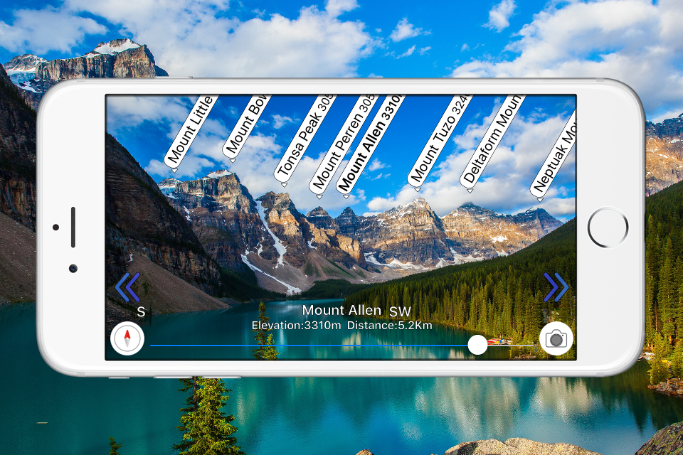
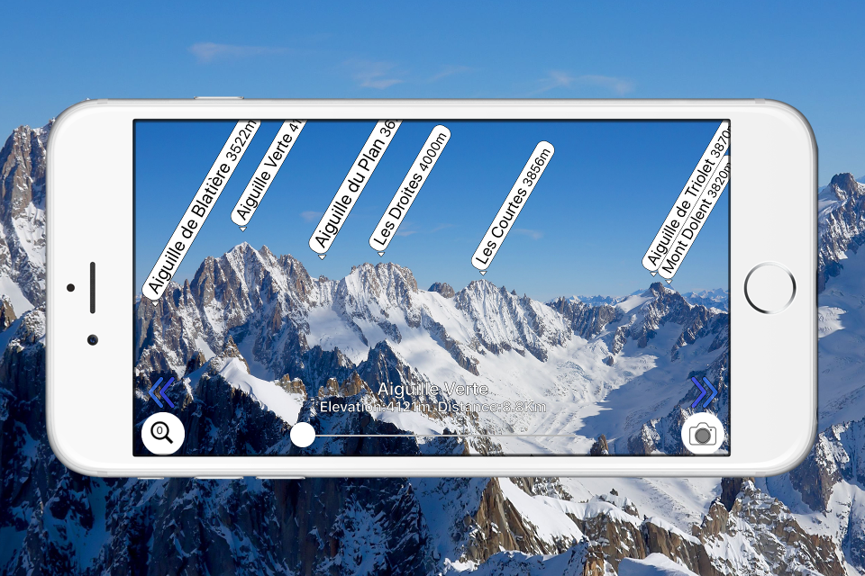
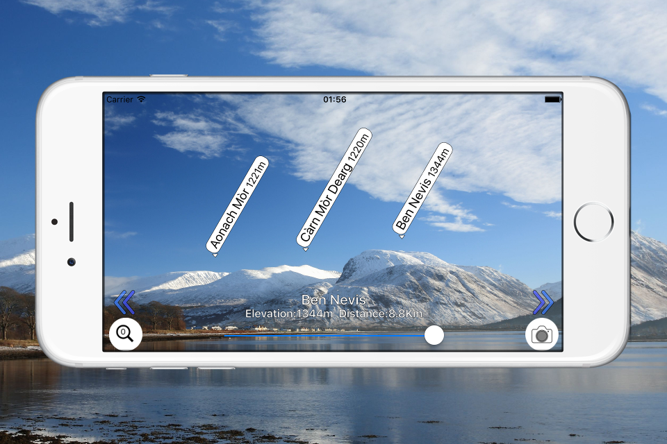
AR AlpineGuide

Veröffentlicht von: Noriyoshi Tsunashima

Beschreibung

Point your iOS device at the mountain and you'll see the name, altitude, and distance of the mountaintop.
You can identify the names of all the mountain peaks in the 360-degree panoramic AR view.
All features are free to use.
Over 1 million downloads total for all platforms!
Features
- It has data from nearly one million peaks around the world.
- It uses three-dimensional coordinates and a gyroscope to display the name at the peak, even if you tilt the camera. The display makes it easy to check.
- The three-dimensional terrain is displayed semi-transparently, so it is easy to compare it with the actual shape of the mountain and check the location of the peak.
- When you point your iOS device downward, the view switches to a 3D view looking down from the sky.
- You can check the names of the terrain and mountains that can be seen from any location specified on the map.
- You can take a photo with the name of the peak and share it via SNS or email.
- Swiping the AR display up, down, left, or right allows you to adjust the position of the peak name display.
- It is possible to adjust the position of the peak name display after the picture is taken.
- You can import photos taken with another app and add the peak name.
- All the features are free!

※ If the direction is not correct (e.g. it always shows North), if your iOS device has a cover on it If there is a sensor in the case, please remove it. The metal or magnet on the cover may interfere with the sensor and cause it to malfunction.

Terms of Service
https://www.apple.com/legal/internet-services/itunes/dev/stdeula/
Ausblenden Mehr anzeigen...

In-App-Käufe

Ad-Free
£0.99

Screenshots

AR AlpineGuide Häufige Fragen

  • Ist AR AlpineGuide kostenlos?

    Ja, AR AlpineGuide ist kostenlos herunterzuladen, enthält jedoch In-App-Käufe oder Abonnements.

  • Ist AR AlpineGuide seriös?

    🤔 Die Qualität der AR AlpineGuide-App ist gemischt. Einige Nutzer sind zufrieden, während andere Probleme melden. Ziehen Sie in Betracht, einzelne Bewertungen für mehr Kontext zu lesen.

    Danke für die Stimme

  • Wie viel kostet AR AlpineGuide?

    AR AlpineGuide bietet mehrere In-App-Käufe/Abonnements, der durchschnittliche In-App-Preis beträgt £0.99.

  • Wie hoch ist der Umsatz von AR AlpineGuide?

    Um geschätzte Einnahmen der AR AlpineGuide-App und weitere AppStore-Einblicke zu erhalten, können Sie sich bei der AppTail Mobile Analytics Platform anmelden.

Benutzerbewertung

4.67 von 5

21 Bewertungen in Vereinigtes Königreich

5 star
18
4 star
1
3 star
1
2 star
0
1 star
1
Bewertungsverlauf

AR AlpineGuide Bewertungen

很實用

李清寸 on

Taiwan

讚👍

問一下

臺灣加油🇹🇼 on

Taiwan

請問要怎麼打開鏡頭

無法拍照留存

陳翰德 on

Taiwan

點選拍照後就當機!

A Very Good App for Mountain Lovers

dontcallmefornothing on

Taiwan

I downloaded this app for free. However, there’s Chinese mountain names (And I haven’t found the names incorrect) and friendly interface. The AR is working but not very accurate and hasn’t succeed to show correct figures if I opened this app within mountains. This app worked perfectly when I am at around sea attitude with some manual adjustment (the direction wasn’t right so moved by hand. I think it’s due to the accuracy of my iPhone built-in compass). Any way it is a recommended app for those who loves mountains.

狂閃退

gstatong on

Taiwan

如標題

更新後影像變綠頻

ChangdaChen on

Taiwan

更新後影像變綠頻

閃退

Jackal tai on

Taiwan

點選拍照後要按儲存就閃退

更新2.22版後閃退

JackieLee0925 on

Taiwan

如標題

閃退

阿龐337 on

Taiwan

如標題,一直閃退

照相後存檔會當機

Qpbl on

Taiwan

麻煩修正

Store-Rankings

Ranking-Verlauf
Kategorien-Rankings
Diagramm
Kategorie
Rang
Top Kostenlos
74
Top Umsatz
77
Top Kostenlos
80
Top Kostenlos
91
Top Kostenlos
119

AR AlpineGuide Konkurrenten

Name
PeakFinder
The mountains are calling!
Maps 3D - Hike & Bike
GPS for Bike, Hike & Ski
ASFINAG
SwitzerlandMobility
Non-motorized traffic network
Terra Map - Trail Explorer
Outdoor trails & topo charts
bergfex: hiking & tracking
Tour planner & GPS navigation
Hiking Maps - PeakVisor
Peak Finder 3D / AR
Outdooractive
Reliable planning & navigation
alpenvereinaktiv
Tourenportal der Alpenvereine
Swiss3D
Peak detection

AR山地圖 Installationen

Letzte 30 Tage

AR山地圖 Umsatz

Letzte 30 Tage

AR AlpineGuide Einnahmen und Downloads

Gewinnen Sie wertvolle Einblicke in die Leistung von AR山地圖 mit unserer Analytik.
Melden Sie sich jetzt an, um Zugriff auf Downloads, Einnahmen und mehr zu erhalten.

App-Informationen