能不能恢复一下。
我觉得还行,比较接近,谷歌地球,不会还差远了,你这个地图啊,还在升级升级+1节3D功能,再把这个国家的名字给他标出来。


Ja, ArcGIS Earth ist komplett kostenlos und enthält keine In-App-Käufe oder Abonnements.
🤔 Die Qualität der ArcGIS Earth-App ist gemischt. Einige Nutzer sind zufrieden, während andere Probleme melden. Ziehen Sie in Betracht, einzelne Bewertungen für mehr Kontext zu lesen.
ArcGIS Earth ist kostenlos.
Um geschätzte Einnahmen der ArcGIS Earth-App und weitere AppStore-Einblicke zu erhalten, können Sie sich bei der AppTail Mobile Analytics Platform anmelden.

5 von 5
1 Bewertungen in Kasachstan
我觉得还行,比较接近,谷歌地球,不会还差远了,你这个地图啊,还在升级升级+1节3D功能,再把这个国家的名字给他标出来。
不能用14pro
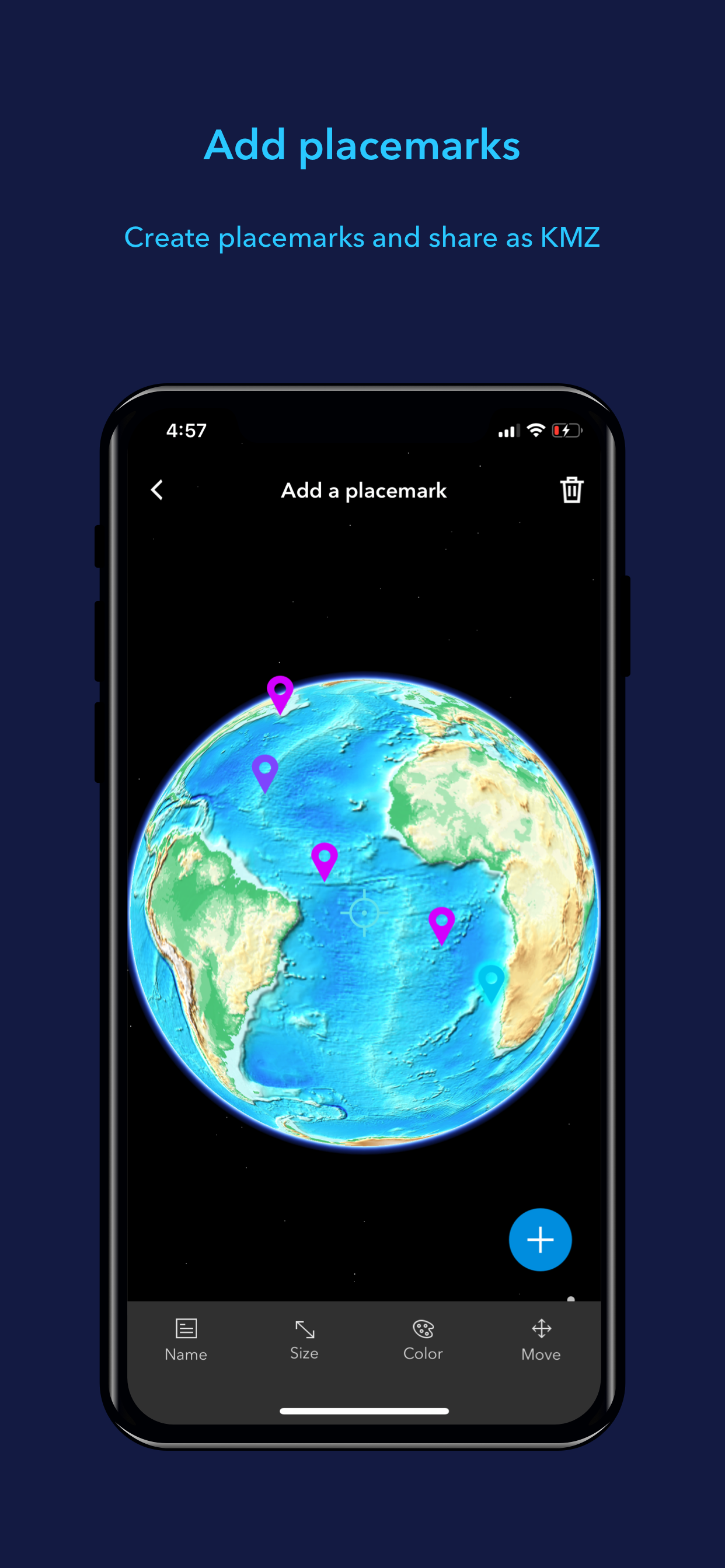
移动场景包和场景图层包是怎么制作的?
更新了最新版本,打开地图放大到最大后,一小会就自己退出了,不知道什么问题(没更新之前是没有这种情况的,手机系统最新版本)
为什么底图服务没了?
有点着急呀
好看。
英文看着很累啊 能不能出中文啊累晕
英语差的使用费劲
在线图源强大,界面功能比较欠缺。文件文件加载上对arcgis导出的文件支持的比较少。离线图源能不能加上显隐比例尺范围和透明度设置呢?
|
Diagramm
|
Kategorie
|
Rang
|
|---|---|---|
|
Top Kostenlos
|

|
240
|
|
Top Kostenlos
|

|
327
|
| Name | Downloads (30d) | Monatlicher Umsatz | Rezensionen | Bewertungen | Letzte Veröffentlichung | |
|---|---|---|---|---|---|---|

ZWCAD Mobile - Mobile CAD
DWG viewer and editor
|
Freischalten
|
Freischalten
|
0
|
1
|
vor 1 Woche | |

My GPS Coordinates
|
Freischalten
|
Freischalten
|
0
|
|
vor 2 Jahren | |

GIS Lite
Explore space
|
Freischalten
|
Freischalten
|
0
|
|
vor 5 Monaten | |

GIS4Mobile
Recording is rewarding
|
Freischalten
|
Freischalten
|
0
|
|
vor 2 Wochen | |

DWG Tools - View & Convert DWG
View and convert CAD drawings
|
Freischalten
|
Freischalten
|
0
|
|
vor 9 Monaten | |

ARES Touch: DWG Viewer & CAD
Read, Modify & Annotate in DWG
|
Freischalten
|
Freischalten
|
0
|
|
vor 1 Monat | |

Mobile Data Collection
Collect using custom forms
|
Freischalten
|
Freischalten
|
0
|
|
vor 2 Monaten | |

QField for QGIS
Efficient field work for QGIS
|
Freischalten
|
Freischalten
|
1
|
|
vor 2 Wochen | |

Luban Ruler - Lucky Ruler
|
Freischalten
|
Freischalten
|
0
|
|
vor 2 Jahren | |

DJI GS Pro
|
Freischalten
|
Freischalten
|
0
|
|
vor 1 Jahr |
