Atlas Nautical Charts

Marine & Lakes GPS Charts

Veröffentlicht von: MapITech

Beschreibung

Mapitech launches Atlas, a worldwide digital cartography that combines vector data with the best official up-to-date paper charts ie marinas, depth contours, wrecks, fishing spots, boat ramps, POI and many other features.
The beauty of paper charts enriched with digital cartography.
Chart details and performance of a professional GPS chart plotter in the palm of your hand.
Appealing appearance, easy to use, useful to have on board with you.
The app works without mobile coverage (offline).
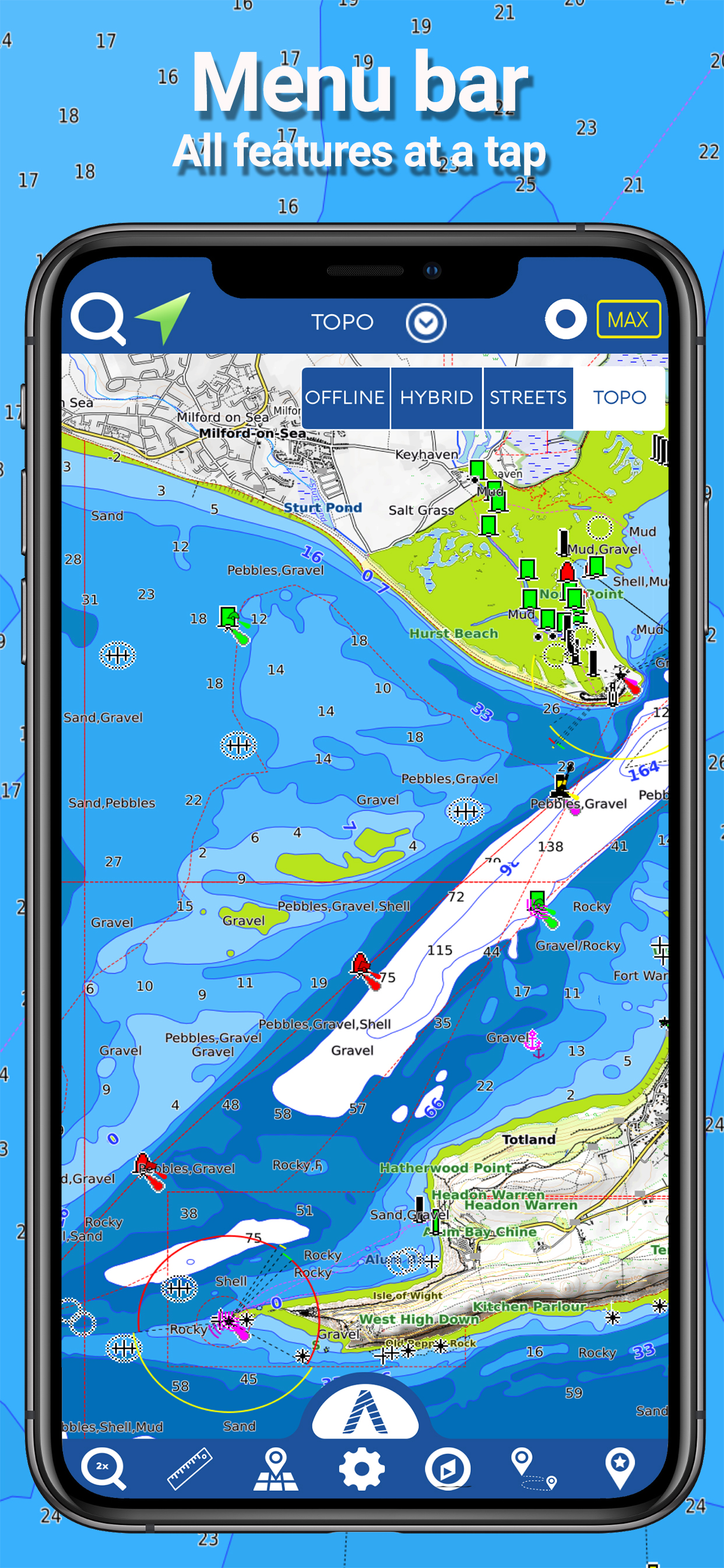
The interactive menu is intuitive and allows you to purchase maps for offline use at an amazing price.
Free Features and Functions:
•Powerful search
•Multiple overlays for different use (fishing, sailing or cruising)
•KML data shareable
•Very detailed and updated charts
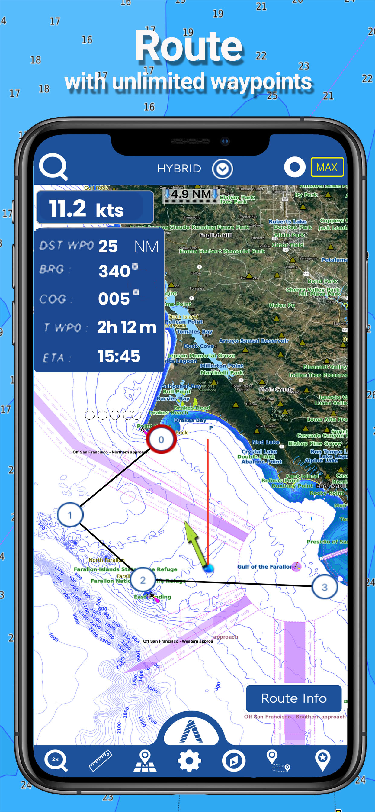
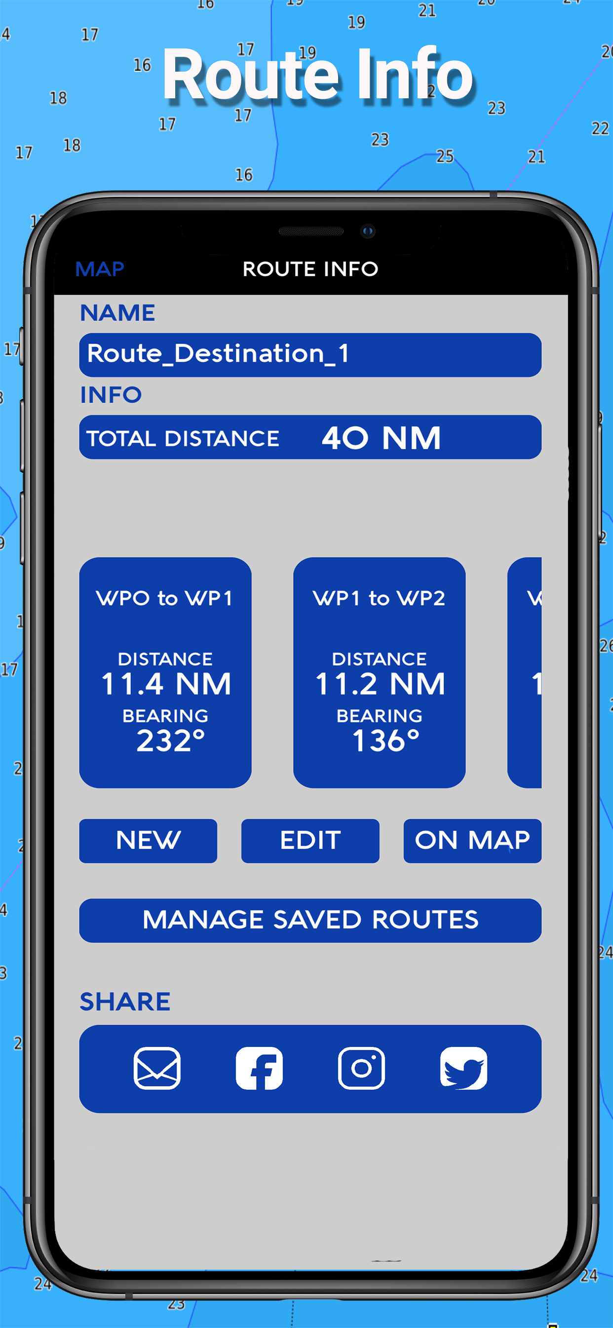
•Unlimited Waypoints
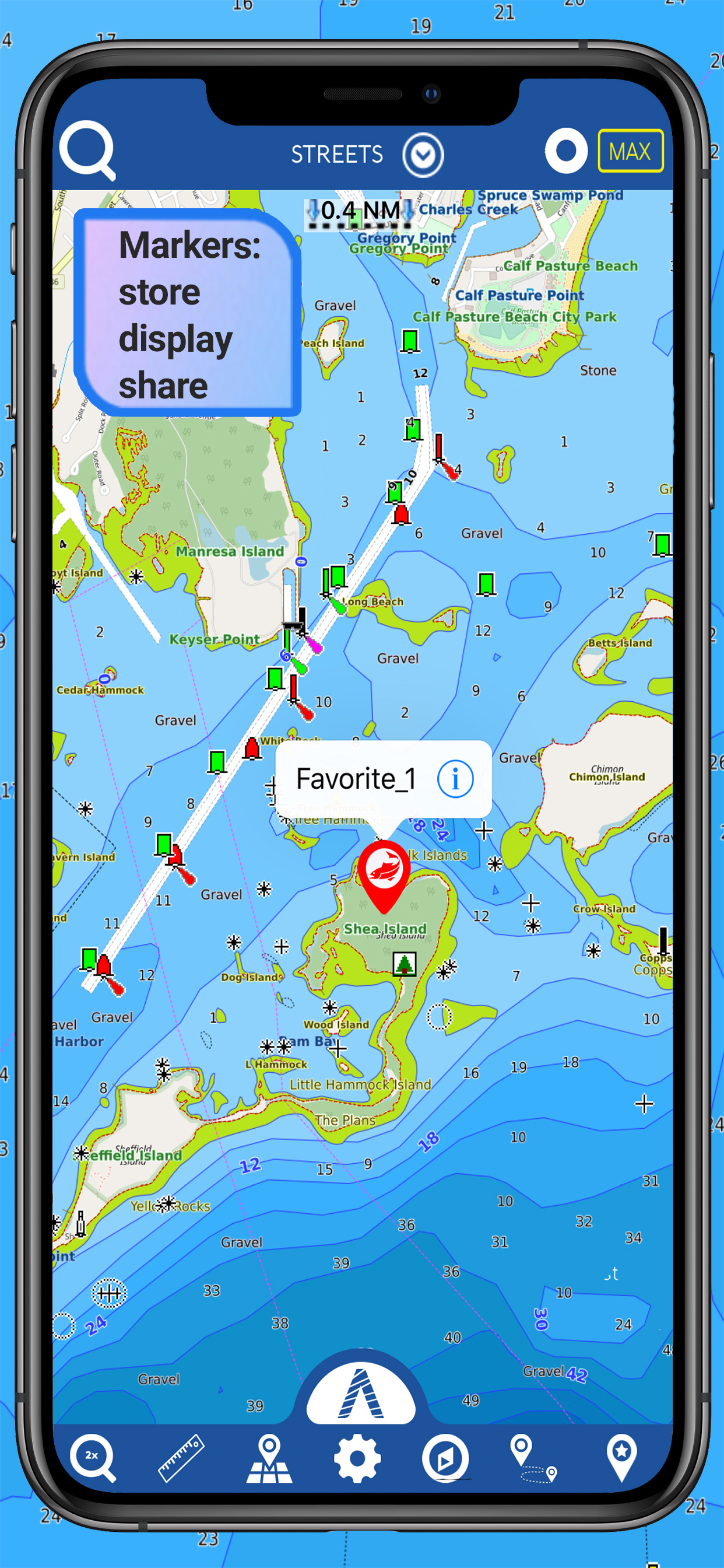
•Markers & Favorites
•Magnifying Lens for all info
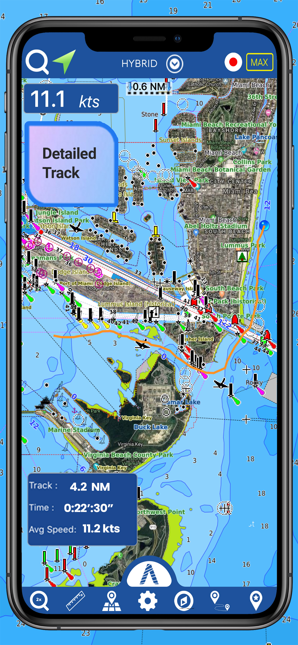
•Multiple tracks: Record your track, instant speed time, COG - course over ground
•Route planning, Waypoints - Insert the destination and see in real time your speed, distance and bearing
•Geo-tagged photo management, Share via email, visible on Google
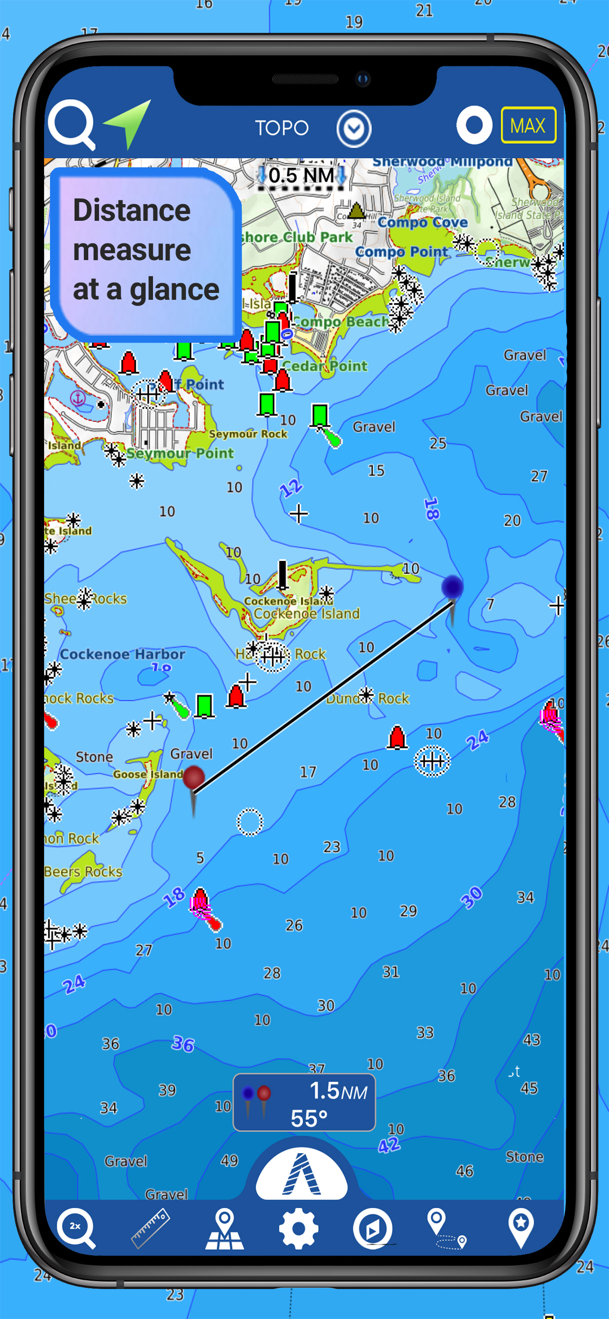
•Distance Measurement Tool to easily calculate the distance
•Compass
•GPS window with very detailed info
•User friendly on latest IOS
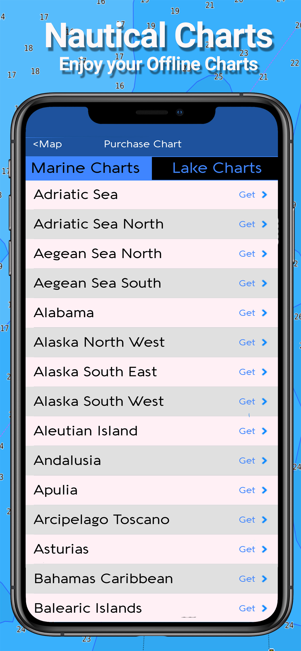
- MARINE MAPS
Detailed Electronic Nautical Charts (ENC) which include Coastline, Anchoring areas, Fishing areas, Restricted areas, Obstructions, Rocks, Buoys, Beacons, Lights, Depth contours, Spot Soundings and more.
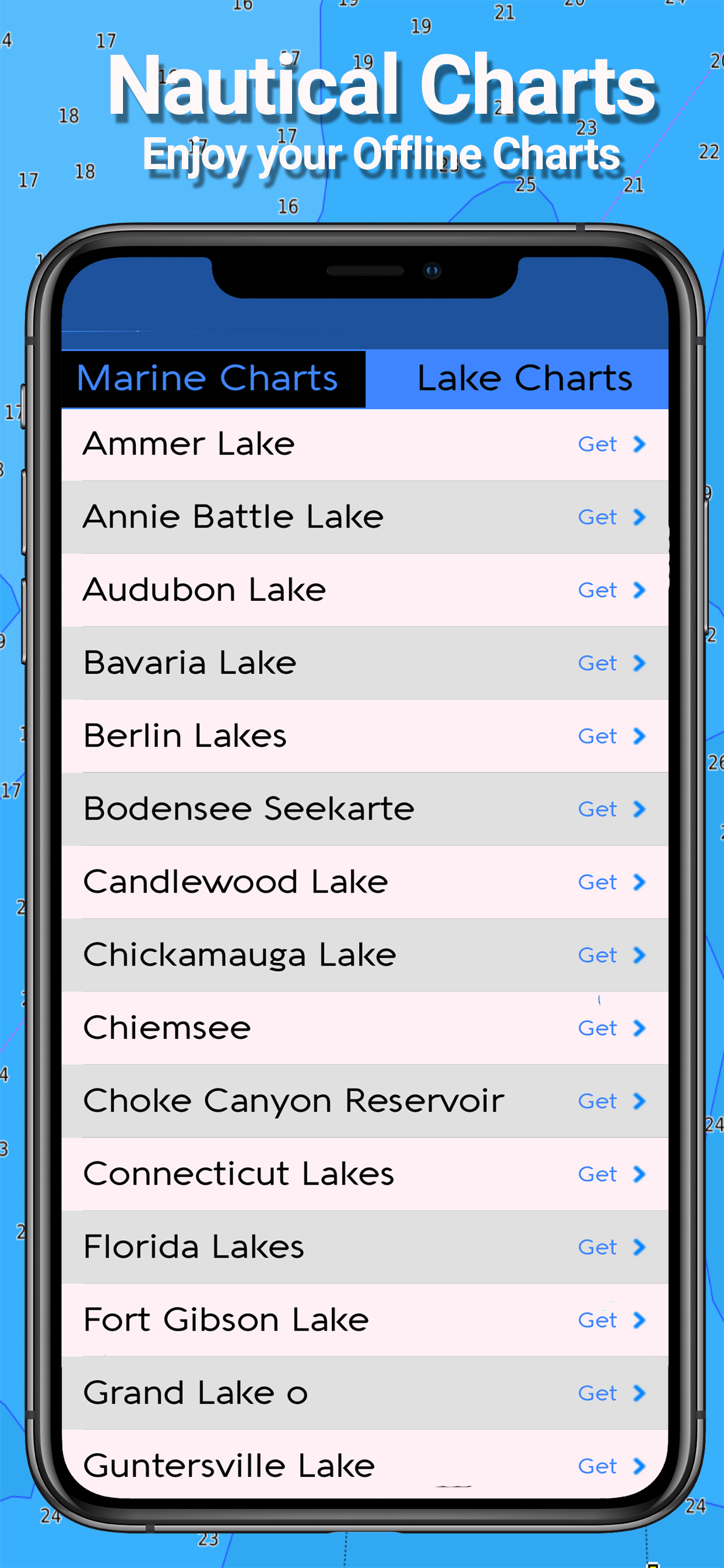
- LAKE MAPS
High quality lake maps with detailed information and important features: Depth Contours, Boat Ramps, Fishing spots etc. Maps also include Trails, Roads and Railways information.
PURCHASING INCLUDES:
•Offline Chart: Choose your favorite area from our catalogue and get a detailed chart of your area
•Subscription for 1 year: Get a trial of all our charts and features and subscribe for one year
•Lifetime Purchase: Get all our charts and features for Lifetime
MORE INFO:
Terms of Use: https://mapitech.com/disclaimer/
Privacy Policy: https://mapitech.com/privacy-policy/
Ausblenden Mehr anzeigen...

In-App-Käufe

George's Bank
19,99 zł
Africa basemap
0,00 zł
Europe basemap
0,00 zł
Albemarle Sound
19,99 zł
Black Bay Houma
19,99 zł
Florida South West
19,99 zł
Worldwide basic map
0,00 zł
Cape Elizabeth to Cape Ann
19,99 zł
All charts lifetime download
99,99 zł
All charts 1 year subscription
44,99 zł

Screenshots

Atlas Nautical Charts Häufige Fragen

  • Ist Atlas Nautical Charts kostenlos?

    Ja, Atlas Nautical Charts ist kostenlos herunterzuladen, enthält jedoch In-App-Käufe oder Abonnements.

  • Ist Atlas Nautical Charts seriös?

    Nicht genügend Bewertungen, um eine zuverlässige Einschätzung vorzunehmen. Die App benötigt mehr Nutzerfeedback.

    Danke für die Stimme

  • Wie viel kostet Atlas Nautical Charts?

    Atlas Nautical Charts bietet mehrere In-App-Käufe/Abonnements, der durchschnittliche In-App-Preis beträgt 24.49 zł.

  • Wie hoch ist der Umsatz von Atlas Nautical Charts?

    Um geschätzte Einnahmen der Atlas Nautical Charts-App und weitere AppStore-Einblicke zu erhalten, können Sie sich bei der AppTail Mobile Analytics Platform anmelden.

Benutzerbewertung

3 von 5

1 Bewertungen in Polen

5 star
0
4 star
0
3 star
1
2 star
0
1 star
0
Bewertungsverlauf

Atlas Nautical Charts Bewertungen

Inexpensive maps for sailors, often lacking details

Mroovak on

Polen

You get what you pay for. It's a combination of raster and vector maps, but depending where you go - they often lack important details and so are not really useful for detailed route planning and navigation. Also the app is rather slow. Once you download a map, there's no way of removing it from device memory.

Atlas charts

Jlpetz on

Vereinigte Staaten

Good app. Great customer service.

The worst app

I Love Whail Trail on

Vereinigte Staaten

I’ve been looking for a nautical chart for so long and i tried this one and just gave up on it I downloaded a map and it kept telling me I needed to download one and then it wouldn’t load in 5 minutes so I just gave up don’t even try it

Nice chart

Ron_2000 on

Vereinigte Staaten

Great update. Finally I can go fishing

The Best App to test your patience and empty your wallet.

even a review is dificult on

Vereinigte Staaten

The app has great potential. HOWEVER, it never works accurately, it lags, customer service is non existent, etc. I paid for the premium version to see it the program would improve. The only thing that improved was the company’s wallet. Reaching out to them was an exercise in futility. So, as a result, I will go out of my way to ensure that whoever I can reach will know not to waste money or effort. Had the company at least be responsive, I would have reconsidered. But the lack of effort shows in their work all throughout. From client services to application programming.

Dysfunctional App

PatteKnight on

Vereinigte Staaten

I paid $3.99 for the APP and when Attempted to zoom into the lake I’m heading to, the page rolls up resembling a folded piece of paper and does nothing else. I can back out and choose a destination, but that same image comes back as a result.

Great app support

Melinda Z on

Vereinigte Staaten

The “fly to map” view with constantly updating position plotted on the chart of depths is great for navigating shallow waters. I’ve been impressed by how responsive and helpful Atlas developers have been in responding to problems caused by iOS updates. They get me back up and running. I rely on this app when I’m boating and they keep it working.

Great offline charting app

-=<angle>=- on

Vereinigte Staaten

This app has a very good offline mode for navigating in areas that has no internet service (Lake Powell) .. it’s very useful and keeps me safe from getting lost on this huge lake. I use it on my iPad and the charts look great !

It won’t open on my iPhone!

jbuck1 on

Vereinigte Staaten

Will not open on my iPhone!

Store-Rankings

Ranking-Verlauf
App-Ranking-Verlauf noch nicht verfügbar
Kategorien-Rankings
Diagramm
Kategorie
Rang
Top Kostenlos
382
Top Kostenlos
389
Top Kostenlos
414
Top Kostenlos
431
Top Kostenlos
445

Atlas Nautical Charts Konkurrenten

Name
AIS Maps: Marine & Lake charts
Detailed nautical & topo maps
i-Boating: Marine Charts & Gps
Lake Maps & Fishing Spots
PRO CHARTS - Marine Navigation
Aqua Map Boating
Marine navigation and fishing
NV Charts GPS Navigation AIS
Marine Navigation and Boating
WinGPS Marine
SeaNav
Marine Charts and Navigation
Seawell Navigation Charts
Sea Navigation Marine Offline
Marine Navigation Lite
Offline GPS tracker for boat
iAIS

Atlas Nautical Charts Installationen

Letzte 30 Tage

Atlas Nautical Charts Umsatz

Letzte 30 Tage

Atlas Nautical Charts Einnahmen und Downloads

Gewinnen Sie wertvolle Einblicke in die Leistung von Atlas Nautical Charts mit unserer Analytik.
Melden Sie sich jetzt an, um Zugriff auf Downloads, Einnahmen und mehr zu erhalten.