Cloud Topper

A Modern Pilot Sight Level

Veröffentlicht von: Crop Applications

Beschreibung

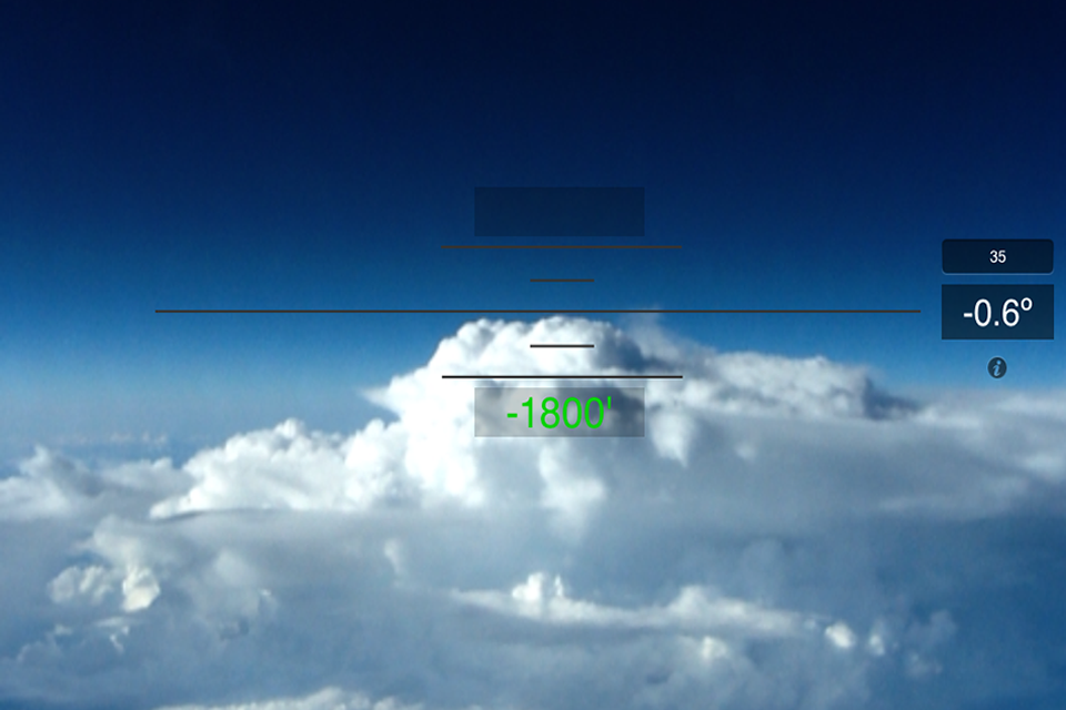
Pilots, it's time to get rid of your sight level, water bottle or whatever "old school" method you have been using to determine cloud height. Introducing Cloud Topper, a revolutionary new sight level designed specifically for the iPad and iPhone.
With Cloud Topper you can use your device camera, gyroscope and accelerometer as a traditional sight level. Plus you can enter the distance to a cloud and Cloud Topper will calculate your height above or below that cloud. The displayed cloud height is even corrected for the curvature of the earth.
Cloud topper is a fun, easy to use app that should be included in every pilots EFB.
Cloud Topper is not an FAA approved source to determine cloud height. Cloud Topper is not intended to replace weather radar or pilot skills and judgement. Always consult the Aircraft Manufacturer’s Aircraft Flight Manuals, Federal Aviation Administration (FAA) websites and publications, and individual company policies.
Ausblenden Mehr anzeigen...

Screenshots

Cloud Topper Häufige Fragen

  • Ist Cloud Topper kostenlos?

    Ja, Cloud Topper ist komplett kostenlos und enthält keine In-App-Käufe oder Abonnements.

  • Ist Cloud Topper seriös?

    🤔 Die Qualität der Cloud Topper-App ist gemischt. Einige Nutzer sind zufrieden, während andere Probleme melden. Ziehen Sie in Betracht, einzelne Bewertungen für mehr Kontext zu lesen.

    Danke für die Stimme

  • Wie viel kostet Cloud Topper?

    Cloud Topper ist kostenlos.

  • Wie hoch ist der Umsatz von Cloud Topper?

    Um geschätzte Einnahmen der Cloud Topper-App und weitere AppStore-Einblicke zu erhalten, können Sie sich bei der AppTail Mobile Analytics Platform anmelden.

Benutzerbewertung
Die App ist in Deutschland noch nicht bewertet.
Bewertungsverlauf

Cloud Topper Bewertungen

Basically a great idea...

Golino4783 on

Deutschland

because it's difficult to estimate if high enough to get over the clouds at altitude. Of course you can't use this app for measurement. But for any reason not even bearing really works. It's hard to find exactly 0 degrees but even then the app seem not to show straight level ahead. Maybe some improvement and more testing, then it could be a really helper.

Great, simple tool

Walkinghispath on

Vereinigte Staaten

I use this app weekly to determine tops of cells and required altitude to clear a buildup or cloud bank. It does require correlation between radar/stormscope info for best accuracy. NEXRAD works in a pinch.

Useless

J N C C on

Vereinigte Staaten

I haven’t found this useful at all. No clear instructions on how to calibrate or where to put the lines.

Wasted 99 cents.

Old Rancher Dude on

Vereinigte Staaten

This app is difficult to close. Locked up my I pad during flight. Had to reboot and bring ForeFlight back up. Not a good problem to try to solve while in flight. Had to hand my iPad to passenger to solve the problem. I should have practiced first and I would have know not to use this app while in flight.

Awful

TXPilot69 on

Vereinigte Staaten

I deleted it immediately, and wish I could get my money back. Two big problems: 1) once the app is opened and you grant camera access, you can’t swipe up and kill it or switch apps. I had to force reboot my phone to get back to the app switcher. 2) it requires you to know the distance to the cloud you’re measuring “using RADAR”. Like I have that?!

Not accurate

M20J flyer on

Vereinigte Staaten

Not very accurate. A small error in angle is a quite large when looking at a cloud which is miles away. This app consistently indicates I will fly into a cloud when in reality I clear it by seventy hundred feet.

Useful, Not Perfect

bdjohnson3 on

Vereinigte Staaten

Works well as a better refined guesstimator than the naked eye. It would be great if the artificial horizon had an option to always display at 0* and move on the screen relative to the phones actual angle... would be great for measuring in light chop.

Doesn't work

Mgustin2008 on

Vereinigte Staaten

Camera functions work, but you can't enter distance to get height. 99 cents down the drain. Worthless don't buy.

TCAS Tested

Random Dent on

Vereinigte Staaten

It works as advertised. I checked it against TCAS traffic and the altitude was spot on.

Useful

Scangadah on

Vereinigte Staaten

Great little tool. Lots of other uses too

Store-Rankings

Ranking-Verlauf
App-Ranking-Verlauf noch nicht verfügbar
Kategorien-Rankings
Diagramm
Kategorie
Rang
Top Bezahlt
134
Top Bezahlt
199
Top Bezahlt
317
Top Bezahlt
320
Top Bezahlt
379

Cloud Topper Konkurrenten

Name
FBOlink - Messaging
Bonanza Performance
C182 Performance
SwitcheOn
Just Works LTE Power Control
Coflyt
Intelligent Aircraft Ownership
SkewTLogPro
Lightspeed App
PA28 Performance
Flight Assessment of Risk Tool
Assess your risk before flight
PA28 W&B mobile
Piper PA28 Weight and Balance

Cloud Topper Installationen

Letzte 30 Tage

Cloud Topper Umsatz

Letzte 30 Tage

Cloud Topper Einnahmen und Downloads

Gewinnen Sie wertvolle Einblicke in die Leistung von Cloud Topper mit unserer Analytik.
Melden Sie sich jetzt an, um Zugriff auf Downloads, Einnahmen und mehr zu erhalten.
This page includes copyrighted content from third parties, shared solely for commentary and research in accordance with fair use under applicable copyright laws. All trademarks, including product, service, and company names or logos, remain the property of their respective owners. Their use here falls under nominative fair use as outlined by trademark laws and does not suggest any affiliation with or endorsement by the trademark holders.