DONIA

Navigate, Anchor and Protect

Veröffentlicht von: Andromede Oceanologie

Beschreibung

DONIA - Enjoy & protect the sea, together !
With its 50,000 users, DONIA protects the Mediterranean seabed (Posidonia meadows, coralligenous reefs, etc.) by providing a precise vision of the seabed for a serene and respectful anchorage. With Donia in your pocket you will be able to :
- Visualize precisely the seabed (sand, Posidonia, coralligenous, rock)
- Access all the useful information for your trip at sea: ports, regulations, diving sites
- Book your Donia Mooring buoys to enjoy safe and serene anchorages
- Share your observations with other users: anchorage spots, marine mammal sightings, obstacles at sea, etc.
- Prepare and follow your navigation with weather predictions, course and speed monitoring, measurement tools, etc.
- Monitor your mooring with skid, collision and entanglement alarms
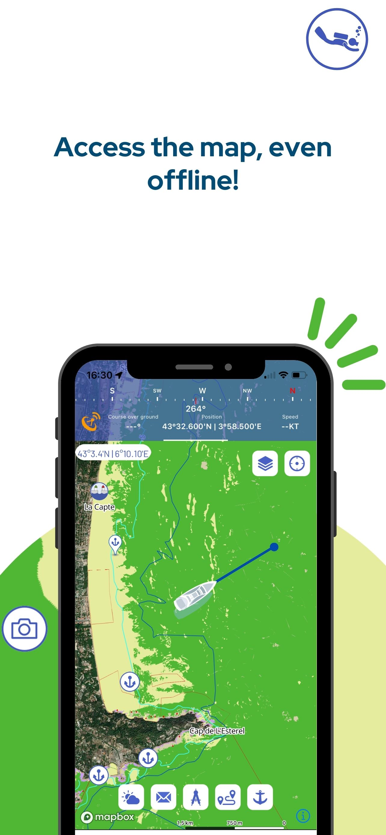
- Access to free mapping even offline
- Real-time access to marine activities through the AIS system, SOS alert and chat
- Access to SHOM charts and HD bathymetric data (Premium version only)!
And many more features!

*** Participate in the implementation of a more respectful yachting***
DONIA is above all a community of enthusiasts who exchange information to make their sailing or motoring trips easier, richer, safer and more respectful. Since 2018, Donia users have helped preserve 76 ha of posidonia from being uprooted by anchoring, why not you?

*** By enthusiasts for enthusiasts***
Created by marine biologists and divers from Andromède Océanologie, Donia aims to make maps of the seabed visible and accessible so that everyone can participate in their protection. In order to take advantage of the famous maritime solidarity, the application responds to the desires of users and listens to them in order to make it an innovative and effective tool for anchoring and protection.

*** DONIA Mooring ***
The DONIA application incorporates the mapping of buoys and mooring boxes into a buoy reservation module called "DONIA Mooring". It integrates, in real time: the availability calendar of these mooring devices, pricing by class of vessel and slots, reservation and management of secure payment via mobile phone.

*** DONIA PREMIUM ***
The Premium version of the application (€24.99 per year, €2.99 per month) gives access to the SHOM (Service Hydrographique et Océanographique de la Marine) charts (updated in 2022) as well as nearly 230 high-definition bathymetric charts allowing any user to find new sites of interest, plan diving routes, or even visualise faults and rocky outcrops

Want to help us improve DONIA? Find us on Facebook, Instagram and LinkedIn to share your best finds!

Facebook: https://www.facebook.com/Donia.andromede
Instagram: https://www.instagram.com/donia_andromede/
LinkedIn: https://www.linkedin.com/showcase/42123722/

Please note that continuous use of the GPS in the background may reduce battery life.
Terms of use: https://donia.fr/cgu/cgv_fr.html
The DONIA community application for navigation and anchoring outside fragile ecosystems is available and used in the Mediterranean. It is available in English, French, Spanish and Italian on smartphones and tablets.
Ausblenden Mehr anzeigen...

In-App-Käufe

DONIA® Premium Monthly
฿79.00
DONIA® Premium Version
฿699.00

Screenshots

DONIA Häufige Fragen

  • Ist DONIA kostenlos?

    Ja, DONIA ist kostenlos herunterzuladen, enthält jedoch In-App-Käufe oder Abonnements.

  • Ist DONIA seriös?

    🤔 Die DONIA-App scheint anständig zu sein. Es gibt Raum für Verbesserungen, aber im Allgemeinen sind die Nutzer zufrieden.

    Danke für die Stimme

  • Wie viel kostet DONIA?

    DONIA bietet mehrere In-App-Käufe/Abonnements, der durchschnittliche In-App-Preis beträgt 389.00 ฿.

  • Wie hoch ist der Umsatz von DONIA?

    Um geschätzte Einnahmen der DONIA-App und weitere AppStore-Einblicke zu erhalten, können Sie sich bei der AppTail Mobile Analytics Platform anmelden.

Benutzerbewertung
Die App ist in Thailand noch nicht bewertet.
Bewertungsverlauf

DONIA Bewertungen

super appli, mais petits soucis qui gâchent

PatMBS on

Frankreich

Appli impressionnante pour la localisation de la nature des fonds. J’ai même pris la version premium, qui inclut les cartes SHOM. MAIS MAIS une fois l’affichage SHOM demandé, impossible de revenir à l’affichage nature des fonds. Il faut sortir de l’appli et ensuite la relancer. Perte de temps. La fonction ancrage et alarme dérapage ne s’active pas. Donc 2 étoiles en moins… Relevé AIS inconstant. Visible seulement si localisation désactivée( sur IOS). Et encore, il n’y a rien dans la région Toulon (!), mais Ok vers Marseille ou St-Tropez… et dans plein d’ailleurs dans le monde… Seule question : Quelle utilité pour un Premium, certes peu coûteux, mais inexploitable ou versatile? Mais pour le choix du lieu de mouillage, c’est top. C’est même le top la nuit (ce serait toptop si, couplé à SHOM, on avait les profondeurs et récifs).

super appli, mais petits soucis qui gâchent

PatMBS on

Frankreich

Appli impressionnante pour la localisation de la nature des fonds. J’ai même pris la version premium, qui inclue les cartes SHOM. MAIS MAIS une fois l’affichage SHOM demandé, impossible de revenir à l’affichage nature des fonds. Il faut sortir de l’appli et ensuite la relancer. Perte de temps. La fonction ancrage ne s’active pas. Donc 2 étoiles en moins…

Facile intuitive

Poufitchou on

Frankreich

Application facile d’emploi Très intuitive Précision de la cartographie

Très bonne appli

Fougne on

Frankreich

Bonne précision , facile pour repérer les bancs de sable , un pti geste en plus pour protéger la Posidonie a s’en servir sans modérations.

Indispensable !

Joguo06 on

Frankreich

Précis, fiable, pratique, validé. 😎

Application très utile

capitainejv on

Frankreich

Je l’utilise régulièrement pour les mouillages ça permet de préserver la posidonie et d’éviter les rochers pour éviter de coincer l’ancre Merci à vous

Super utile

Grandfred34 on

Frankreich

Bravo à l équipe de développeurs C’est une appli au top

L’appli indispensable pour ne pas détruire les fonds marins

zinbaa on

Frankreich

Le permis bateau ne nous apprend pas à poser une ancre, ni à la remonter correctement. Alors, au moins ancrons-nous sur du sable, c’est ce que Donia permet de faire (entre autres) !

Super

Tom0000005 on

Frankreich

Super application avec toutes les fonctionnalités qu’il faut pour trouver le bon endroit pour mouiller

Avis

TERRA E MARE on

Frankreich

Je recommande cette application. Je m’adresse aux développeurs, une ligne indiquant la zone des 300m tout le long des côtes, visible sur vos cartes, serait d’une grande utilité et intéresserait de nombreux plaisanciers. Merci pour votre application bien utile.

Store-Rankings

Ranking-Verlauf
App-Ranking-Verlauf noch nicht verfügbar
Kategorien-Rankings
Diagramm
Kategorie
Rang
Top Umsatz
52
Top Umsatz
60
Top Umsatz
64
Top Umsatz
69
Top Kostenlos
273

DONIA Konkurrenten

Name
SailFreeGPS
Sailing navigation intruments
Navily
Your mobile cruising guide
TZ iBoat – Marine Navigation
Boat GPS, Charts, AIS, Tides
B&G: Companion App for Sailors
Great sailing charts
Anchor Watch Alarm: ZENKOU PRO
Boat Monitor Onboard & Ashore
Anchor! drag alarm
simple drag alarm for sailors
Imray Navigator
PosidoniaMaps
Posidonia High Resolution Maps
qtVlm
Navigation and weather routing
Nav&Co
Naviguez bien informé

DONIA Installationen

Letzte 30 Tage

DONIA Umsatz

Letzte 30 Tage

DONIA Einnahmen und Downloads

Gewinnen Sie wertvolle Einblicke in die Leistung von DONIA mit unserer Analytik.
Melden Sie sich jetzt an, um Zugriff auf Downloads, Einnahmen und mehr zu erhalten.