Can’t without DroneDeploy!
The best thing to happen to UAVs since UAVs!

Ja, DroneDeploy Flight App ist komplett kostenlos und enthält keine In-App-Käufe oder Abonnements.
🤔 Die Qualität der DroneDeploy Flight App-App ist gemischt. Einige Nutzer sind zufrieden, während andere Probleme melden. Ziehen Sie in Betracht, einzelne Bewertungen für mehr Kontext zu lesen.
DroneDeploy Flight App ist kostenlos.
Um geschätzte Einnahmen der DroneDeploy Flight App-App und weitere AppStore-Einblicke zu erhalten, können Sie sich bei der AppTail Mobile Analytics Platform anmelden.

4.5 von 5
2 Bewertungen in Saudi-Arabien
The best thing to happen to UAVs since UAVs!
I know mission planner really well. It’s what I work off but this is fun and easy. You can get a mission up and going to five minutes.
I’ve been using a Mavic 2 and GSPro for a while, but with the recent firmware update with Remote ID, it was no longer supported, so I had to use DroneDeploy. This app fails on numerous fronts…It FAILS to resume a mission if more than one battery is required. When I try to exit automatic landing, it still persists, even if I close the application and disconnect my iPad - PILOTS BE WARNED OF IMPRECISE AND AGGRESSIVE LANDINGS!! Be ready to manually catch a fast descending drone. I attempted to set the camera settings in DJI GO4, but drone deploy overrode the parameters anyway and used a shutter speed WAY too low for mapping that resulted in my imagery having motion blur. It also fails to capture the required images at the preprogrammed overlap, which makes basic mapping unbelievably challenging. I used an iPad Gen6 running the latest iOS, but the app is extremely slow if I’m lucky enough for it not to crash at all. I’m not sure how anybody is having any success with this application. Unfortunately Pix4D capture just doesn’t have a lot of settings to control…
Used this app on my smart phone and my Samsung tablet with no issue. Now installed on my iPad and it only goes blue screen and close it self.
No matter what I do, my Air 2S keeps freezing during a mission - saying “Calibrating Camera Focus”. I’ve been in contact with DJI support for over a week going through all kinds of tests and even calibrated with DJI Assist to no avail. They his app is now useless to our needs. Really disappointing.
Software stopped showing the path of the drone with the little blue triangular figure. That was a bit scary.
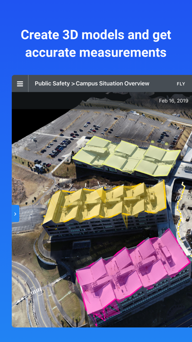
The best flight planning, mapping and analysis software I’ve used. Very easy to program flights and export data to AutoCAD. Easily create profiles, Point clouds and it even can auto tag GCPs. Have not regretted the move from previous software.
I have been a user for 5 years and every so often, I have to fully delete the app and reinstall to alleviate the overheating. Today I reinstalled 3 times but just keeps getting hot. Have to fly with iPad on an ice pack
Excellent program. Easy to understand and operate.
Camera view frequently does not work. Randomly freezes or glitches. Missions will glitch halfway through creating mismatched maps.
|
Diagramm
|
Kategorie
|
Rang
|
|---|---|---|
|
Top Kostenlos
|

|
100
|
|
Top Kostenlos
|

|
286
|
|
Top Kostenlos
|

|
394
|
|
Top Kostenlos
|

|
405
|
|
Top Kostenlos
|

|
452
|
| Name | Downloads (30d) | Monatlicher Umsatz | Rezensionen | Bewertungen | Letzte Veröffentlichung | |
|---|---|---|---|---|---|---|

DJI GO 4
Spark, P4 Series, Mavic and I2
|
Freischalten
|
Freischalten
|
20
|
|
vor 1 Monat | |

Sync for DJI: Go Mobile First
H265, 4K, RAW, hyperlapse, etc
|
Freischalten
|
Freischalten
|
0
|
|
vor 1 Monat | |
Go Fly for DJI Drones
Mavic, Air, Mini, Phantom, FPV
|
Freischalten
|
Freischalten
|
1
|
|
vor 6 Monaten | |

DJI Fly
Fly as you are.
|
Freischalten
|
Freischalten
|
58
|
2
|
vor 1 Monat | |

Litchi for DJI Drones
Unlock your drone's potential
|
Freischalten
|
Freischalten
|
6
|
|
vor 4 Monaten | |

Map Pilot Pro
Collect the best data possible
|
Freischalten
|
Freischalten
|
0
|
|
vor 1 Woche | |

DroneVR - FPV for DJI drones
VR,FPV,DJI,Phantom,Mavic,Drone
|
Freischalten
|
Freischalten
|
0
|
|
vor 1 Jahr | |

Autel Explorer
|
Freischalten
|
Freischalten
|
1
|
|
vor 1 Jahr | |

Skydio
Breakthrough intelligence.
|
Freischalten
|
Freischalten
|
0
|
|
vor 1 Jahr | |

PIX4Dcapture Pro: drone flight
Fly with Parrot and DJI drones
|
Freischalten
|
Freischalten
|
0
|
|
vor 2 Monaten |
