
Elevation For Real
Beschreibung
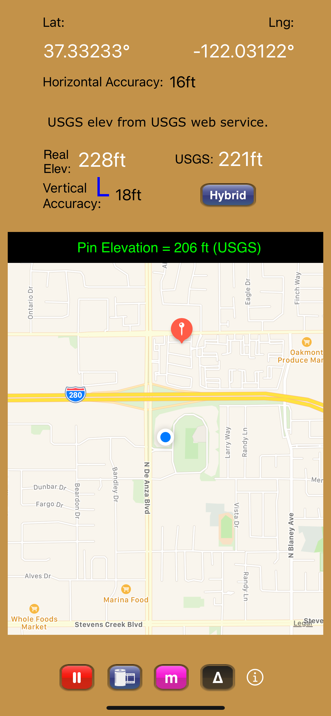
As a bonus, we've also included access to the USGS Elevation Web Service which provides US ground elevation data. You'll be amazed at how, when you have a good view of the sky, Elevation For Real's internally generated elevation converges on the USGS value after just a short time. Outside the U.S., or on iOS devices with non-U.S. region settings, or if the USGS elevation service is unavailable, Shuttle Radar Topography Mission (SRTM) published elevation data is shown between 60°N and 56°S latitude.
Here are some more features:
- Real-time map which displays your location
- Estimated vertical and horizontal accuracy
- Spot elevation data displayed by tapping map
- English or metric units based on your region setting
- Start/Stop button
- One touch screenshots
- NO Third-Party Ads!
- Optional pressure altimeter (in-app purchase). Measure relative altitudes or calibrate to an elevation benchmark. Use indoors or out. Even works in Airplane Mode! Note: your iOS device must be equipped with a barometer to access pressure altimeter functionality. The iPhone 6 and later and the iPad Air 2 and later have barometers.
Download Elevation For Real today!
Notes:
1) homedatasheet.com, Inc. is not affiliated with USGS. USGS Elevation Web Service is available to the general public online, at no cost.
2) SRTM is provided by geonames.org. homedatasheet.com, Inc. is not affiliated with geonames.org. U.S.-based users should note that, in many instances, the SRTM data is not as accurate as USGS data. All users should note that, in certain locations, the SRTM dataset may be tens of meters or more in error.
3) ***The initial view of this app requires a GPS signal to work properly. A clear view of the sky is needed for GPS reception, and it may take several seconds to get a position fix. Elevation for Real will run on devices not equipped with a GPS receiver and GPS-equipped devices that are not receiving a GPS signal, but any resulting elevation readings will just be the approximate ground elevation at your location, even if you are several stories up in a tall building.
4) ***Any elevation measurements with personal safety or financial implications should be performed by professionals with professional GPS equipment. Elevation for Real is not intended to determine flood hazard. Consult a licensed professional in your jurisdiction, such as a surveyor or engineer, when dealing with flood risk.
In-App-Käufe
- Pressure Altimeter
- $990
Screenshots

Elevation For Real Häufige Fragen
-
Ist Elevation For Real kostenlos?
Ja, Elevation For Real ist kostenlos herunterzuladen, enthält jedoch In-App-Käufe oder Abonnements.
-
Ist Elevation For Real seriös?
Nicht genügend Bewertungen, um eine zuverlässige Einschätzung vorzunehmen. Die App benötigt mehr Nutzerfeedback.
Danke für die Stimme -
Wie viel kostet Elevation For Real?
Elevation For Real bietet mehrere In-App-Käufe/Abonnements, der durchschnittliche In-App-Preis beträgt 990.00 $.
-
Wie hoch ist der Umsatz von Elevation For Real?
Um geschätzte Einnahmen der Elevation For Real-App und weitere AppStore-Einblicke zu erhalten, können Sie sich bei der AppTail Mobile Analytics Platform anmelden.

1.5 von 5
2 Bewertungen in Chile
Elevation For Real Bewertungen
Store-Rankings
Schlüsselwörter
Elevation For Real Konkurrenten


Elevation For Real Installationen
Letzte 30 Tage
Elevation For Real Umsatz
Letzte 30 TageElevation For Real Einnahmen und Downloads
Melden Sie sich jetzt an, um Zugriff auf Downloads, Einnahmen und mehr zu erhalten.
App-Informationen
- Kategorie
- Navigation
- Herausgeber
- homedatasheet.com
- Sprachen
- English
- Letzte Veröffentlichung
- 11.0 (vor 1 Monat )
- Veröffentlicht am
- Dec 29, 2009 (vor 14 Jahren )
- Auch verfügbar in
- Vereinigtes Königreich, Vereinigte Staaten, Australien, Chile, Argentinien, Thailand, Saudi-Arabien, Philippinen, Niederlande, Japan, Italien, Israel, Irland, Sonderverwaltungsregion Hongkong, Frankreich, Spanien, Deutschland, Österreich, Kanada, Schweiz, Aserbaidschan, Nigeria, Brasilien, Peru, Belgien, Pakistan, Polen, Portugal, Rumänien, Mexiko, Schweden, Singapur, Türkei, Taiwan, Ukraine, Vereinigte Arabische Emirate, Vietnam, Südafrika, Kolumbien, Ecuador, Ägypten, Dominikanische Republik, Dänemark, Griechenland, Tschechien, Ungarn, Indonesien, Malaysia, China, Indien, Südkorea, Kuwait, Kasachstan, Libanon, Algerien, Finnland, Neuseeland
- Zuletzt aktualisiert
- vor 1 Woche
- © 2024 AppTail.
- Unterstützung
- Privacy
- Terms
- All Apps