I love it but..
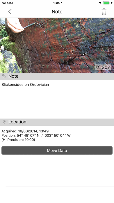
Unfortunately if i look at a picture in my Notes i am not able to return from picture view without closing the app completely! Is there e gesture i have not tried yet? Otherwise easy to use and very helpfull in the field!


Ja, FieldMove Clino ist komplett kostenlos und enthält keine In-App-Käufe oder Abonnements.
🤔 Die Qualität der FieldMove Clino-App ist gemischt. Einige Nutzer sind zufrieden, während andere Probleme melden. Ziehen Sie in Betracht, einzelne Bewertungen für mehr Kontext zu lesen.
FieldMove Clino ist kostenlos.
Um geschätzte Einnahmen der FieldMove Clino-App und weitere AppStore-Einblicke zu erhalten, können Sie sich bei der AppTail Mobile Analytics Platform anmelden.

4.5 von 5
2 Bewertungen in Österreich
Unfortunately if i look at a picture in my Notes i am not able to return from picture view without closing the app completely! Is there e gesture i have not tried yet? Otherwise easy to use and very helpfull in the field!
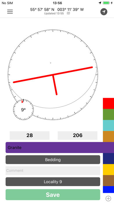
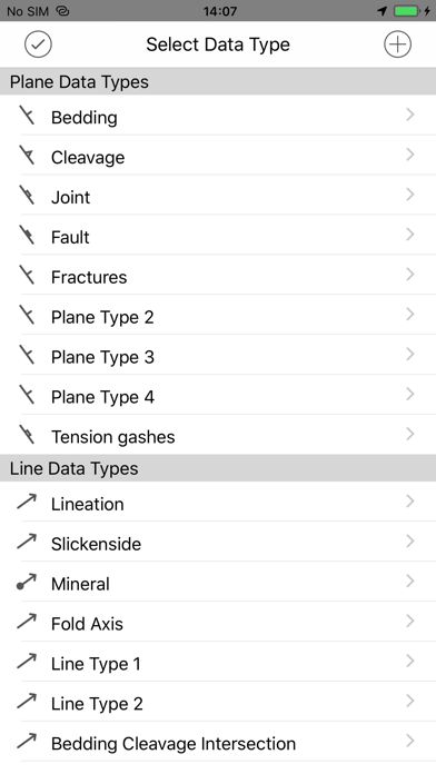
It does not work with dark mode which hurts in the field because you drain your phone battery faster when using light mode, and it occasionally has a bad reading and gets stuck that way when doing S/D measurements. This can result in a wacky misunderstanding of the structural features in an area so it is best to keep a brunton compass on you and double check periodically. Otherwise, it’s a solid app!
best geo app by far. will give 5 stars will they fix the dark mode issue
Please fix the live strike/dip dark mode problem of showing the data as white text on a white background. Also can you make sure the app fills the screen on a iPhone X and iPhone 11 plus? It makes you look a little amateurish when the app doesn’t fill the whole screen and there’s black bars on the top and bottom.
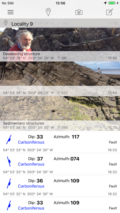
I have used this tool for two years now doing geologic mapping for my master’s thesis and it has been an invaluable tool. The only issue I have is that the image function in the notes section causes the app to crash every time. It would be fantastic to see this fixed, as that would enable me to use this app as my primary tool. Additionally, if there could be a tracking section added to the maps portion, it would be quite easy to map large swaths of rock simply by walking the contacts!
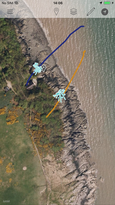
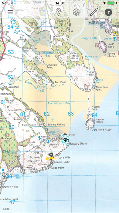
There are so many things I love about this app. It’s now my primary mapping tool for everything: strikes and dips, faults, slickensides, notes, geotagged images, annotating the map. Last field season it worked a little smoother, so I’m wondering if there’s some bugs with new iPhone update... Some actions that cause Clino to crash: - trying to take a picture from within the app using the “camera” icon. - I can make a note and upload “existing picture” (it’s an extra step) but “new picture” crashes again. - clicking on a line in map view It would be great to upload a better base map. I’ve been switching between Gaia and Google Earth to see if the location is correct. It’s sometimes 10-20 feet off, which is an issue. Even if the imagery isn’t great, it’s be nice to be able to zoom in closer for fat-fingered drawing. Other than that, this app is great. I’m grateful that the S/D symbols show up in google earth along with meta data and stratigraphic units. Makes my data management so much easier.
It's a great program that deserves more stars, but since the latest upgrade it keeps crashing every time I attempt to export the data. Meaning that all the work I did with this app is essentially lost! Please fix this so I can use this app and write a review that reflexes its merits.
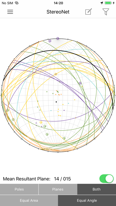
Downloaded this before my geology capstone - revolutionized my field notes. It's so nice to have pictures and measurements all placed on the map. And very convenient to have a real time stereo net! Way worth the upgrade!
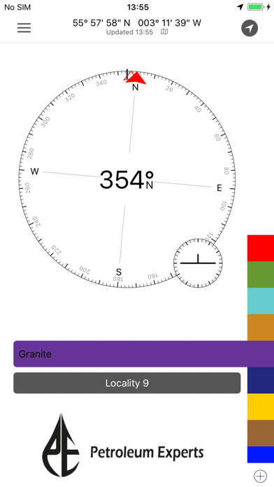
We recently used the pro version of this app to measure more than 3,500 orientations in less than two weeks, all tagged with latitude, longitude, time, and date. It was indispensable for our purposes. We periodically checked it against our Brunton compasses and found that it was virtually always within 5° and commonly within 2° with calibration as needed (this on an iPhone 5S). Bruntons are undoubtedly more accurate for single observations but this is balanced out by the fact that you can make so many more observations with FieldMove Clino and average them, providing a better handle on uncertainties. The interface of the app works well with our workflow and the ability to back up your data, either by emailing yourself a copy or uploading to DropBox whenever you have cellular data or wireless connection to the Internet, brought considerable peace of mind. The data, when output as .csv files can be read by modern desktop stereonet programs and the .kmz output will plot your oriented strike and dips symbols right in Google Earth. If you're going to use this as much as we did, I'd recommend investing in a 15000mAh Li external battery (about $50 online) as our phones would not quite make it through the entire day (making ~300 measurements/day). A battery that size is about the size and shape of a small paperback and will recharge the phone 4-5 times and so is essential if you are camping.
There appears to be an error with the calibration of the compass. My strikes are consistently 10 to 15 degrees off from a brunton measurement. I have tried numerous calibrations of both the app and the compass on the iphone. I'm using an iPhone 5s and I know there are some hardware issues, but the compass is ~10 degrees off from the midland valley fieldmove clino compass when held in the same orientation.
|
Diagramm
|
Kategorie
|
Rang
|
|---|---|---|
|
Top Kostenlos
|

|
400
|
| Name | Downloads (30d) | Monatlicher Umsatz | Rezensionen | Bewertungen | Letzte Veröffentlichung | |
|---|---|---|---|---|---|---|
Mein GPS-Koordinaten
My GPS Coordinates
|
Freischalten
|
Freischalten
|
0
|
|
vor 2 Jahren | |

ArcGIS Field Maps
|
Freischalten
|
Freischalten
|
0
|
|
vor 2 Monaten | |

QField for QGIS
Efficient field work for QGIS
|
Freischalten
|
Freischalten
|
0
|
|
vor 2 Wochen | |

SW Maps
GIS and Data Collector
|
Freischalten
|
Freischalten
|
0
|
|
vor 2 Monaten | |

ArcGIS Earth
|
Freischalten
|
Freischalten
|
0
|
|
vor 1 Woche | |

ArcGIS Companion
|
Freischalten
|
Freischalten
|
0
|
|
vor 3 Jahren | |
İnklinometre iletki
45 Grad = Steigung 100%
|
Freischalten
|
Freischalten
|
0
|
|
vor 7 Monaten | |

Chptr
|
Freischalten
|
Freischalten
|
0
|
|
vor 1 Woche | |

GEO5 Data Collector
|
Freischalten
|
Freischalten
|
0
|
|
vor 11 Monaten | |

Geologie-Klinometer
Messen und Notizen machen
|
Freischalten
|
Freischalten
|
0
|
|
vor 2 Monaten |
