Hiking log & outdoor maps

Collect hiking badges

Veröffentlicht von: SummitLynx

Beschreibung

You can record your summit successes directly on your smartphone! With the SummitLynx app you can record your mountain tours, bike tours, climbing tours and skiing tours just like in a summit or tour book. The digital hiking maps in the app facilitate orientation in the mountains.
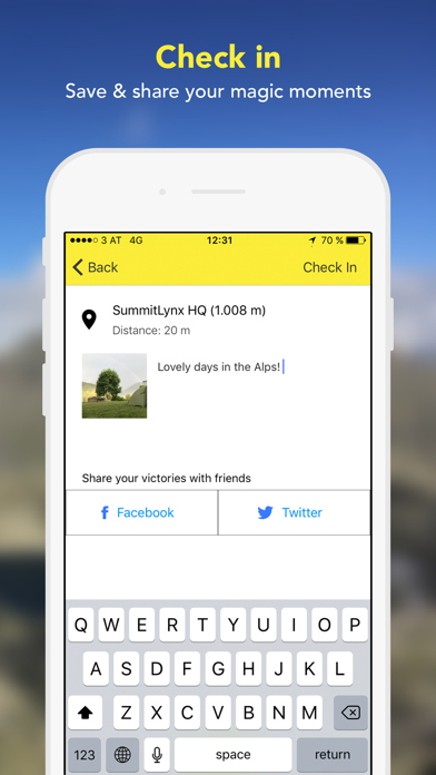
High up on the mountain or along gentle landscapes - record your sportive activities in the app at 400 000 worldwide destinations altogether. If you want, you can share these successes with your friends - directly via the app or via Facebook and Twitter. At the same time, you collect points for hiking badges and take part in competitions and campaigns. Thus, you will be even more motivated to explore nature and reach your goals.
Especially useful: The emergency function mySOS. Enter a contact person who will receive a text message in case you are not back from your hike at the agreed time. Thanks to GPS tracking the mountain rescue service can find you more easily. Ideal for those, who want to increase their safety in the mountains or who are often out and about on their own.

Functions:
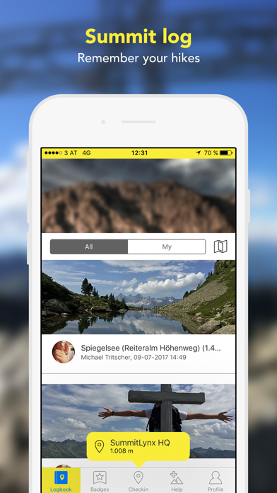
* The smartphone will be your personal summit or tour book
* The digital summit book entries comprise the name of the destination, date & time (by means of automatic GPS localisation). Manually add a picture and a personal note in order to complete your memories just like in a hiking book.
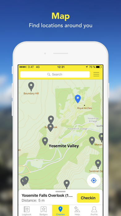
* There are over 400 000 worldwide alpine destinations in the hiking app - summits, mountain cabins, via ferrata, lakes, glaciers, mountain passes and other points of interest. Your smartphone becomes your tour book and your digital stamp pass.
* You can enter different types of movement in your digital tour book: Hikes, bike tours, climbing tours, skiing tours, winter hikes and cross-country skiing tours.
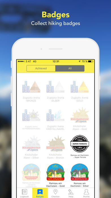
* Collect hiking badges with the digital hiking pass and take part in competitions.
* Emergency communication with mySOS, should something happen to you during the tour.
* Friends list: Share your mountain experiences with your friends.
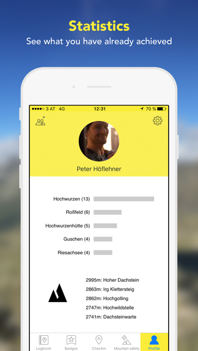
* Get informative statistics about your hiking tours and other mountain experiences.
* Entries are possible without internet connection! Your entries will be temporarily stored until you will be online again.

Functions in our partner regions:
* Approximately 40 partner regions, where you can collect hiking badges and redeem them in the tourist office.
* Tour planning: The most important and popular tours are registered in the app, including length, short description and elevation profile.

In these regions you can collect hiking badges:
* Achensee / Tyrol
* Adlerweg in Tyrol
* Allgäu / Bavaria
* Alpenregion Tegernsee Schliersee / Bavaria
* Bad Kleinkirchheim / Carinthia
* Bad Radkersburg / Styria
* Böhmerwald / Upper Austria
* Ferienregion Imst / Tyrol
* Ferienregion Nationalpark Bayrischer Wald / Bavaria
* Ferienregion Renchtal / Baden-Württemberg
* Gröden / Southern Tyrol
* Hochkönig / Salzburg
* Hochsteiermark / Styria
* Hall-Wattens / Tyrol
* Kaiserwinkl / Tyrol
* Kitzbühel / Tyrol
* Kufsteinerland / Tyrol
* Lamer Winkl / Bavaria
* Lech am Arlberg / Vorarlberg
* Maishofen / Salzburg
* Murau-Murtal / Styria
* Naturpark Almenland / Styria
* Nesselwang / Bavaria
* Olympiaregion Seefeld / Tirol
* Obergraz / Styria
* Obertauern / Salzburg
* Ötztal / Tyrol
* Saalbach-Hinterglemm / Salzburg
* Salzkammergut / Upper Austria, Salzburg & Styria
* Schladming-Dachstein / Styria
* St. Johann in Tirol / Tyrol
* Stubai / Tyrol
* Südsteirische Weinstraße / Styria
* Tiroler Zugspitz Arena / Tyrol
* Top Trails of Germany
* Westerwald / NRW, Hessen, Rhineland-Palatinate
* Wilder Kaiser / Tyrol
* Wildschönau / Tyrol
* Zell am See - Kaprun / Salzburg
* Ötztal / Tyrol

Please find a current list on https://www.summitlynx.com/en/region/
Should you have any questions or suggestions, please contact us at [email protected].
Ausblenden Mehr anzeigen...

Screenshots

Hiking log & outdoor maps Häufige Fragen

  • Ist Hiking log & outdoor maps kostenlos?

    Ja, Hiking log & outdoor maps ist komplett kostenlos und enthält keine In-App-Käufe oder Abonnements.

  • Ist Hiking log & outdoor maps seriös?

    🤔 Die Qualität der Hiking log & outdoor maps-App ist gemischt. Einige Nutzer sind zufrieden, während andere Probleme melden. Ziehen Sie in Betracht, einzelne Bewertungen für mehr Kontext zu lesen.

    Danke für die Stimme

  • Wie viel kostet Hiking log & outdoor maps?

    Hiking log & outdoor maps ist kostenlos.

  • Wie hoch ist der Umsatz von Hiking log & outdoor maps?

    Um geschätzte Einnahmen der Hiking log & outdoor maps-App und weitere AppStore-Einblicke zu erhalten, können Sie sich bei der AppTail Mobile Analytics Platform anmelden.

Benutzerbewertung
Die App ist in Tschechien noch nicht bewertet.
Bewertungsverlauf

Hiking log & outdoor maps Bewertungen

Super App und mega Support!!!

ElofinW on

Deutschland

Tolle benutzerfreundliche App, bei der man sich schon vorab auf das Ziel freut! Zudem kann man sich diverse Abzeichen (Wandernadeln) und andere Belohnungen erwandern und hat immer eine schöne Übersicht der erreichten Ziele! Für mich top! Nicht zu übertreffen ist aber der extrem schnelle und unkomplizierte Support, den hier auch schon andere User in den höchsten Tönen gelobt haben-zu Recht! Macht unbedingt weiter so!!!

Tourenbuch lässt sich nicht verändern

--Anonym— on

Deutschland

Nach mehrmaliger Eingabe eines erklungenen Gipfels wurde dieser mehrfach im Tourenbuch verzeichnet, jedoch lässt es sich nicht bearbeiten und damit ist es unnötig oft hinterlegt. Das Konzept dieser App ist irgendwie nicht zuende gedacht. Vielleicht wird sie in Zukunft besser, bis dahin lösche ich sie vorerst, da nichts mit anzufangen ist.

Fehlende Filtermöglichkeiten

Kirbika5 on

Deutschland

Schön gemacht, aber leider kann man in der Kartenansicht nicht ausschließlich nach Nadeln filtern.

Sehr hölzern

Maik kurz on

Deutschland

Nicht immer schlüssig und sehr hölzern in der Bedienung Alle meine Nadeln sind auf einmal weg

🤔

Hang Wengzweng on

Deutschland

Gibt’s euch noch?

Absolute Begeisterung und Motivation

SimoneMariaP on

Deutschland

Die App ist einfach fantastisch und motiviert, sämtliche Gipfel bzw Orte zu entdecken! Man will schließlich nicht nur Bronze oder Silber, sondern am besten auch gleich noch die Goldnadel holen ;) Ich hatte aufgrund der Anmeldung per Apple ID (nicht empfehlenswert, sich so anzumelden!!) einige Probleme, die aber sehr schnell vom Support gelöst wurden - absolut toller Support!

Tolle App

Vest 2023 on

Deutschland

Immer wenn wir in Wanderurlaub sind kram ich diese App wieder vor. Es macht unheimlich Spaß den nächsten Check Inn zu finden und treffen.

Super App!!!

Hatti1963 on

Deutschland

Die App ist ja schon super. Der Support ist nicht mehr zu verbessern. Ich habe sogar ein telefonischen Rückruf innerhalb von 5 Minuten bekommen. Besser geht es nicht!! Eigentlich müsste ich 10 Sterne geben.

Tolle App und großartiger Support

Steinbock on Tour on

Deutschland

Als Fernwanderin und Bergsteigerin nutze ich die App gerne und viel. Das Tourenbuch mit Fotos ist eine schöne Erinnerung an wunderschöne Touren, Landschafts- und Gipfelmomente. Bei einer kleinen Fehlfunktion auf Tour bekam ich innerhalb eines Tages Hilfe vom Support. Das ist wirklich Service vom Feinsten. 100%ige Empfehlung für die App.

Zufriedenheit

Danielschlue154 on

Deutschland

Seit Jahren verwende ich die App und sie ist immer zuverlässig.!

Store-Rankings

Ranking-Verlauf
App-Ranking-Verlauf noch nicht verfügbar
Kategorien-Rankings
App ist noch nicht gerankt

Schlüsselwörter

Hiking log & outdoor maps Konkurrenten

Name
Outdoor Navigation ape@map
Hiking, Biking & Ski tours
Harz
bergfex: hiking & tracking
Tour planner & GPS navigation
alpenvereinaktiv
Tourenportal der Alpenvereine
KOMPASS Outdoor & Hiking Maps
Schladming-Dachstein
Travel-Guide and Guest-Card
Locandy
Rother: Hiking & Maps
The best hikes.
RealityMaps 3D tour planner
Ski, Hike, Bike, Mountaineer
Summit, Hiking Log Peakhunter
Logbook with Topo Maps

Gipfelbuch & Wandertouren Installationen

Letzte 30 Tage

Gipfelbuch & Wandertouren Umsatz

Letzte 30 Tage

Hiking log & outdoor maps Einnahmen und Downloads

Gewinnen Sie wertvolle Einblicke in die Leistung von Gipfelbuch & Wandertouren mit unserer Analytik.
Melden Sie sich jetzt an, um Zugriff auf Downloads, Einnahmen und mehr zu erhalten.

App-Informationen

Kategorie
Travel
Herausgeber
SummitLynx
Sprachen
Czech, Dutch, English, French, German, Hungarian, Italian, Japanese, Polish, Portuguese, Russian, Slovak, Slovene, Spanish
Letzte Veröffentlichung
4.1 (vor 2 Jahren )
Veröffentlicht am
Aug 7, 2012 (vor 12 Jahren )
Zuletzt aktualisiert
vor 1 Tag