Downloads
Umsatz
Beschreibung
-This app gives you any full street address and post code on the map.
-Taking photo, checking in and stamping existing old memory photos with place and date.
-Long press on any location on map to get the full street address, location, temperature and pm2.5 pollution.
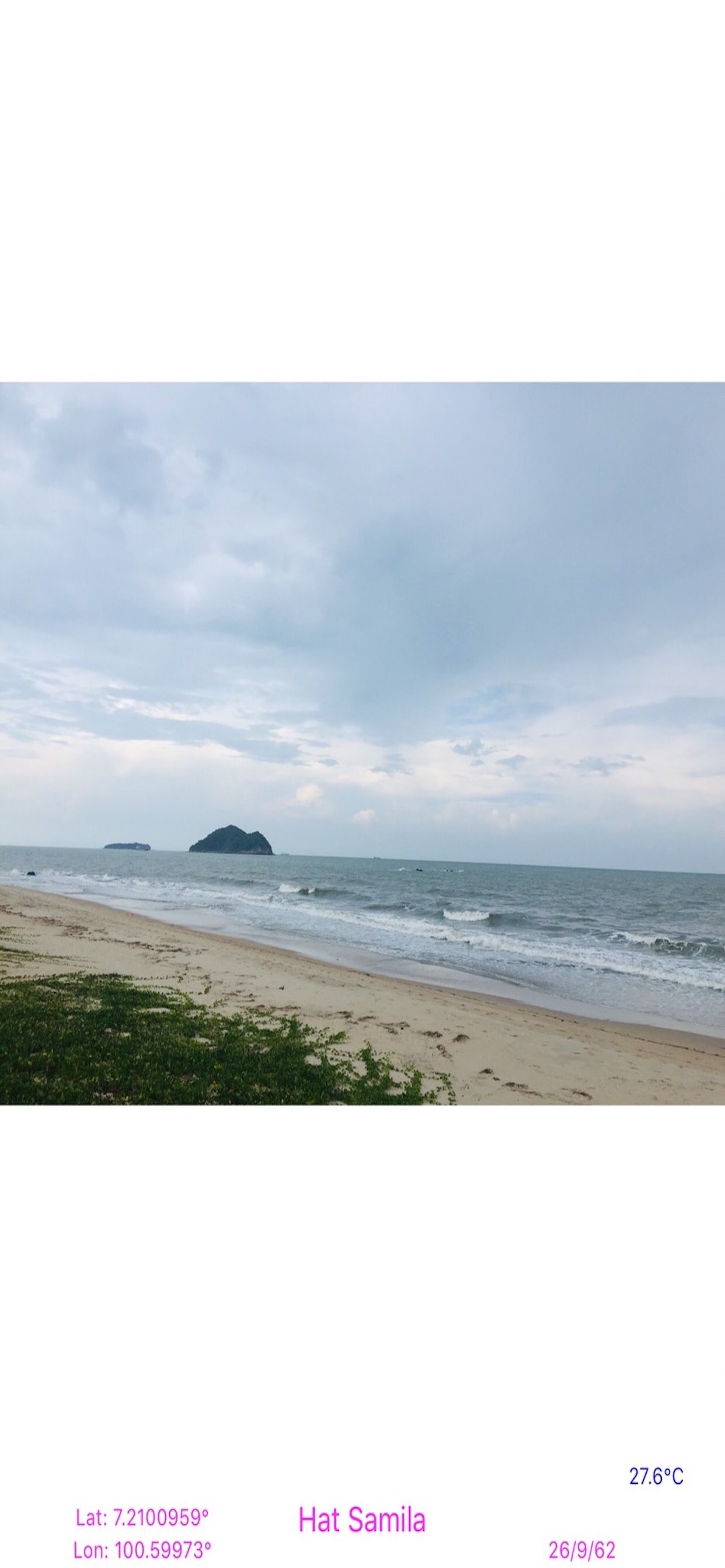
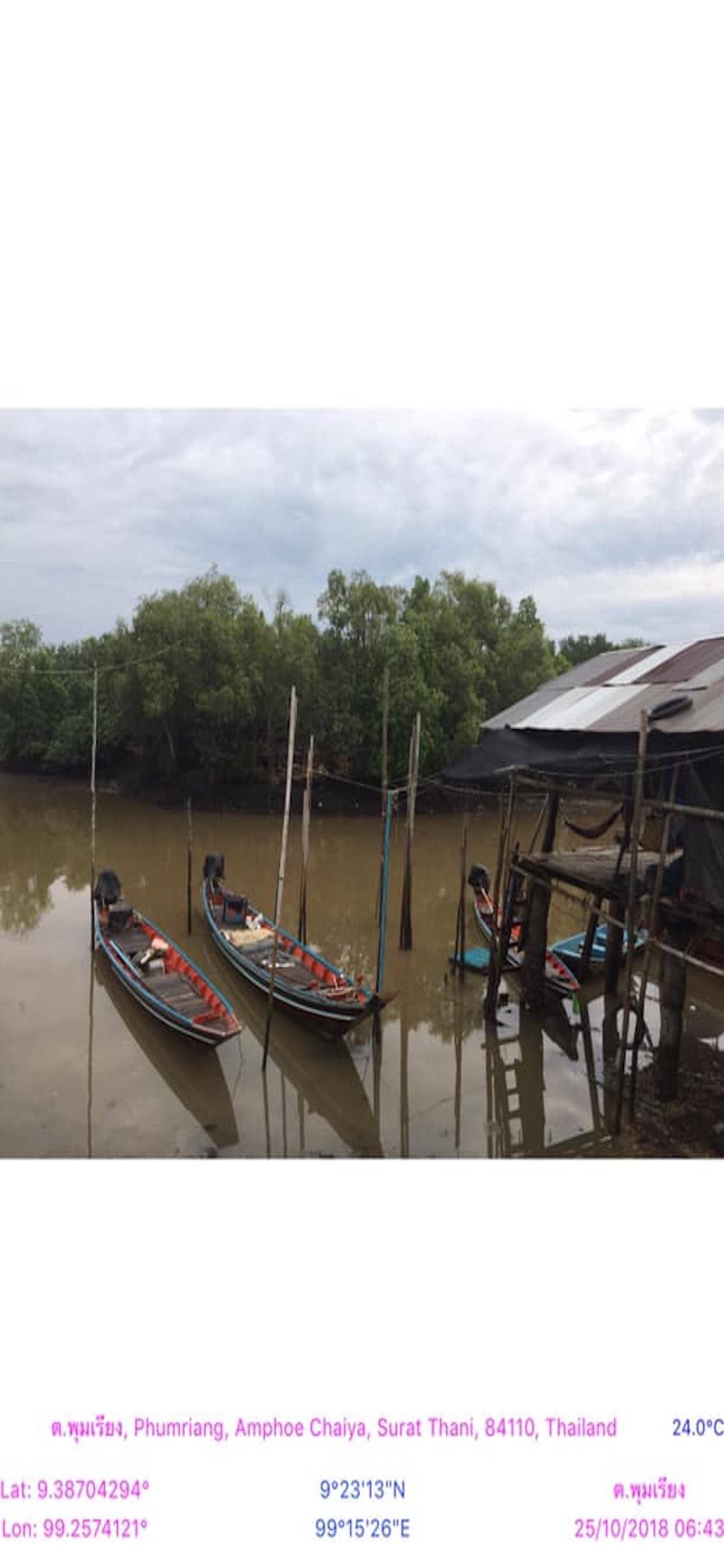
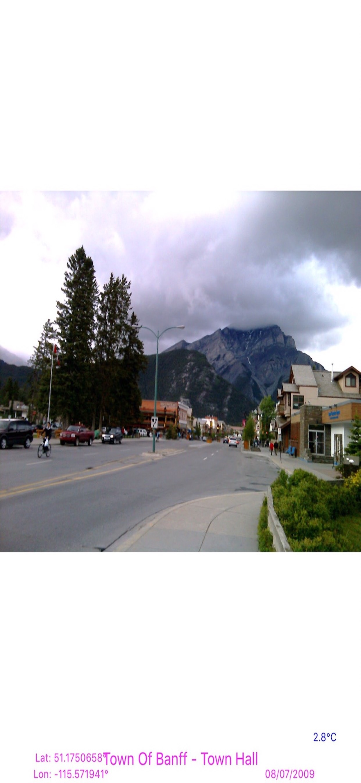
-Open app, Take photo, the current location address, place name, latitude, longitude, date, time and temperature are written at the bottom of the photo to remember, who, where and when they are.
-Set the specific place name to get exact point of interested (POI) on the photo.
-Auto save photo with embedded GPS data.
-Transform photo (pan, scale, rotate) and save to camera roll.
-Use for every check in activities, e.g. all purpose delivery, inspection jobs, start/finish outside plant jobs, tourist attraction, etc.
-Search any place on map to get the full address and place name, then stamps existing old memories photos with new date, place and location from selected place.
-retrieve coordinate latitude, longitude and address from search place.
-auto add full address Street, SubDistrict, District, City, State, ZIP, Country decoded from latitude and longitude of search place result.
- Take picture and stamp with latitude and longitude, DMS, place name, address and the current date, time and temperature.
- Import existing picture from the photo library and stamp with the place name and date.
- Capture the map screen with GPS data stamped on it.
- Save current location data, e.g. latitude and longitude, DMS, place name, and address from any place on map.
- Good for keeping picture as your memories in time.
- Upload GPS photo to other app or drive.
- Useful for all kind of prove and inspection using picture embedded with place or address, current date and time, and latitude and longitude, e.g. police patrol, court warrant delivery, check in, postman, Kerry, etc.,
- Useful for outside plant work, to initiate job or close job with picture stamping with location, latitude, longitude, DMS, address and contractor name as well as location map.
- Also useful for stamping existing old memory photos with place and date.
- Optional to hide address, location and current time.
- Stamp place name and date for old stock of photos.
- Display current temperature.
- Three colors temperature: blue (less than 20 celsius), orange (20-30 celsius) and red (> 30 celsius).
-Three colors pm2.5 pollution: green (less than 50) orange (50-100), and red (>100).
- Current location address will display automatically by detecting the current location.
How to use App
1. Address will display automatically by detecting the current location.
Tap on any GPS label item to hide it.
Single tap on map to toggle zoom in/zoom out.
Double tap on the map to toggle map type.
Tap Share button on the default map to save map with the current GPS label items and share it.
2. Tap Camera button to take photo. Tap Use Photo to save the image and we can Pinch on image to zoom in/zoom out, Pan on image to move an image, Turn image with two fingers to rotate, Double tap on image to reset.
3. Tap home button to set the new place label.
4. Tap Share button to share the current photo with embedded GPS text to other app.
5. Tap Folder button to import photo form the photo library to stamp with the user defined place and date.
6. Tap Save button to save the current screen image.
7. Tap + to return to default map view and show all GPS label items.
8. Tap airplane button to flyover current location or selected pin or search result to view amazing 3D metropolitan city.
To stamp existing photo with pace and date
1. enter search keyword.
2. select place from tableview, and click Back.
3. place name, latitude, longitude, temperature and current date time display on label and center map on selected place
4. tap on folder button to open photo from photo gallery.
5. tap on Calendar button to set the new date when that photo was taken.
6. tap Save.
7. tap New (+) button to return to current location mapview and default gps labels.
Ausblenden
Mehr anzeigen...
-Taking photo, checking in and stamping existing old memory photos with place and date.
-Long press on any location on map to get the full street address, location, temperature and pm2.5 pollution.
-Open app, Take photo, the current location address, place name, latitude, longitude, date, time and temperature are written at the bottom of the photo to remember, who, where and when they are.
-Set the specific place name to get exact point of interested (POI) on the photo.
-Auto save photo with embedded GPS data.
-Transform photo (pan, scale, rotate) and save to camera roll.
-Use for every check in activities, e.g. all purpose delivery, inspection jobs, start/finish outside plant jobs, tourist attraction, etc.
-Search any place on map to get the full address and place name, then stamps existing old memories photos with new date, place and location from selected place.
-retrieve coordinate latitude, longitude and address from search place.
-auto add full address Street, SubDistrict, District, City, State, ZIP, Country decoded from latitude and longitude of search place result.
- Take picture and stamp with latitude and longitude, DMS, place name, address and the current date, time and temperature.
- Import existing picture from the photo library and stamp with the place name and date.
- Capture the map screen with GPS data stamped on it.
- Save current location data, e.g. latitude and longitude, DMS, place name, and address from any place on map.
- Good for keeping picture as your memories in time.
- Upload GPS photo to other app or drive.
- Useful for all kind of prove and inspection using picture embedded with place or address, current date and time, and latitude and longitude, e.g. police patrol, court warrant delivery, check in, postman, Kerry, etc.,
- Useful for outside plant work, to initiate job or close job with picture stamping with location, latitude, longitude, DMS, address and contractor name as well as location map.
- Also useful for stamping existing old memory photos with place and date.
- Optional to hide address, location and current time.
- Stamp place name and date for old stock of photos.
- Display current temperature.
- Three colors temperature: blue (less than 20 celsius), orange (20-30 celsius) and red (> 30 celsius).
-Three colors pm2.5 pollution: green (less than 50) orange (50-100), and red (>100).
- Current location address will display automatically by detecting the current location.
How to use App
1. Address will display automatically by detecting the current location.
Tap on any GPS label item to hide it.
Single tap on map to toggle zoom in/zoom out.
Double tap on the map to toggle map type.
Tap Share button on the default map to save map with the current GPS label items and share it.
2. Tap Camera button to take photo. Tap Use Photo to save the image and we can Pinch on image to zoom in/zoom out, Pan on image to move an image, Turn image with two fingers to rotate, Double tap on image to reset.
3. Tap home button to set the new place label.
4. Tap Share button to share the current photo with embedded GPS text to other app.
5. Tap Folder button to import photo form the photo library to stamp with the user defined place and date.
6. Tap Save button to save the current screen image.
7. Tap + to return to default map view and show all GPS label items.
8. Tap airplane button to flyover current location or selected pin or search result to view amazing 3D metropolitan city.
To stamp existing photo with pace and date
1. enter search keyword.
2. select place from tableview, and click Back.
3. place name, latitude, longitude, temperature and current date time display on label and center map on selected place
4. tap on folder button to open photo from photo gallery.
5. tap on Calendar button to set the new date when that photo was taken.
6. tap Save.
7. tap New (+) button to return to current location mapview and default gps labels.
Screenshots


GPS Photos Lite Häufige Fragen
-
Ist GPS Photos Lite kostenlos?
Ja, GPS Photos Lite ist komplett kostenlos und enthält keine In-App-Käufe oder Abonnements.
-
Ist GPS Photos Lite seriös?
Nicht genügend Bewertungen, um eine zuverlässige Einschätzung vorzunehmen. Die App benötigt mehr Nutzerfeedback.
Danke für die Stimme -
Wie viel kostet GPS Photos Lite?
GPS Photos Lite ist kostenlos.
-
Wie hoch ist der Umsatz von GPS Photos Lite?
Um geschätzte Einnahmen der GPS Photos Lite-App und weitere AppStore-Einblicke zu erhalten, können Sie sich bei der AppTail Mobile Analytics Platform anmelden.

Benutzerbewertung
Die App ist in Frankreich noch nicht bewertet.
Bewertungsverlauf
GPS Photos Lite Bewertungen
Keine Bewertungen in Frankreich
Die App hat noch keine Bewertungen in Frankreich.
Store-Rankings
Ranking-Verlauf
App-Ranking-Verlauf noch nicht verfügbar
Kategorien-Rankings
App ist noch nicht gerankt
Schlüsselwörter
GPS Photos Lite Konkurrenten
| Name | Rezensionen | Bewertungen | Letzte Veröffentlichung | |
|---|---|---|---|---|
GPS Photo: Geotag Location
GPS Camera for Location Photo
|
0
|
|
vor 7 Monaten | |

Geo Stamp : GPS Mark on photo
GPS Tag Watermark on photo
|
0
|
|
vor 1 Monat | |

GPS camera Lite: geotag photo
GPS Map Camera for iPhone
|
0
|
|
vor 1 Woche | |

Polocam Geotagging & timestamp
Geotag & Timestamp on photo
|
0
|
|
vor 3 Monaten | |

GPS Angular Camera App
GPS Camera Photo with Location
|
0
|
|
vor 1 Woche | |

Auto Time Stamp Photo
|
0
|
|
vor 1 Jahr | |

Camera Notes
Camera as a notebook
|
0
|
|
vor 3 Jahren | |

Photo Location Editor
Edit & Set Location of Photo
|
0
|
|
vor 1 Jahr | |

GPS Camera Snapshot
SnapMap: GPS Capture
|
0
|
|
vor 1 Jahr | |

GPS Camera with Time Stamp App
Location & Date Time on photos
|
0
|
|
vor 1 Monat |
GPS Photos Lite Installationen
Letzte 30 Tage
GPS Photos Lite Umsatz
Letzte 30 TageGPS Photos Lite Einnahmen und Downloads
Gewinnen Sie wertvolle Einblicke in die Leistung von GPS Photos Lite mit unserer Analytik.
Melden Sie sich jetzt an, um Zugriff auf Downloads, Einnahmen und mehr zu erhalten.
Melden Sie sich jetzt an, um Zugriff auf Downloads, Einnahmen und mehr zu erhalten.
App-Informationen
- Kategorie
- Photo Video
- Herausgeber
- Mudarmeen Munlin
- Sprachen
- English
- Letzte Veröffentlichung
- 1.89 (vor 6 Monaten )
- Veröffentlicht am
- Dec 17, 2019 (vor 4 Jahren )
- Auch verfügbar in
- Indien, Australien, Vereinigte Staaten, Türkei, Peru, Polen, Neuseeland, Norwegen, Niederlande, Nigeria, Malaysia, Mexiko, Libanon, Kasachstan, Kuwait, Südkorea, Japan, Philippinen, Pakistan, Südafrika, Portugal, Rumänien, Russland, Saudi-Arabien, Schweden, Singapur, Thailand, Taiwan, Ukraine, Vietnam, Vereinigte Arabische Emirate, Dominikanische Republik, Argentinien, Österreich, Aserbaidschan, Belgien, Brasilien, Belarus, Kanada, Schweiz, Chile, China, Kolumbien, Tschechien, Deutschland, Dänemark, Italien, Algerien, Ecuador, Ägypten, Spanien, Finnland, Frankreich, Vereinigtes Königreich, Griechenland, Sonderverwaltungsregion Hongkong, Ungarn, Indonesien, Irland, Israel
- Zuletzt aktualisiert
- vor 1 Monat
- © 2024 AppTail.
- Unterstützung
- Privacy
- Terms
- All Apps