GPS
Peut-on utiliser l’application comme GPS une fois l’itinéraire téléchargé ? Cordialement.


Ja, GPX viewer 2 ist kostenlos herunterzuladen, enthält jedoch In-App-Käufe oder Abonnements.
✅ Die GPX viewer 2-App scheint von hoher Qualität und legitim zu sein. Die Nutzer sind sehr zufrieden.
GPX viewer 2 bietet mehrere In-App-Käufe/Abonnements, der durchschnittliche In-App-Preis beträgt 53.23 R$.
Um geschätzte Einnahmen der GPX viewer 2-App und weitere AppStore-Einblicke zu erhalten, können Sie sich bei der AppTail Mobile Analytics Platform anmelden.

Peut-on utiliser l’application comme GPS une fois l’itinéraire téléchargé ? Cordialement.
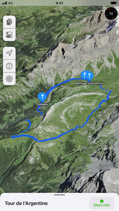
La meilleure app pour GPX selon moi… simple, léger, efficace… bravo à Jonathan pour ce beau travail… L’appli regroupe les fonctionnalités dont j’avais besoin, ni plus, ni moins… bref, impossible de m’égarer en montagne avec GPX wiever :-) et pour un prix mini… merci !
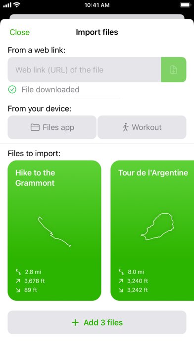
Apparemment il n’est pas possible d’ouvrir et d’afficher plusieurs fichiers en même temps sur la version IOS. Il semble que ce soit possible sur la version Androïd.
Pourquoi faire compliqué quand on peut faire simple? C’est parfait merci
L’application correspond à 200% au style que je recherche pour la randonnée. Simple, efficace, minimaliste, esthétique, pas trop gourmande. La version gratuite n’est pas tant limitante que ça et le one-time fee n’est clairement pas exorbitant. Je recommande ! Les deux fonctionnalités près sont: 1• Une fois le fichier GPX chargé, choisir la portion que l’on veut afficher (carte et élévation. Je verrais ça comme la fonctionnalité d’édition vidéo sur iOS pour raccourcir/ allonger l’enregistrement). 2• L’ajout de points de repères sur la carte. Je pense à quelque chose de très facile à mettre en place sans modifier le .gpx, mais juste en stockant en local les points avec une note (et quelques icônes/couleurs dispo serait un plus non indispensable). Je suis Dev sur des technologies Web/Mobile et pourrais peut-être apporter un coup de main là dessus. Merci pour l’app !
L’application est presque parfaite manque juste une app sur l’apple watch pour éviter de sortir le téléphone. PS j’ai pris la version payante pour vous soutenir et je serais prêt à payer un supplément si une version sur watch voit le jour :)
Très content de l’application. Autant pour le vélo que les rando à pied. Je recommande! Beaucoup plus simple et intuitif que les autres appli à abonnement. J’ai acheté la version pro sans aucun regrets.
Excellente app. Seul manquement selon moi : l’ajout de point d’intérêts. Cette fonctionnalité pourrait être disponible pour les pro (tout comme la boussole) et permettrait d’ajouter des points pour faire son propre tracé, ou compléter un tracé existant
sans n’essayer de nous embarquer dans un pseudo réseau social du randonneur. Une belle carte, une trace GPS avec ses outils et c'est tout, le top !
Je recommande cette excellente application que j’utilise depuis quelques mois. Encore un plus avec la dernière mise à jour ‘4 formats de coordonnées’ Merci au développeur !
|
Diagramm
|
Kategorie
|
Rang
|
|---|---|---|
|
Top Umsatz
|

|
27
|
|
Top Kostenlos
|

|
33
|
|
Top Kostenlos
|

|
34
|
|
Top Kostenlos
|

|
41
|
|
Top Umsatz
|

|
46
|
| Name | Rezensionen | Bewertungen | Letzte Veröffentlichung | |
|---|---|---|---|---|

GPS Tracks
GPS Tracker and Offline Maps
|
16
|
14
|
vor 1 Woche | |

Topo GPS - Topographic maps
Plan and follow gpx routes
|
0
|
|
vor 3 Wochen | |

GPX-Viewer
View GPX files
|
1
|
|
vor 3 Wochen | |

ARA GPX Viewer
|
0
|
|
vor 2 Jahren | |

Visorando Walking Routes
Outdoor GPS working offline
|
0
|
|
vor 2 Monaten | |

Open GPX Tracker
No ads, no in-app purchases
|
3
|
|
vor 1 Jahr | |

GPX Viewer PRO
Trilhas e pontos de referência
|
6
|
1
|
vor 1 Monat | |

GeoTracker Lite
GPS+Weather Tracking
|
2
|
17
|
vor 1 Monat | |

GPX Viewer
Follow tracks hiking & cycling
|
0
|
11
|
vor 2 Monaten | |

GPX Visualizar
Abra a rota em um mapa
|
0
|
|
vor 5 Monaten |
