Bad fix
Ancora problemi con l’apertura della mappa principale... bug non risolto. Peccato, perché sarebbe una buona app, molto completa


Ja, Hurricane Track ist komplett kostenlos und enthält keine In-App-Käufe oder Abonnements.
⚠️ Die Hurricane Track-App hat schlechte Bewertungen und negatives Feedback. Die Nutzer scheinen mit der Leistung oder den Funktionen unzufrieden zu sein.
Hurricane Track ist kostenlos.
Um geschätzte Einnahmen der Hurricane Track-App und weitere AppStore-Einblicke zu erhalten, können Sie sich bei der AppTail Mobile Analytics Platform anmelden.

Ancora problemi con l’apertura della mappa principale... bug non risolto. Peccato, perché sarebbe una buona app, molto completa
Fantastic fix! Now I can no longer open the application...! Please fix the fix.
Questa applicazione è molto lenta e non esiste la lingua Italiana , va in crash facilmente
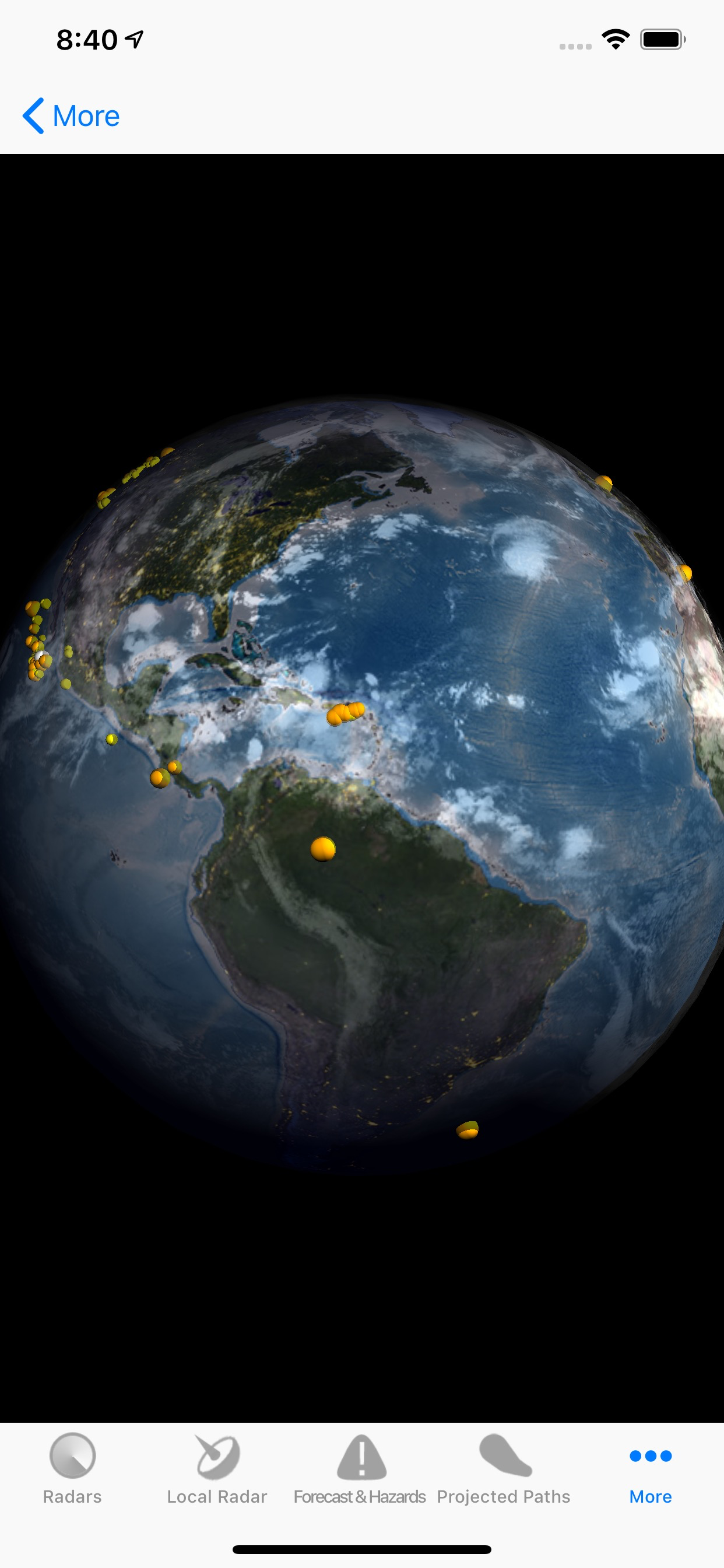
Seven years ago, this was a hurricane app for the Atlantic only until I approached the developer to make some overall positive changes to this app to include the Eastern and Central Pacific including a radar map for the Hawaiian Islands. Since that time, we’ve seen several GOES satellites come and go in which we lost some key features over the years. On March 1,2022, NOAA launched the new GOES-T Satellite to be renamed to GOES-18 once it reaches it’s final orbit, which it did on May 13-22, 2022 after some orbital adjustments. This satellite will be renamed again in May 2023 to GOES-West after the next satellite launch here in a few months in the cue. Some of those key features will come back with the next satellite launch such as the world Sea Surface Temperature Map( SST) Interactive and the South Eastern Pacific Radar Map Interactive with the next several weeks. This entire app is interactive and it much easier to sense the direction, speed, size and intensity of a named hurricane. It’s a lot of labor and hard work involved to connect, match up data and update this interactive real time hurricane radar maps to this new GOES-18 Satellite feed but you will notice that these interactive Doppler Radar maps are like no other in Apple’s App Store currently. Currently, the Hawaiian Islands are under hurricane threats from Bonnie, which was downgraded and Darby, which was just upgraded to a CAT 3 but will hopefully pass south of the Hawaiian Islands this weekend while we are experiencing Kings Tides. On this Saturday, July 16 from 9am to 12noon, the Makani ‘Ino ARES Hurricane Drill will happen at the same time along with the RIMPAC 2022 Military Exercise to add some possible realistic data and Amateur Radio EmComm Communications that couldn’t have any better timing than this to add some realism to these important exercises. With that said, this Hurricane App with be playing a key role with us doing mobile operations including on several military bases this coming Saturday morning. As the Net Controller for the Honolulu NWS SKYWARN Program at the University of Hawaii-Manoa Campus, this app is going to play a vital role for me while on the road and while going to each mobile preplanned location on my iPhone. Please support this app as improvements will be made over the next couple of months. A big Mahalo!
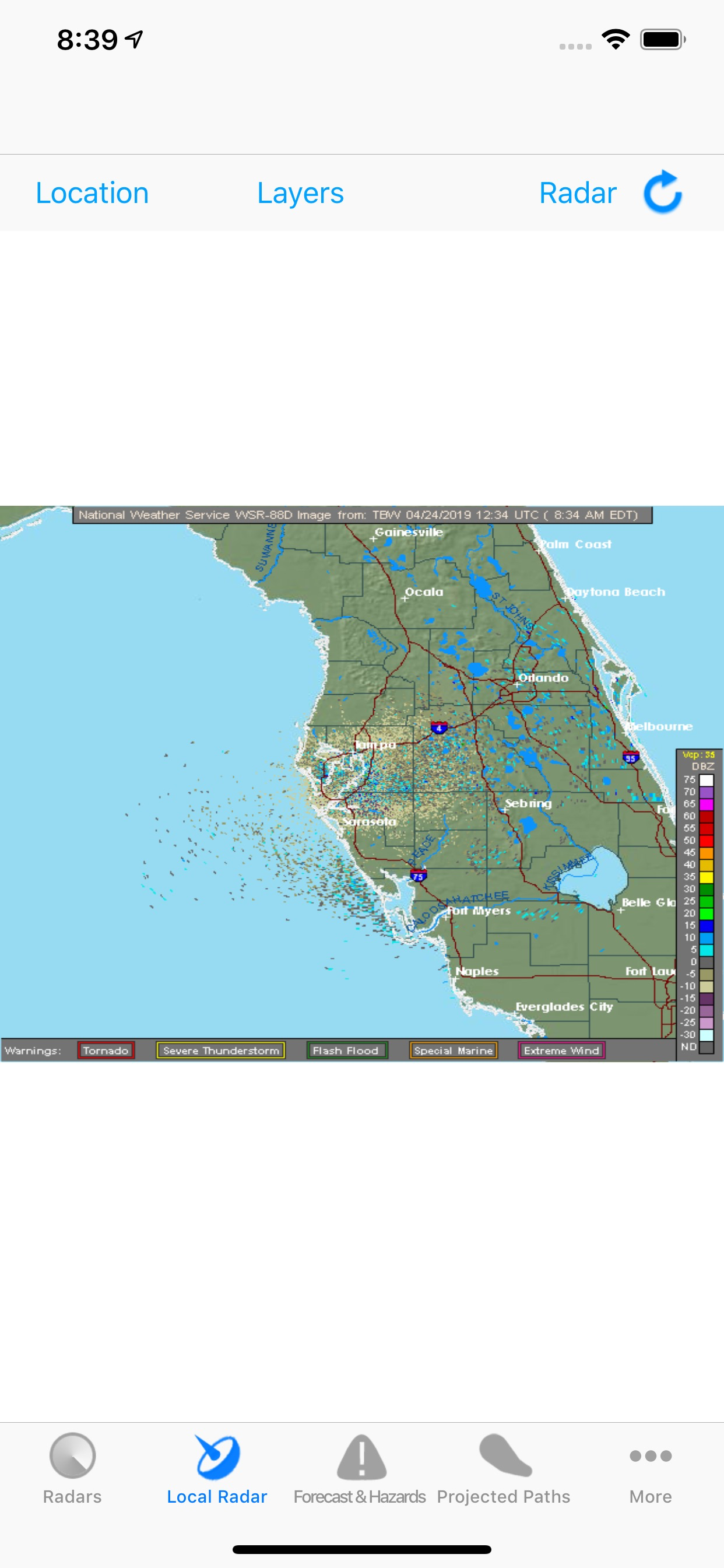
Every time I want to see the predicted hurricane track, it has to “load” 30-50 images. Why? Just show the hurricane of interest (let me “pin” it) Also, in the hurricane forecast and discussion, the entire text is on ONE LINE. This is impossible to read.
Hurricane Dorian is almost non-existent on this app. This was my favorite hurricane app for years but something has drastically change. When you open the app it automatically goes to the global weather which would be good if you could actually interact with it and zoom in or select an area of interest... Please fix
On the main map, it shows a track for Isaac while completely omitting tracks for Florence, Helene and Gordon! Too much missing, yet vital, weather and hurricane info. Deleting.
Removing now. Forces to load 50 maps EVERY time I open it and every time I tap to choose a radar etc. And is worst data hog of any weather type app I have ever used and maybe any app. It just used about 40 megs of data in less than one minute!
First names storm of the year, so I was looking forward to opening up this app and tracking the storm. Of course, the app won’t open. It goes to the loading screen then crashes.
You must fix the lighting tab because when you click on the tab the app goes off. That is not supposed to happen. I just downloaded this app and I give it four stars. Can you also have in the radar maps Atlantic and Pacific areas. Can you also go through the entire app and see what tabs are work and which one are not working and fix then all. Make the app more realistic on everything that is in it and possibly add new features.
|
Diagramm
|
Kategorie
|
Rang
|
|---|---|---|
|
Top Kostenlos
|

|
15
|
|
Top Kostenlos
|

|
18
|
|
Top Kostenlos
|

|
28
|
|
Top Kostenlos
|

|
43
|
|
Top Kostenlos
|

|
48
|
| Name | Rezensionen | Bewertungen | Letzte Veröffentlichung | |
|---|---|---|---|---|
Gulf Hurricane Tracker
|
0
|
|
vor 1 Jahr | |

Tropical Hurricane Tracker
|
0
|
|
vor 1 Woche | |

Florida Hurricane Tracker
|
0
|
|
vor 1 Jahr | |

#WEATHER
Forecast & Hurricane Tracker
|
0
|
|
vor 4 Monaten | |

Ciclone - tempeste tracker
Satellitari Radar
|
9
|
1
|
vor 4 Monaten | |

Atlantic Hurricane Tracker
|
0
|
|
vor 1 Jahr | |

OBX Hurricane Tracker
|
0
|
|
vor 1 Jahr | |
Storm Tracker Weather Radar
|
0
|
|
vor 1 Jahr | |
Pacific Hurricane Tracker
|
0
|
|
vor 1 Jahr | |

Hurricane Tracker US
US Storm tracker
|
0
|
|
vor 1 Woche |
