IGNrando' – France hiking maps

Hiking & cycling with IGN maps

Veröffentlicht von: Ubicarta

Beschreibung

IGNrando’ is a French collaborative platform offering curated data and services related to outdoor activities.
RICH DATA OFFER
• Tens of thousands of available routes accross Metropolitan and Overseas France
• Choose the activity, difficulty and length to find routes around you or near any other place
• Download or mark as favorite the desired routes or POIs
MAPS & LAYERS IN FREE ACCESS (with internet connection)
• Plan IGN: most updated map, suitable for all activities
• Aerial photos (IGN)
• OpenStreetMap Outdoors: world map with hiking routes & contour lines
• OpenCycleMap: world map with cycling routes & contour lines
∙ Spain IGN map
∙ Swisstopo map
∙ Emergency calls (112) mobile network coverage map for France
∙ Winter trails (in collaboration with the Petzl Foundation)
∙ OpenSnowMap
GPS GUIDING ALONG ROUTES
• See your progression on the map and on the elevation profile
• Get alerted if you exit the route
• Get notified of upcoming POIs or route info points (available soon)
GPS TRACKING AND DATA CREATION
• Record your own routes using GPS
• Quickly create routes on-device with the automatic routing tool that follows roads and paths (online only, with subscription)
• Create Points of interest
• Export Routes or Points to save them locally (Files app) or share them
• Send your routes to ignrando.fr for backup or to publish them
OFFLINE USE
• The GPS keeps working even without internet: see your position on the map, use GPS guiding and record routes
• Downloaded routes: descriptions, photos and guiding remain accessible
• Downloaded maps (with subscription)
USEFUL TIP: Enabling Airplane Mode or disabling Mobile Data improves battery life, without affecting the Location Services (GPS)

IGN MAPS SUBSCRIPTION
• Create routes with pedestrian and vehicle routing
• View & download the following maps & layers:
∙ All free version maps
∙ IGN maps (various scales)
∙ IGN 1:25k topo maps (Top 25): the famous French topographical maps available at all zoom levels
∙ 1950 IGN maps
∙ Military maps (1820-1866)
∙ ICAO aeronautical charts
∙ France mobile network operators coverage maps
∙ Slopes > 30° (useful for winter activites)
∙ Cadastral parcels layer
∙ DFCI grid (forest fire protection grid)
• Drones flight restriction areas
∙ Roads & paths layer (only available with Aerial photos)

IGNrando' store subscription
• Linked to IGNrando' account
• No automatic renewal
• Can be used on 3 devices at the same time
App Store subscription
• Linked to Apple account
• Automatic renewal unless cancelled at least 24 hours before the end of the current period
• Auto-renewal may be turned off by going to the user's Account Settings after purchase
• Any unused portion of a free trial period will be forfeited when the user purchases a subscription
WARNING: Ubicarta or IGN cannot refund subscriptions purchased on the App Store, only Apple can, at its sole discretion
Ausblenden Mehr anzeigen...

In-App-Käufe

Abonnement Cartes IGN Liberté
CHF 17.00

Screenshots

IGNrando' Häufige Fragen

  • Ist IGNrando' kostenlos?

    Ja, IGNrando' ist kostenlos herunterzuladen, enthält jedoch In-App-Käufe oder Abonnements.

  • Ist IGNrando' seriös?

    ⚠️ Die IGNrando'-App hat schlechte Bewertungen und negatives Feedback. Die Nutzer scheinen mit der Leistung oder den Funktionen unzufrieden zu sein.

    Danke für die Stimme

  • Wie viel kostet IGNrando'?

    IGNrando' bietet mehrere In-App-Käufe/Abonnements, der durchschnittliche In-App-Preis beträgt CHF 17.00.

  • Wie hoch ist der Umsatz von IGNrando'?

    Um geschätzte Einnahmen der IGNrando'-App und weitere AppStore-Einblicke zu erhalten, können Sie sich bei der AppTail Mobile Analytics Platform anmelden.

Benutzerbewertung

4.41 von 5

547 Bewertungen in Schweiz

5 star
372
4 star
100
3 star
27
2 star
16
1 star
29
Bewertungsverlauf

IGNrando' Bewertungen

Ça plante toujours

PieroMouss on

Schweiz

Totalement instable ! Ça plante au boit de 2 minutes

Gut, bitte optimieren

Jagdriver on

Schweiz

Die Karten sind top, die Darstellung der POIs jedoch sehr rudimentär. Bitte schaut wie bei "TopoGPS" die POIs angepasst werden können, so sollte es sein, Danke!

Wenig nützlich

Tester 0987 on

Schweiz

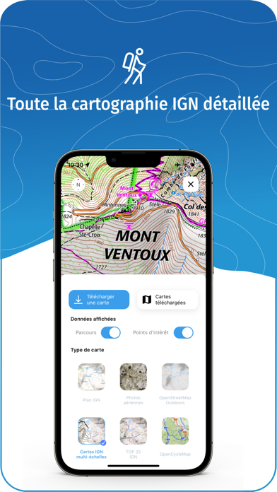
Das Kartenmaterial ist veraltet. Die Wege sind nicht eingezeichnet.

Pas d’acces au top25

Natouille67 on

Schweiz

Tres decue

Very complicated!

P the climber on

Schweiz

Compared with say Swisstopo, this is very unclear. Not sure if and when a map is downloaded or not, can’t work out how to give my maps name. Not user friendly!

Unzuverlässig, langsam, dauernd Störungen

johannes48 on

Schweiz

Obwohl ich viel in Frankreich wandere, ist die ign-App für mich unbrauchbar. Sie ist trotz schnellem Internet extrem langsam und in den Funktionen sehr unzuverlässig. Manchmal werden trotz intakter Internetverbindung keine Kacheln heruntergeladen. Auch kommt es häufig zum Abbruch der Verbindung und die App steigt aus. Gehe jetzt wieder analog wandern mit Karten aus Papier!

Suppression de tracés?

kapitou on

Schweiz

Je n’arrive pas à supprimer des tracés importés dans l’application pour smartphone. Quand on a plusieurs tracés dans la même région, impossible de les différencier, ils ont la même couleur et s’ils se superposent , difficile de s’orienter.

Très bien

HighVaud on

Schweiz

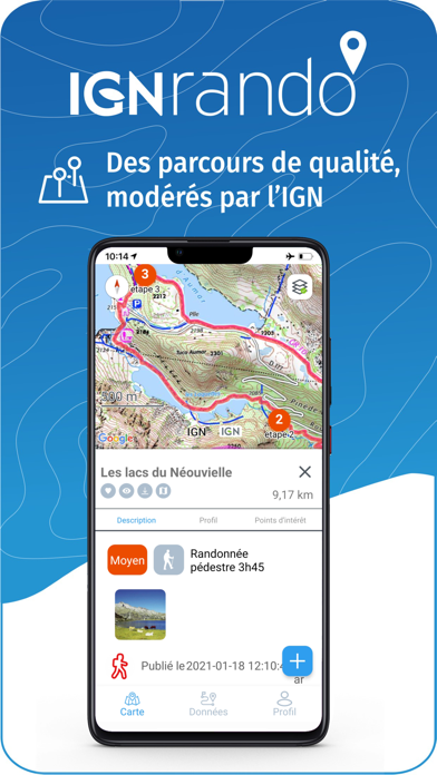
Pour chercher des chemins et découvrir des lieux inconnus

Application bourrée de but

Jo@2020@20 on

Schweiz

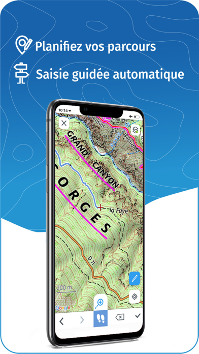
- L’utilisateur voir des messages avec les string-id - la légende apparaît et on est obligé de tuer l’app et redémarrer - pour ajouter un point sur un parcours on doit cliquer sur l’icône loupe. J’aurais envoyé un rapport de bug, mais on point ou on es est, on a voit déjà 5 bugs gênants pour découvrir les fonctions de base de l’app en 3 minutes. Il faut faire pression avec un commentaire public. Vous n’avez très visiblement ni inclus d’UX, ni fait de tests.

Naze

Disco Fever 42 on

Schweiz

Vraiment. Minabl

Store-Rankings

Ranking-Verlauf
Kategorien-Rankings
Diagramm
Kategorie
Rang
Top Umsatz
44
Top Umsatz
45
Top Umsatz
77
Top Umsatz
78
Top Kostenlos
123

Schlüsselwörter

IGNrando' Konkurrenten

Name
Iphigénie | The Hiking Map App
IGN maps, hiking, outdoor
SityTrail
Hiking Trail GPS Offline Maps
OutDoors GPS France - IGN Maps
Plan Hiking & Biking Routes
Visorando – Wanderideen
Wander-GPS mit Offline-Modus
Geovelo: Fahrrad GPS
Fahrrad-Navigation per GPS
GPX viewer
The paper map reinvented
Hika - Hiking trails and maps
Hike and walk with GPS routes
Les Pépites de France
Cartes IGN
Découvrez la France autrement
MaRando – FFRandonnée
Sentiers, promenades, GR, GPS

IGNrando' Installationen

Letzte 30 Tage

IGNrando' Umsatz

Letzte 30 Tage

IGNrando' Einnahmen und Downloads

Gewinnen Sie wertvolle Einblicke in die Leistung von IGNrando' mit unserer Analytik.
Melden Sie sich jetzt an, um Zugriff auf Downloads, Einnahmen und mehr zu erhalten.