iMapIt Lite

Measure lands with GPS

Veröffentlicht von: Marcus Silva

Beschreibung

Use your iPhone / iPad's GPS to map, measure or simply record places important to you. Your device will be a GPS receiver and will collect geographic coordinates wherever you are. GPS needs satellite’s visibility. Thus, the more open your space, the better the accuracy of measurements.
* Geographic coordinates collection formats:
. Points - Mark specific places with a point, such as the place you most like to go to, or the starting point of a race, or even the point where you saw a rare bird;
. Lines or paths - A sequence of points forming a line to mark a trail where you have walked, or the path you have taken on a run, or the path to your new house, either the location of a new fence you want to build. All mapped lines are measured for you in metric and imperial units;
. Areas or polygons - A sequence of points, forming a closed region, to mark land that you are interested in buying, or show the map of your land, or measure the outline of your new house, or delimit the region where you want to build a pool. All mapped areas are calculated for you in metric, imperial and Thai units;
The LITE version measures line’s length or polygon’s area of your FIRST survey only.
* How to collect coordinates:
. Manually: You position yourself and tap the MapIt button to collect a coordinate;
. Automatically by Time: A coordinate is collected at each defined time interval;
. Automatically by Distance: A coordinate is collected at each interval of a pre-defined distance;
. Automatically by Direction: A coordinate is collected each time you change the direction of your displacement at an angle greater than a defined limit;
* Presentation within iMapIt:
Points, lines and polygons can be represented by different types of pins, colors, strokes and fills.
* Export your surveys:
. Available only in Pro version;
* Editing functions of surveys performed:
. Feature duplication;
. Union of existing features;
. Division of a feature in two;
. Deletion of unwanted coordinates;
. Automatic cleaning of unnecessary points;
. Move a feature to a new project;
Disclaimer on the accuracy of the surveys:
All points, paths or areas are surveyed using the GPS accuracy of your device. This is not a professional precision GPS equipment. So your surveys may vary when compared to the actual dimensions.
Restrictions of the LITE version:
The export of collected data is not allowed.
The length of the paths and the size of the mapped areas are calculated only for the very FIRST survey.
Ads are presented in map screen.
Ausblenden Mehr anzeigen...

Screenshots

iMapIt Lite Häufige Fragen

  • Ist iMapIt Lite kostenlos?

    Ja, iMapIt Lite ist komplett kostenlos und enthält keine In-App-Käufe oder Abonnements.

  • Ist iMapIt Lite seriös?

    Nicht genügend Bewertungen, um eine zuverlässige Einschätzung vorzunehmen. Die App benötigt mehr Nutzerfeedback.

    Danke für die Stimme

  • Wie viel kostet iMapIt Lite?

    iMapIt Lite ist kostenlos.

  • Wie hoch ist der Umsatz von iMapIt Lite?

    Um geschätzte Einnahmen der iMapIt Lite-App und weitere AppStore-Einblicke zu erhalten, können Sie sich bei der AppTail Mobile Analytics Platform anmelden.

Benutzerbewertung
Die App ist in Nigeria noch nicht bewertet.
Bewertungsverlauf

iMapIt Lite Bewertungen

O melhor app

Criastiano on

Brasilien

O único que app que realmente funciona no iPhone, com ele consigo medir terrenos de qualquer formato, e distância extensas. Nota 10!

Merda

Alghisfi on

Brasilien

Uma bosta

Bom

Gau Salles on

Brasilien

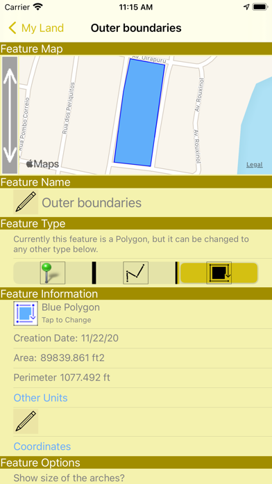
Poderia ser melhor se salvasse as coordenadas, mesmo na versão lite.

Não funciona a versão teste

Paimauro on

Brasilien

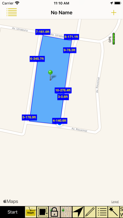
Baixei o programa, como pode ser visto na imagem de pre-visualização ele tem suas funções disponíveis pra teste, o que não acontece... Não recomendo

Muito boa

Marcus Badu on

Brasilien

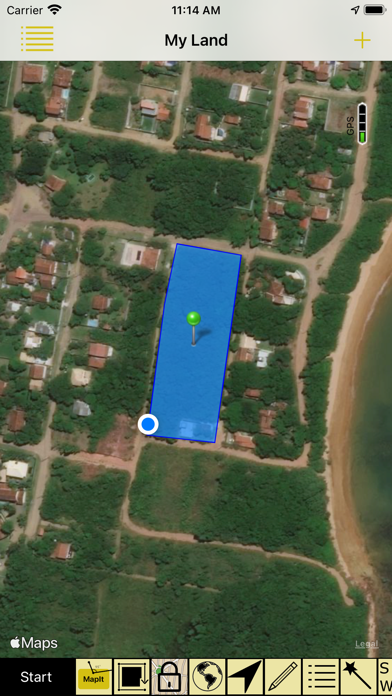
Consigo medir uma área no sítio só com o GPS do meu iPhone. Muito bacana.

Store-Rankings

Ranking-Verlauf
App-Ranking-Verlauf noch nicht verfügbar
Kategorien-Rankings
App ist noch nicht gerankt

iMapIt Lite Konkurrenten

Name
My GPS Coordinates
Planimeter 2 land measure
field area and survey on maps
Agricision onTrak
Controller App for onTrak GPS
Daily Report App
Engineering and Construction
ConstruCalc
Cropwise Protector
GIS Lite
Explore space
Fields Area Measurement
Measure Fields & Area
GPS Measure - Area & Length
Measure field area & perimeter
Geo Survey - Land Survey
Geo Survey - Area and Distance

iMapIt Lite Installationen

Letzte 30 Tage

iMapIt Lite Umsatz

Letzte 30 Tage

iMapIt Lite Einnahmen und Downloads

Gewinnen Sie wertvolle Einblicke in die Leistung von iMapIt Lite mit unserer Analytik.
Melden Sie sich jetzt an, um Zugriff auf Downloads, Einnahmen und mehr zu erhalten.