
Beschreibung
Use your iPhone / iPad's GPS to map, measure or simply record places important to you. Your device will be a GPS receiver and will collect geographic coordinates wherever you are. GPS needs satellite’s visibility. Thus, the more open your space, the better the accuracy of measurements.
* Geographic coordinates collection formats:
. Points - Mark specific places with a point, such as the place you most like to go to, or the starting point of a race, or even the point where you saw a rare bird;
. Lines or paths - A sequence of points forming a line to mark a trail where you have walked, or the path you have taken on a run, or the path to your new house, either the location of a new fence you want to build. All mapped lines are measured for you in metric and imperial units;
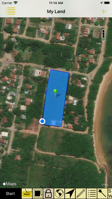
. Areas or polygons - A sequence of points, forming a closed region, to mark land that you are interested in buying, or show the map of your land, or measure the outline of your new house, or delimit the region where you want to build a pool. All mapped areas are calculated for you in metric, imperial and Thai units;
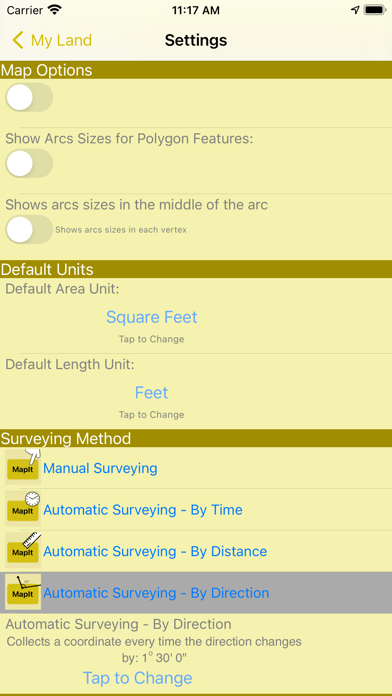
* How to collect coordinates:
. Manually: You position yourself and tap the MapIt button to collect a coordinate;
. Automatically by Time: A coordinate is collected at each defined time interval;
. Automatically by Distance: A coordinate is collected at each interval of a pre-defined distance;
. Automatically by Direction: A coordinate is collected each time you change the direction of your displacement at an angle greater than a defined limit;
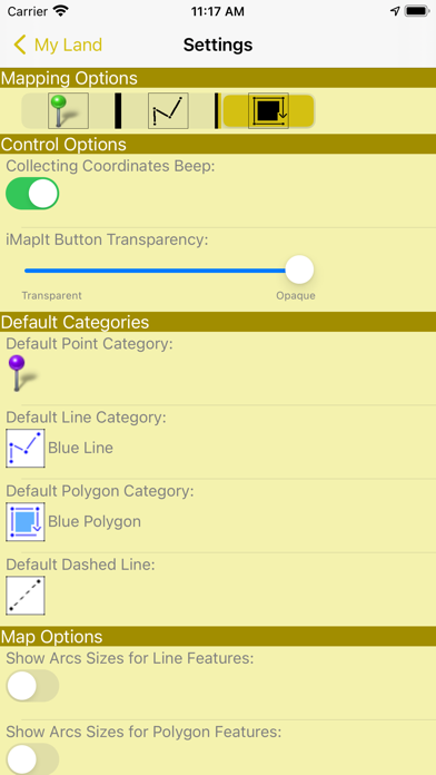
* Presentation within iMapIt:
Points, lines and polygons can be represented by different types of pins, colors, strokes and fills.
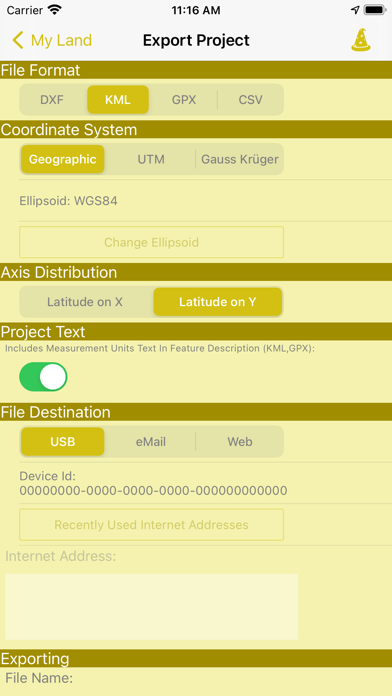
* Export your surveys:
. In these formats: DXF, KML, GPX or CSV;
. Using these projections: UTM or Gauss Krüger, or directly the collected geographical coordinates;
. Sending via: eMail, or directly from your device via iTunes (cable), or even more professionally, transferring to a Web server previously prepared to receive them;
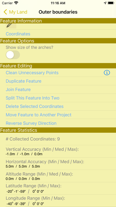
* Editing functions of surveys performed:
. Feature duplication;
. Union of existing features;
. Division of a feature in two;
. Deletion of unwanted coordinates;
. Automatic cleaning of unnecessary points;
. Move a feature to a new project;
Disclaimer on the accuracy of the surveys:
All points, paths or areas are surveyed using the GPS accuracy of your device. This is not a professional precision GPS equipment. So your surveys may vary when compared to the actual dimensions.
Ausblenden
Mehr anzeigen...
* Geographic coordinates collection formats:
. Points - Mark specific places with a point, such as the place you most like to go to, or the starting point of a race, or even the point where you saw a rare bird;
. Lines or paths - A sequence of points forming a line to mark a trail where you have walked, or the path you have taken on a run, or the path to your new house, either the location of a new fence you want to build. All mapped lines are measured for you in metric and imperial units;
. Areas or polygons - A sequence of points, forming a closed region, to mark land that you are interested in buying, or show the map of your land, or measure the outline of your new house, or delimit the region where you want to build a pool. All mapped areas are calculated for you in metric, imperial and Thai units;
* How to collect coordinates:
. Manually: You position yourself and tap the MapIt button to collect a coordinate;
. Automatically by Time: A coordinate is collected at each defined time interval;
. Automatically by Distance: A coordinate is collected at each interval of a pre-defined distance;
. Automatically by Direction: A coordinate is collected each time you change the direction of your displacement at an angle greater than a defined limit;
* Presentation within iMapIt:
Points, lines and polygons can be represented by different types of pins, colors, strokes and fills.
* Export your surveys:
. In these formats: DXF, KML, GPX or CSV;
. Using these projections: UTM or Gauss Krüger, or directly the collected geographical coordinates;
. Sending via: eMail, or directly from your device via iTunes (cable), or even more professionally, transferring to a Web server previously prepared to receive them;
* Editing functions of surveys performed:
. Feature duplication;
. Union of existing features;
. Division of a feature in two;
. Deletion of unwanted coordinates;
. Automatic cleaning of unnecessary points;
. Move a feature to a new project;
Disclaimer on the accuracy of the surveys:
All points, paths or areas are surveyed using the GPS accuracy of your device. This is not a professional precision GPS equipment. So your surveys may vary when compared to the actual dimensions.
Screenshots


iMapIt Pro Häufige Fragen
-
Ist iMapIt Pro kostenlos?
iMapIt Pro ist nicht kostenlos (es kostet 4.99), enthält jedoch keine In-App-Käufe oder Abonnements.
-
Ist iMapIt Pro seriös?
Nicht genügend Bewertungen, um eine zuverlässige Einschätzung vorzunehmen. Die App benötigt mehr Nutzerfeedback.
Danke für die Stimme -
Wie viel kostet iMapIt Pro?
Der Preis von iMapIt Pro beträgt 4.99.
-
Wie hoch ist der Umsatz von iMapIt Pro?
Um geschätzte Einnahmen der iMapIt Pro-App und weitere AppStore-Einblicke zu erhalten, können Sie sich bei der AppTail Mobile Analytics Platform anmelden.

Benutzerbewertung
Die App ist in Algerien noch nicht bewertet.
Bewertungsverlauf
iMapIt Pro Bewertungen
Keine Bewertungen in Algerien
Die App hat noch keine Bewertungen in Algerien.
Store-Rankings
Ranking-Verlauf
Kategorien-Rankings
|
Diagramm
|
Kategorie
|
Rang
|
|---|---|---|
|
Top Bezahlt
|

|
70
|
|
Top Bezahlt
|

|
79
|
|
Top Bezahlt
|
|
143
|
|
Top Bezahlt
|

|
162
|
|
Top Bezahlt
|

|
248
|
iMapIt Pro Installationen
Letzte 30 Tage
iMapIt Pro Umsatz
Letzte 30 TageiMapIt Pro Einnahmen und Downloads
Gewinnen Sie wertvolle Einblicke in die Leistung von iMapIt Pro mit unserer Analytik.
Melden Sie sich jetzt an, um Zugriff auf Downloads, Einnahmen und mehr zu erhalten.
Melden Sie sich jetzt an, um Zugriff auf Downloads, Einnahmen und mehr zu erhalten.
App-Informationen
- Kategorie
- Productivity
- Herausgeber
- Marcus Silva
- Sprachen
- English, French, Portuguese
- Letzte Veröffentlichung
- 4.1 (vor 3 Jahren )
- Veröffentlicht am
- Dec 10, 2011 (vor 13 Jahren )
- Auch verfügbar in
- Brasilien, Vereinigte Staaten, Neuseeland, Belgien, Deutschland, Kanada, China, Malaysia, Pakistan, Philippinen, Peru, Nepal, Norwegen, Niederlande, Nigeria, Russland, Mexiko, Litauen, Libanon, Kasachstan, Kuwait, Südkorea, Polen, Portugal, Rumänien, Israel, Saudi-Arabien, Schweden, Singapur, Thailand, Tunesien, Türkei, Taiwan, Ukraine, Usbekistan, Vietnam, Südafrika, Ecuador, Armenien, Argentinien, Österreich, Australien, Aserbaidschan, Bahrain, Belarus, Schweiz, Chile, Kolumbien, Zypern, Tschechien, Dänemark, Dominikanische Republik, Algerien, Japan, Estland, Ägypten, Spanien, Finnland, Frankreich, Vereinigtes Königreich, Griechenland, Sonderverwaltungsregion Hongkong, Kroatien, Ungarn, Indonesien, Irland, Vereinigte Arabische Emirate, Indien, Italien
- Zuletzt aktualisiert
- vor 1 Woche
This page includes copyrighted content from third parties, shared solely for commentary and research in accordance with fair use under applicable copyright laws. All trademarks, including product, service, and company names or logos, remain the property of their respective owners. Their use here falls under nominative fair use as outlined by trademark laws and does not suggest any affiliation with or endorsement by the trademark holders.
- © 2025 AppTail.
- Unterstützung
- Privacy
- Terms
- All Apps