App ist vorübergehend nicht verfügbar

NOAA Nautical Charts & Map

Marine Navigation Map Download

Veröffentlicht von: Amni

Beschreibung

The premium and best app for Nautical Navigation Charts and Maps:
* 1000+ NOAA Raster Navigational Charts (RNC) available for download and for offline use. RNC are high resolution, full-color, geo-referenced, digital images of NOAA paper nautical charts.
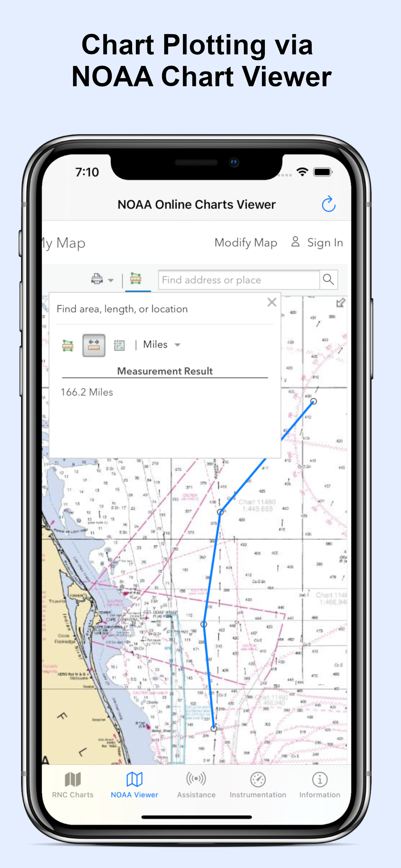
* 1000+ NOAA Navigational Charts for online use that includes GPS location, navigation plotting and more.
* Basic instrumentation - GPS location, Longitude, Latitude and Device Compass.
* Assitance Support - Link to Navigation Center, Radio Information.for Boaters.
Additional information about the charts and data provided with this app:
NOAA RNC® charts are full-color, geo-referenced, digital images of NOAA paper nautical charts.
RNCs can be used with global positioning system (GPS) enabled electronic chart systems or other “chart plotter” display systems to provide real-time vessel positioning.
NOAA RNCs comply with the International Hydrographic Organization RNC Product Specification.
RNCs are approved for use by IMO ECDIS mandated vessels only if adequate ENC data is not available. Since complete ENC coverage is available in all U.S. waters, vessels required to use ECDIS may not navigate with NOAA RNCs.
NOAA RNCs DO NOT meet USCG chart carriage requirements for commercial vessels.
NOAA RNCs may be downloaded free from the NOAA chart locator or the NOAA nautical chart catalog.
----------
Electronic Navigational Charts (ENC) are vector data sets that support all types of marine navigation. Originally designed for large commercial vessels using a sophisticated navigational computer called an Electronic Chart Display and Information System (ECDIS), ENCs are now also being used on simpler electronic chart systems and “chart plotters” on many types of ships and by recreational boaters. NOAA ENCs help provide real-time ship positioning, as well as collision and grounding avoidance.
NOAA ENCs comply with the International Hydrographic Organization ENC Product Specification. ENCs are produced around the world by many different countries’ national hydrographic or charting agencies. NOAA maintains more than 1,000 NOAA ENC® datasets over U.S. coastal waters and the Great Lakes. The U.S. Army Corps of Engineers produces a similar product, called Inland ENC (IENC) for many U.S. rivers.
Ausblenden Mehr anzeigen...

Screenshots

NOAA Nautical Charts & Map Häufige Fragen

  • Ist NOAA Nautical Charts & Map kostenlos?

    Ja, NOAA Nautical Charts & Map ist komplett kostenlos und enthält keine In-App-Käufe oder Abonnements.

  • Ist NOAA Nautical Charts & Map seriös?

    🤔 Die Qualität der NOAA Nautical Charts & Map-App ist gemischt. Einige Nutzer sind zufrieden, während andere Probleme melden. Ziehen Sie in Betracht, einzelne Bewertungen für mehr Kontext zu lesen.

    Danke für die Stimme

  • Wie viel kostet NOAA Nautical Charts & Map?

    NOAA Nautical Charts & Map ist kostenlos.

  • Wie hoch ist der Umsatz von NOAA Nautical Charts & Map?

    Um geschätzte Einnahmen der NOAA Nautical Charts & Map-App und weitere AppStore-Einblicke zu erhalten, können Sie sich bei der AppTail Mobile Analytics Platform anmelden.

Benutzerbewertung
Die App ist in Italien noch nicht bewertet.
Bewertungsverlauf

NOAA Nautical Charts & Map Bewertungen

Another Don’t do it

Rawcool on

Vereinigte Staaten

I’ve been over this app 1000 times and I still can’t get it to download anything other than a blank page on the chart I select. I clicked download, it says downloaded, the file appears nowhere on my iPad and when I try to open it I get the blank page that downloaded. contact for the developer is nonexistent.

Crashes every time

hnewd on

Vereinigte Staaten

Crashes every time I try to download a chart. How do I get my money back?

Could be good if it could do the 1 thing it’s supposed to do

Robbobak on

Vereinigte Staaten

Paid for this app. Seemed simple and uses NOAA charts that are freely available. Trying to download a map causes the app to crash. Can’t even do the one thing it’s designed to do. Restarted the phone and it continues. I hope there’s a fix soon. Not a great start.

Great maps

don043 on

Vereinigte Staaten

Great quality maps

Great for sailing

trgr11112 on

Vereinigte Staaten

The hi-resolution chart are helpful

Good

obosiki on

Vereinigte Staaten

It a good app I love it

Awesome maps

mickeyyo01 on

Vereinigte Staaten

High quality maps!!

Great app!

VanceVance on

Vereinigte Staaten

The most convenient way to interact with noaa maps. Good quality works well.

Democratizing the marine space

John459274 on

Vereinigte Staaten

I love how this is democratizing the charting space and away from big corporations that you need to pay over 50 or 100 to get a limited sets of maps. Keep up the good work.

Don’t do it

Chasser0000012838474 on

Vereinigte Staaten

Did not have they charts needed. Orientation of charts they did have was so poor it was useless. Made you pay prior to seeing how crappy the ap was.

NOAA Nautical Charts & Map Konkurrenten

Name
Seawell Navigation Charts
Sea Navigation Marine Offline
Seawell Caribbean Islands GPS
Marine Offline Charts with GPS
Nautical Charts & Maps
Nautical Charts & Marine Maps
Quick E6B
E6B App for General Aviation
iSailGPS : NOAA USA RNC Charts
Marine Nautical Chart Plotter
Flytomap carta nautica e laghi
Carte Mappe Copertura Mondiale
Rome Tour - Travel Guide
Works offline
Hip Charts
NOAA ENC Charts
SeaNav US
HD Marine Navigation & Charts
ApexDrives

NOAA Nautical Charts & Map Installationen

Letzte 30 Tage

NOAA Nautical Charts & Map Umsatz

Letzte 30 Tage

NOAA Nautical Charts & Map Einnahmen und Downloads

Gewinnen Sie wertvolle Einblicke in die Leistung von NOAA Nautical Charts & Map mit unserer Analytik.
Melden Sie sich jetzt an, um Zugriff auf Downloads, Einnahmen und mehr zu erhalten.