It seems incomplete
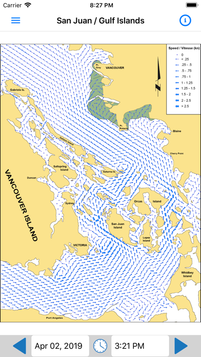
Where is the chart that shows the currents north of Gabriola to Campbell river?

Ja, PNW Current Atlas ist kostenlos herunterzuladen, enthält jedoch In-App-Käufe oder Abonnements.
🤔 Die Qualität der PNW Current Atlas-App ist gemischt. Einige Nutzer sind zufrieden, während andere Probleme melden. Ziehen Sie in Betracht, einzelne Bewertungen für mehr Kontext zu lesen.
PNW Current Atlas bietet mehrere In-App-Käufe/Abonnements, der durchschnittliche In-App-Preis beträgt ¥1.50.
Um geschätzte Einnahmen der PNW Current Atlas-App und weitere AppStore-Einblicke zu erhalten, können Sie sich bei der AppTail Mobile Analytics Platform anmelden.

Where is the chart that shows the currents north of Gabriola to Campbell river?
Update: Thank you for the quick response. We do find the app very useful in seeing current trends where there is no Navionics current data. The currents seem to be off by an amount of time. (1hr late?). Navionics is correct for the points they report out on, comparing to exact places.
Great to see this being done, hopefully they expand north to cover the inside passage soon. Thanks for having it, easy to visualize and a way to plan trips with currents in mind.
The developer does not say. Overall a good tool but a prudent mariner should cross check the physical book and annual supplement. This app is developed with data from CHS. They do not correct for DST. From observations, I suspect times are UTC + 8.
Just one page of the Current atlas. Fine for the SJI cruiser, but a rip-off compared to buying the book.
For $20, it’s a little too small. Including the full Straight of Georgia, the full Juan de Fuca, and at least to the bottom of Whidbey. Good start though.
Extend through the inside passage and I’m all in.
At one point I was using the app and I found what I thought was an error since there was a disagreement between the paper current atlas and the app. I recorded the time and the referenced pages and reached out to the author of the app. He wrote several emails explaining the additional algorithms used for the app, and how since the paper atlas is by hour is often doesn’t show small reversals and other small changes. He walked me thru the data used and how his app presents the analysis. I won’t stop referencing the paper current atlas but I will use this app as well. Randall
If you’ve ever purchased the official (paper) atlas ($30), downloaded the annual predictions and gone through the process of selecting the right atlas pages for your trip, this app is an absolute no-brainer. Based on several past experiences with the “classic” atlas, this will save me hours in the future! THANK YOU!!!
I sail a small boat in these waters, and depend on the Canadian current atlas for every trip. This implementation is fantastic. And since you have to buy an update to the printed atlas every year for $20, the once off price for the app is well worth it. The app also lets you scan the currents hourly, instead of paging through the printed guide. Very impressive.
|
Diagramm
|
Kategorie
|
Rang
|
|---|---|---|
|
Top Kostenlos
|

|
177
|
|
Top Kostenlos
|

|
291
|
|
Top Kostenlos
|

|
303
|
|
Top Kostenlos
|

|
331
|
| Name | Downloads (30d) | Monatlicher Umsatz | Rezensionen | Bewertungen | Letzte Veröffentlichung | |
|---|---|---|---|---|---|---|

FishTrack - Charts & Forecasts
SST, tides, currents, & maps
|
Freischalten
|
Freischalten
|
0
|
|
vor 1 Woche | |

SailFlow: Marine Forecasts
Wind, Maps, Waves & Tides
|
Freischalten
|
Freischalten
|
0
|
|
vor 2 Wochen | |

NOAA Marine Weather
風、波、天気予報
|
Freischalten
|
Freischalten
|
0
|
|
vor 1 Monat | |

WindAlert: Wind & Weather Map
Weather Alerts & Wind Speed
|
Freischalten
|
Freischalten
|
2
|
|
vor 2 Wochen | |

NOAA Buoys Live Marine Weather
National Data Buoy Center
|
Freischalten
|
Freischalten
|
1
|
|
vor 1 Jahr | |

Air Quality Index
Smoke Prediction Maps
|
Freischalten
|
Freischalten
|
0
|
|
vor 1 Monat | |

PredictWind Offshore Weather
Offshore Weather & Grib Viewer
|
Freischalten
|
Freischalten
|
0
|
|
vor 2 Monaten | |

LuckGrib
#1 for sailors and enthusiasts
|
Freischalten
|
Freischalten
|
0
|
|
vor 1 Jahr | |
Marine Barometer
Designed for mariners
|
Freischalten
|
Freischalten
|
0
|
|
vor 7 Monaten | |

BayCurrents
SF Bay forecasted currents
|
Freischalten
|
Freischalten
|
0
|
|
vor 1 Jahr |
