Precision Transit Level mini-X

Measure Slope Telescope

Veröffentlicht von: David King

Beschreibung

LiDAR, along with mixed reality technology lets you place two measuring sticks right in the scene from the camera. It accurately reads both the horizontal and vertical differences between the two points generating for you the run, the rise, the slope, and the deflection of the mid point. Easily dig ditches and install drains with precise slope. With a range to target up to 18 feet(6 meters), you can shoot grade right from your seat on the back-hoe(or whatever). A max range of 100 meters thanks to the device constantly updating its position with the Augmented Reality interface.
- Super fast start up each time, picks up where you left off.
- Single screen with Heads Up Display(HUD) for realtime operation.
- Auto Zoom toggles anytime.
- Six step navigation lets you advance one step at time forward with the "GO" button and the same for the "BACK" button.
GET STARTED
Step 1 - Set origin: Aim the red pointer for the target and tap "GO". Remember you are placing a measuring stick here, not a micrometer. If you are not satisfied, tap "BACK". It is real easy to do over.
Step 1 - Neutral: The measuring stick is now fixed but will still rotate to face you. This is a good time to adjust the "WATER" level ,if needed, with the stepper in the upper left-hand corner of the view. Notice how the water "puddles" so you can see low spots that might not be noticed. When you go up with the water level it advances one inch at a time. Notice how it "fills" the scene and wraps around irregular shapes with ease for easy marking. You can either watch your own hand in the scene, or you can guide an assistant to the right position.
Step 2 - Set length: Two more measuring sticks are now active. Stretch it to right place and tap "GO". You have a dashboard gauge in the upper right-hand corner for the "Ruler". This is the actual distance between the two points. In the bottom left-hand corner there is "LENGTH" which is the horizontal distance between the two points. Below it is the "SLOPE" which gives the angle in degrees between the two points. 0.6 degrees is 1/8 inch per foot. 1.2 degrees is 1/4 inch per foot. The bottom most gauge on the right is the "LEVEL". This is the vertical distance between the two points.
Step 2 - Neutral: Everything is frozen for closer inspection and evaluation.
Step 3 - Set Width: The width can be stretched in either direction off the baseline. The "SLOPE" gauge transforms to "WIDTH".
Step 3 - Neutral: Adjust the "HEIGHT" , if needed, with stepper in the upper right-hand corner. It increments one inch at a time. The box stays on top of the water. The two gauges in the bottom right corner are for "AREA"(represented in square feet or square meters), and the "VOLUME" one uses cubic yards, or cubic meters.
A LiDAR-equipped device is recommended.
Ausblenden Mehr anzeigen...

Screenshots

Precision Transit Level mini-X Häufige Fragen

  • Ist Precision Transit Level mini-X kostenlos?

    Ja, Precision Transit Level mini-X ist komplett kostenlos und enthält keine In-App-Käufe oder Abonnements.

  • Ist Precision Transit Level mini-X seriös?

    Nicht genügend Bewertungen, um eine zuverlässige Einschätzung vorzunehmen. Die App benötigt mehr Nutzerfeedback.

    Danke für die Stimme

  • Wie viel kostet Precision Transit Level mini-X?

    Precision Transit Level mini-X ist kostenlos.

  • Wie hoch ist der Umsatz von Precision Transit Level mini-X?

    Um geschätzte Einnahmen der Precision Transit Level mini-X-App und weitere AppStore-Einblicke zu erhalten, können Sie sich bei der AppTail Mobile Analytics Platform anmelden.

Benutzerbewertung
Die App ist in Griechenland noch nicht bewertet.
Bewertungsverlauf

Precision Transit Level mini-X Bewertungen

Not impressed

Old school builder on

Vereinigte Staaten

Directions were hard to find, and there is functions that show up in an iPhone 12 that don’t in an iPhone 14

Level

Judge Reinhart on

Vereinigte Staaten

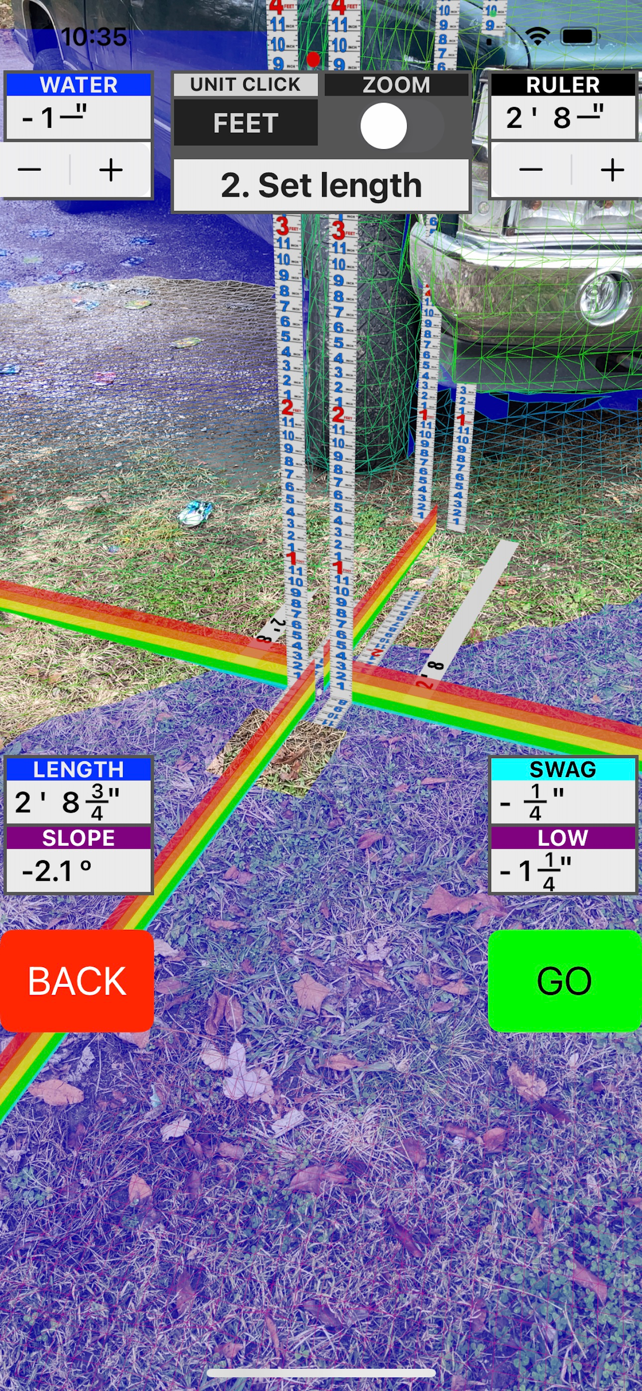
This level makes so much since once you get it. After that you will go for this first!

Store-Rankings

Ranking-Verlauf
App-Ranking-Verlauf noch nicht verfügbar
Kategorien-Rankings
App ist noch nicht gerankt

Precision Transit Level mini-X Konkurrenten

Name
Measure Angles Pro Level Tool
Protractor, Clinometer, Bubble
Shipping Work Calculator
Labor saving in boxing work!
4K5 LightControl
Remote control for flashlights
U-Level
Mohr's Circle
Calculation and Drawing
Title Check
For double registered songs
Division Calculator
Show Division Step by Step
Laser Level 2023
All-in-one level app
Easy Cons
Easy Construction
Zero calculator

Precision Transit Level mini-X Installationen

Letzte 30 Tage

Precision Transit Level mini-X Umsatz

Letzte 30 Tage

Precision Transit Level mini-X Einnahmen und Downloads

Gewinnen Sie wertvolle Einblicke in die Leistung von Precision Transit Level mini-X mit unserer Analytik.
Melden Sie sich jetzt an, um Zugriff auf Downloads, Einnahmen und mehr zu erhalten.