Relief Maps: Hike, Ski, Climb

Explore the backcountry in 3D

Veröffentlicht von: Batiste Vonderweidt

Beschreibung

Relief Maps is your ultimate guide to all your mountain adventures.
Whether you're hiking, skiing, trekking, paragliding or even mountaineering, our 3D map makes it easy to find your way.
See the USGS maps as you've never seen it before in 3D!

Hiking to an area with no internet connection? No problem! Our gps app offers offline maps so you can continue your navigation even without a network. You can download USGS maps and use them in offline mode, so you'll always be sure of your position and direction.

Hiking :
Find hikes nearby, our route catalog will help you find interesting trails all around you, whether you just want to go for a stroll or a sporty hike.
Our route planning system also lets you easily plot your own routes, then export them to GPX.

Mountaineering :
Consult camp-to-camp and skitour topos with GPS tracks and easily find the start of your dream route! From Mont Blanc to Aiguille Verte via the whymper couloir, climb every peak in the Alps!
Enjoy the best 3D visualization available on Chamonix and the French Alps.
Climbing:
Stop searching for hours for the start of a route! Find the start of a route with the GPX tracks available in the app.

Trek :
A trek lasting several days? You can plan your adventure easily with Relief Maps.
Find a list of points of interest that will help you, refuges, free parking lots, water points, toilets, campsites & bivouacs etc.
Find the best paths on our topo and IGN maps, and calculate the distance, altitude difference and duration of your route easily.
Whether you're trekking on the PCT or on the Appalachian Trail Relief Maps goes everywhere with you!

Ski touring :
Explore the mountains on skis with our ski touring tools.
Analyze the terrain with augmented reality or 3D slope maps.
Take advantage of detailed weather forecasts with snowfall, temperatures by altitude, etc.
Consult skitour and camp-to-camp topos all over France and Europe.
Enjoy the best 3D visualization available on Chamonix and the French Alps.

Paragliding :
Used by many Xalps athletes, the app offers you all the tools you need for paragliding:
- Precise paragliding weather, wind, thermals, etc.
- Map of the best-known thermals
- Glide ratio calculator
- Live tracking
- Track replay

Downhill skiing:
- Find the piste maps of major resorts such as Park City, Breckenridge, Jackson Hole and many others.

Free features :
- 3D map consultation
- Route planning
- Nearby routes
- Hiking, walking, mountaineering, climbing, ski touring, mountain skiing, walking and paragliding routes
- Points of interest (refuges, water points, free parking, etc.)
- Track recording
- GPX track replay
- Track synchronization with Suunto watch
- Augmented reality
- Glide calculation (paragliding)
Premium :
- Off-line maps
- Livetracking
- IGN map
- Weather forecasts
- Route saving/tracking
- Slope maps (for avalanche risk in ski touring)
- Winter map
- USGS Maps
- GPX import/export
Maps:
- USGS topo
- USGS satellite
- 3D terrain
- IGN free map
- IGN scan
- IGN satellite
- Avalanche slope
- Satellite
- Swisstopo
- Swisstopo satellite
- osm summer
- osm winter
--
Premium subscription : 29.99€/an
Terms of use: https://reliefmaps.io/terms.html
Privacy policy: https://reliefmaps.io/privacy.html
Ausblenden Mehr anzeigen...

In-App-Käufe

IGN Yearly
62.99 zł
Premium Yearly
47.99 zł
Premium Monthly
3.99 zł
Premium Lifetime
129.99 zł

Screenshots

Relief Maps Häufige Fragen

  • Ist Relief Maps kostenlos?

    Ja, Relief Maps ist kostenlos herunterzuladen, enthält jedoch In-App-Käufe oder Abonnements.

  • Ist Relief Maps seriös?

    🤔 Die Qualität der Relief Maps-App ist gemischt. Einige Nutzer sind zufrieden, während andere Probleme melden. Ziehen Sie in Betracht, einzelne Bewertungen für mehr Kontext zu lesen.

    Danke für die Stimme

  • Wie viel kostet Relief Maps?

    Relief Maps bietet mehrere In-App-Käufe/Abonnements, der durchschnittliche In-App-Preis beträgt 61.24 zł.

  • Wie hoch ist der Umsatz von Relief Maps?

    Um geschätzte Einnahmen der Relief Maps-App und weitere AppStore-Einblicke zu erhalten, können Sie sich bei der AppTail Mobile Analytics Platform anmelden.

Benutzerbewertung

4.55 von 5

11 Bewertungen in Polen

5 star
9
4 star
1
3 star
0
2 star
0
1 star
1
Bewertungsverlauf

Relief Maps Bewertungen

Top

Jukurrpa on

Frankreich

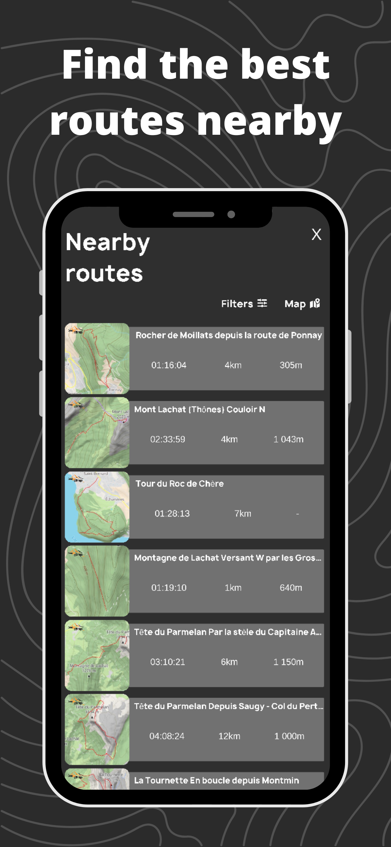
Ne remplace pas FATMAP mais reste une super application pour la rando Freeride

Génial !

Vreesse on

Frankreich

Pour la pratique du parapente en marche et vol c’est juste génial ! Pour visualiser la finesse et la marche d’approche parfait même en version gratuite ! Merci

Problème d’affichage global sur iPhone 16 Pro

Tomiwalki on

Frankreich

Ancien utilisateur de Fatmap, je découvre cette alternative. Hélas c’est la douche froide dès la première utilisation sur iPhone 16 Pro (6.3"). En effet il y a une problème d’affichage globale : la fonction « Burger » en haut à gauche pour ouvrir le menu vertical est rogné, donc c’est difficile à activer. De plus le menu vertical gauche s’affiche dans une résolution trop petite, c’est à peine lisible, donc l’expérience utilisateur est vraiment pas top. Possible de corriger ? Merci !

Better than FatMap…

Lolithaaaaaaaaaaaaa on

Frankreich

…e o CEO é um gostoso

Mon avis

Moroges on

Frankreich

Cartes extrêmement détaillées et précises Design excellent Bravo !

Rapide pour programmer un itinéraire

thomasd74 on

Frankreich

Rapide et efficace pour planifier une sortie. Dommage que le GPS continue en arrière plan (consomme beaucoup de batterie) : il faut fermer l’application. Et dommage qu’on ne puisse pas ouvrir sur la carte IGN directement.

Timlyn

Bulli concept on

Frankreich

Super application mais… toutes les rubriques ou pictogrammes sont trop petites et quasi impossibles à lire en pleine activité !!

Perfect outdoors activities app

Polygolof on

Frankreich

Just the best one Works perfectly my iPhone

Mon application préférée

Mouchetteht on

Frankreich

Je l’utilise depuis un an. Je la trouvais top mais avec un petit bémol car le téléchargement des cartes pouvait planter. Mais depuis la nouvelle mise à jour c’est parfait. En plus le rajout des pourcentages de pentes c’est top pour le ski. Merci

App très prometteuse

Jiyuu42 on

Frankreich

Je viens de découvrir cette app et elle semble vraiment bien. Est-il nécessaire de reprendre un abonnement IGN pour ces cartes si on a déjà un abonnement existant ? Pour être parfaite, il manquerait quelques fonctionnalités, comme : - stats de km, d+, temps... (peut être avec la version premium ? Je me tâte à la prendre) - synchro directe avec les montres garmin - avoir la possibilité d’afficher des indicateurs tous les km, ou 2, 5... km sur une trace - fusion de trace - ... Quelques fonctionnalités qui me feraient quitter Relive (je n’utilise pas STRAVA 😁) Bravo au dev. C’est dans tous les cas du beau boulot.

Store-Rankings

Ranking-Verlauf
Kategorien-Rankings
Diagramm
Kategorie
Rang
Top Umsatz
12
Top Umsatz
17
Top Umsatz
21
Top Umsatz
23
Top Umsatz
28

Relief Maps Konkurrenten

Relief Maps Installationen

Letzte 30 Tage

Relief Maps Umsatz

Letzte 30 Tage

Relief Maps Einnahmen und Downloads

Gewinnen Sie wertvolle Einblicke in die Leistung von Relief Maps mit unserer Analytik.
Melden Sie sich jetzt an, um Zugriff auf Downloads, Einnahmen und mehr zu erhalten.
This page includes copyrighted content from third parties, shared solely for commentary and research in accordance with fair use under applicable copyright laws. All trademarks, including product, service, and company names or logos, remain the property of their respective owners. Their use here falls under nominative fair use as outlined by trademark laws and does not suggest any affiliation with or endorsement by the trademark holders.