
Beschreibung
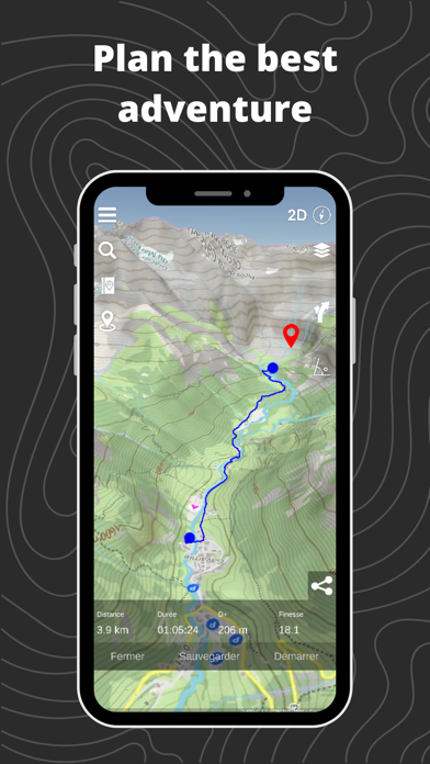
Whether you're hiking, skiing, trekking, paragliding or even mountaineering, our 3D map makes it easy to find your way.
See the USGS maps as you've never seen it before in 3D!
Hiking to an area with no internet connection? No problem! Our gps app offers offline maps so you can continue your navigation even without a network. You can download USGS maps and use them in offline mode, so you'll always be sure of your position and direction.
Hiking :
Find hikes nearby, our route catalog will help you find interesting trails all around you, whether you just want to go for a stroll or a sporty hike.
Our route planning system also lets you easily plot your own routes, then export them to GPX.
Mountaineering :
Consult camp-to-camp and skitour topos with GPS tracks and easily find the start of your dream route! From Mont Blanc to Aiguille Verte via the whymper couloir, climb every peak in the Alps!
Enjoy the best 3D visualization available on Chamonix and the French Alps.
Climbing:
Stop searching for hours for the start of a route! Find the start of a route with the GPX tracks available in the app.
Trek :
A trek lasting several days? You can plan your adventure easily with Relief Maps.
Find a list of points of interest that will help you, refuges, free parking lots, water points, toilets, campsites & bivouacs etc.
Find the best paths on our topo and IGN maps, and calculate the distance, altitude difference and duration of your route easily.
Whether you're trekking on the PCT or on the Appalachian Trail Relief Maps goes everywhere with you!
Ski touring :
Explore the mountains on skis with our ski touring tools.
Analyze the terrain with augmented reality or 3D slope maps.
Take advantage of detailed weather forecasts with snowfall, temperatures by altitude, etc.
Consult skitour and camp-to-camp topos all over France and Europe.
Enjoy the best 3D visualization available on Chamonix and the French Alps.
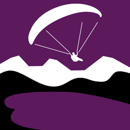
Paragliding :
Used by many Xalps athletes, the app offers you all the tools you need for paragliding:
- Precise paragliding weather, wind, thermals, etc.
- Map of the best-known thermals
- Glide ratio calculator
- Live tracking
- Track replay
Downhill skiing:
- Find the piste maps of major resorts such as Park City, Breckenridge, Jackson Hole and many others.
Free features :
- 3D map consultation
- Route planning
- Nearby routes
- Hiking, walking, mountaineering, climbing, ski touring, mountain skiing, walking and paragliding routes
- Points of interest (refuges, water points, free parking, etc.)
- Track recording
- GPX track replay
- Track synchronization with Suunto watch
- Augmented reality
- Glide calculation (paragliding)
Premium :
- Off-line maps
- Livetracking
- IGN map
- Weather forecasts
- Route saving/tracking
- Slope maps (for avalanche risk in ski touring)
- Winter map
- USGS Maps
- GPX import/export
Maps:
- USGS topo
- USGS satellite
- 3D terrain
- IGN free map
- IGN scan
- IGN satellite
- Avalanche slope
- Satellite
- Swisstopo
- Swisstopo satellite
- osm summer
- osm winter
--
Premium subscription : 29.99€/an
Terms of use: https://reliefmaps.io/terms.html
Privacy policy: https://reliefmaps.io/privacy.html
In-App-Käufe
- USGS Monthly
- 3.90 R$
- Premium Yearly
- 99.90 R$
- Premium Monthly
- 3.90 R$
Screenshots


Relief Maps Häufige Fragen
-
Ist Relief Maps kostenlos?
Ja, Relief Maps ist kostenlos herunterzuladen, enthält jedoch In-App-Käufe oder Abonnements.
-
Ist Relief Maps seriös?
Nicht genügend Bewertungen, um eine zuverlässige Einschätzung vorzunehmen. Die App benötigt mehr Nutzerfeedback.
Danke für die Stimme -
Wie viel kostet Relief Maps?
Relief Maps bietet mehrere In-App-Käufe/Abonnements, der durchschnittliche In-App-Preis beträgt 35.90 R$.
-
Wie hoch ist der Umsatz von Relief Maps?
Um geschätzte Einnahmen der Relief Maps-App und weitere AppStore-Einblicke zu erhalten, können Sie sich bei der AppTail Mobile Analytics Platform anmelden.

4.83 von 5
12 Bewertungen in Brasilien
Relief Maps Bewertungen
Store-Rankings
|
Diagramm
|
Kategorie
|
Rang
|
|---|---|---|
|
Top Umsatz
|

|
17
|
|
Top Umsatz
|

|
17
|
|
Top Umsatz
|

|
19
|
|
Top Umsatz
|

|
24
|
|
Top Umsatz
|

|
27
|
Schlüsselwörter
Relief Maps Konkurrenten
| Name | Downloads (30d) | Monatlicher Umsatz | Rezensionen | Bewertungen | Letzte Veröffentlichung | |
|---|---|---|---|---|---|---|

Iphigénie | The Hiking Map App
IGN maps, hiking, outdoor
|
View
|
View
|
0
|
|
vor 2 Wochen | |
OutDoors GPS France - IGN Maps
Plan Hiking & Biking Routes
|
View
|
View
|
0
|
|
vor 1 Jahr | |

IGNrando' – France hiking maps
Hiking & cycling with IGN maps
|
View
|
View
|
0
|
|
vor 1 Tag | |

SDVFR
|
View
|
View
|
0
|
|
vor 2 Monaten | |

SeeYou Navigator
|
View
|
View
|
2
|
|
vor 2 Wochen | |

ESF Carnet Rouge
Les ESF et la montagne
|
View
|
View
|
0
|
|
vor 4 Monaten | |

3D Mapas Offline: GPS tracker
Navegador e rotas, pedômetro
|
View
|
View
|
2
|
|
vor 2 Monaten | |
where2fly paragliding
|
View
|
View
|
0
|
|
vor 1 Jahr | |

Vario One
Variometer with sound output
|
View
|
View
|
0
|
|
vor 1 Monat | |

RealityMaps 3D Tourenplaner
|
View
|
View
|
0
|
|
vor 1 Jahr |
Relief Maps Installationen
Letzte 30 Tage
Relief Maps Umsatz
Letzte 30 TageRelief Maps Einnahmen und Downloads
Melden Sie sich jetzt an, um Zugriff auf Downloads, Einnahmen und mehr zu erhalten.
App-Informationen
- Kategorie
- Navigation
- Herausgeber
- Batiste Vonderweidt
- Sprachen
- English, French
- Letzte Veröffentlichung
- 2.2.2 (vor 1 Monat )
- Veröffentlicht am
- Jan 20, 2019 (vor 5 Jahren )
- Auch verfügbar in
- Frankreich, Vereinigte Staaten, Schweiz, Italien, Indonesien, Türkei, Deutschland, Spanien, Österreich, Vereinigtes Königreich, Belgien, Russland, Brasilien, Indien, Polen, Kanada, Mexiko, Malaysia, Niederlande, Slowenien, Thailand, Rumänien, Ukraine, Vietnam, Südkorea, Slowakei, Tschechien, China, Kroatien, Chile, Bulgarien, Australien, Algerien, Philippinen, Portugal, Kolumbien, Argentinien, Pakistan, Kasachstan, Nepal, Saudi-Arabien, Vereinigte Arabische Emirate, Schweden, Griechenland, Estland, Tunesien, Taiwan, Island, Singapur, Ungarn, Luxemburg, Lettland, Finnland, Dominikanische Republik, Norwegen, Neuseeland, Usbekistan, Südafrika, Irland, Armenien, Aserbaidschan, Bahrain, Brunei Darussalam, Belarus, Zypern, Dänemark, Ecuador, Ägypten, Sonderverwaltungsregion Hongkong, Peru, Israel, Japan, Kuwait, Libanon, Litauen, Madagaskar, Nordmazedonien, Malta, Nigeria
- Zuletzt aktualisiert
- vor 2 Wochen
- © 2025 AppTail.
- Unterstützung
- Privacy
- Terms
- All Apps