Français
Cela pourrait être vraiment bien si il y’avait possibilité de mettre en français.


Ja, Rother ist kostenlos herunterzuladen, enthält jedoch In-App-Käufe oder Abonnements.
⚠️ Die Rother-App hat schlechte Bewertungen und negatives Feedback. Die Nutzer scheinen mit der Leistung oder den Funktionen unzufrieden zu sein.
Rother bietet mehrere In-App-Käufe/Abonnements, der durchschnittliche In-App-Preis beträgt €17.99.
Um geschätzte Einnahmen der Rother-App und weitere AppStore-Einblicke zu erhalten, können Sie sich bei der AppTail Mobile Analytics Platform anmelden.

2.6 von 5
10 Bewertungen in Frankreich
Cela pourrait être vraiment bien si il y’avait possibilité de mettre en français.
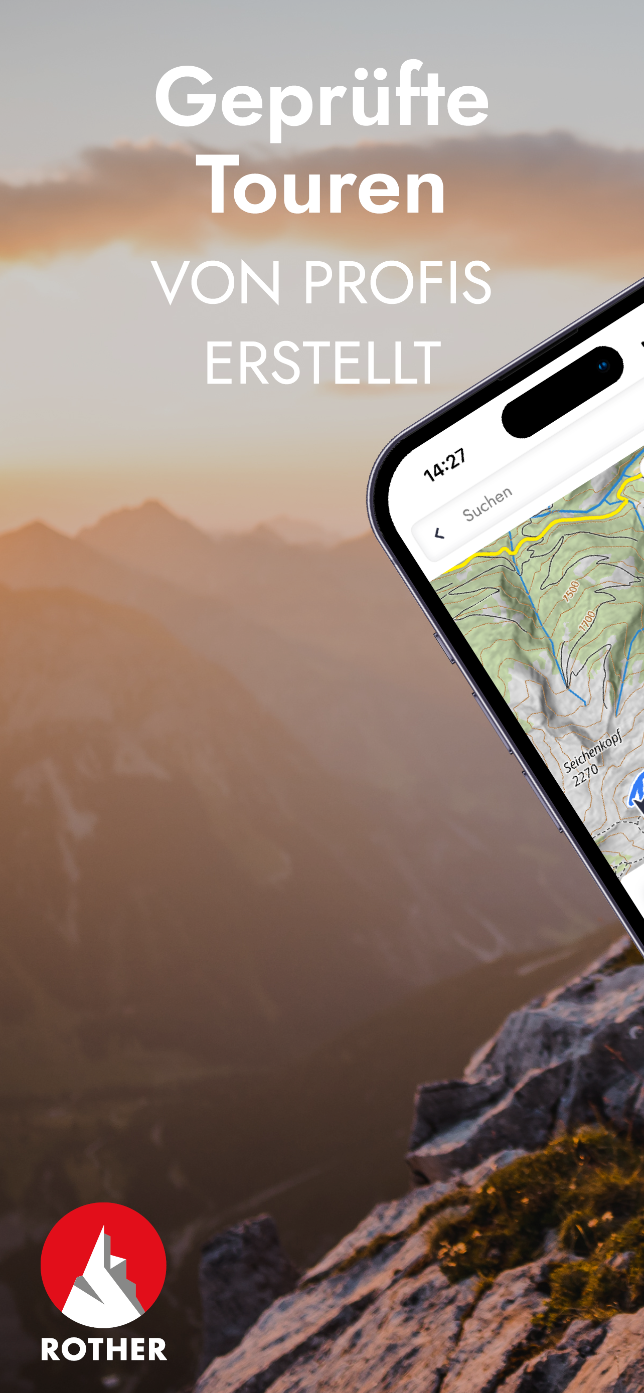
Karte zeigt ca. 10 Touren am Standort, app findet keine einzige
Aucun contenu disponible a part en Europe.
It's a pity the application is not translated (English, French). Is it possible to get GPS traces using the code from books ?
Very good application eager the english or better french version of the guides
Leider schafft es Rother trotz meiner Bitte nicht, die Skitourenführer mit in die App einzubinden. Angeblich fehlende Digitalisierung, was, wenn es stimmt, ein Armutszeugnis ist, oder, wenn es nicht stimmt, einfach nur blöde Geldschneiderrei ist. Ferner ist die Sortierung bei Streckenwanderungen ohne System. Ich habe die Peaks of the Balkan Tour geplant. Das sind 10 Tage Strecke, aber die Tage werden in der App nich hintereinander angezeigt. Ferner haben die Tage teilweise eine unterschiedliche Richtung. Alles nicht schlimm, aber so unnötig. Wenn ein Führer schon Peaks of the Balkan heißt, sollte die gleichnamige Streckenwanderung systematisch angezeigt werden.
leider funktioniert der GPX-Export über die App nicht.
Also Leute, die Karte ist echt super, habe den Stubaier Höhenweg mit dem Führer und der Karte gemacht, aber die Navigation innerhalb der App ist echt gewöhnungsbedürftig. Warum sehe ich denn dauernd so eine Kamera mit kleinen Leuten drauf? Ich bin doch kein Kind mehr. Das ist doch verschenkter Platz. Man kann die einzelnen Touren nicht sortieren etc. Aber das Hauptproblem ist, dass sich die Karte offenbar nur bei Internetempfang einnordet. Jetzt stehe ich in den Hochalpen und lege einen Kompass auf mein Handy und drehe das Teil, bis die Karte ausgerichtet ist? Habt ihr keinen Zugang zum Kompass des Telefonherstellers gekauft und selbst etwas gebastelt? Das kann ja sogar komoot. Das war doch sehr enttäuschend. Da mach ich wohl nächstes Jahr den GR 20 doch mit einer Alternative? Oder habe ich irgendwo die Nutzung des GPS verweigert? So jedenfalls nicht nutzbar. Sogar gefährlich, weil die Karte in irgendeiner Richtung einfriert…
Laut App-Beschreibung sollen In-App-Käufe für einzelne Regionen möglich sein. Mich hätte zum Beispiel Korsika für EUR 14,99 interessiert. Die App hingegen bietet mir überhaupt nicht die Möglichkeit für diesen In-App-Kauf, vielmehr soll ich über ein Probeabo unklaren Zeitraums (nach langem Suchen habe ich festgestellt, dass es sich wohl um nur 7 Tage handelt) in eine doppelt so teure Abofalle (nicht einmalig sondern jährlich anfallend) gedrängt werden… Rother behauptet jetzt in einer Stellungnahme (23.07.2024), ich könne in der App unter Guides den gewünschten Guide suchen und einzeln kaufen. Genau das habe ich aber versucht und der einzelne Führer wird mir dort eben nicht zum Kauf angeboten. Es bleibt also bei meinem Urteil!
Ich dachte man könnte gekaufte Führer registrieren und hätte dann Zugang zu den Tracks. Das ist (obwohl es in und auf manchen Führern so beworben wird) nicht möglich. Man kann scheinbar GPX Tracks importieren und dann mit den (freien) openstreetmap Karten verwenden. Das können auch viele andere Apps die nicht nebenbei immer online führer verkaufen wollen (für die man schon als Print bezahlt hat).
|
Diagramm
|
Kategorie
|
Rang
|
|---|---|---|
|
Top Umsatz
|

|
11
|
|
Top Umsatz
|

|
12
|
|
Top Umsatz
|

|
16
|
|
Top Umsatz
|

|
18
|
|
Top Umsatz
|

|
20
|
| Name | Rezensionen | Bewertungen | Letzte Veröffentlichung | |
|---|---|---|---|---|
Rhénanie-Palatinat tourisme
|
0
|
|
vor 10 Monaten | |

Registre de sommet
SummitLynx
|
1
|
|
vor 2 Jahren | |

bergfex: randonnee & tracking
Planifier & naviguer avec GPS
|
6
|
|
vor 1 Woche | |

alpenvereinaktiv
Tourenportal der Alpenvereine
|
0
|
|
vor 1 Tag | |

MARCO POLO Discovery Tours
|
0
|
|
vor 3 Monaten | |

KOMPASS Outdoor & Hiking Maps
|
5
|
|
vor 1 Monat | |

CAS – Club Alpin Suisse
Courses, cabanes et bien plus
|
1
|
|
vor 5 Monaten | |

mmTravel guide tour planner
city map tracks hike gpx gps
|
0
|
|
vor 3 Tagen | |

South Tyrol/Südtirol Guide
|
0
|
|
vor 1 Jahr | |

Camino Love:Camino de Santiago
Chemin St. Jacques | Auberges
|
0
|
|
vor 2 Tagen |
