My scans are bad - any tip?
I tired this app often but I always experience drift and misalignments in the mesh Any tip? The video here looks so brilliant


Ja, RTAB-Map ist komplett kostenlos und enthält keine In-App-Käufe oder Abonnements.
Nicht genügend Bewertungen, um eine zuverlässige Einschätzung vorzunehmen. Die App benötigt mehr Nutzerfeedback.
RTAB-Map ist kostenlos.
Um geschätzte Einnahmen der RTAB-Map-App und weitere AppStore-Einblicke zu erhalten, können Sie sich bei der AppTail Mobile Analytics Platform anmelden.

5 von 5
3 Bewertungen in Finnland
I tired this app often but I always experience drift and misalignments in the mesh Any tip? The video here looks so brilliant
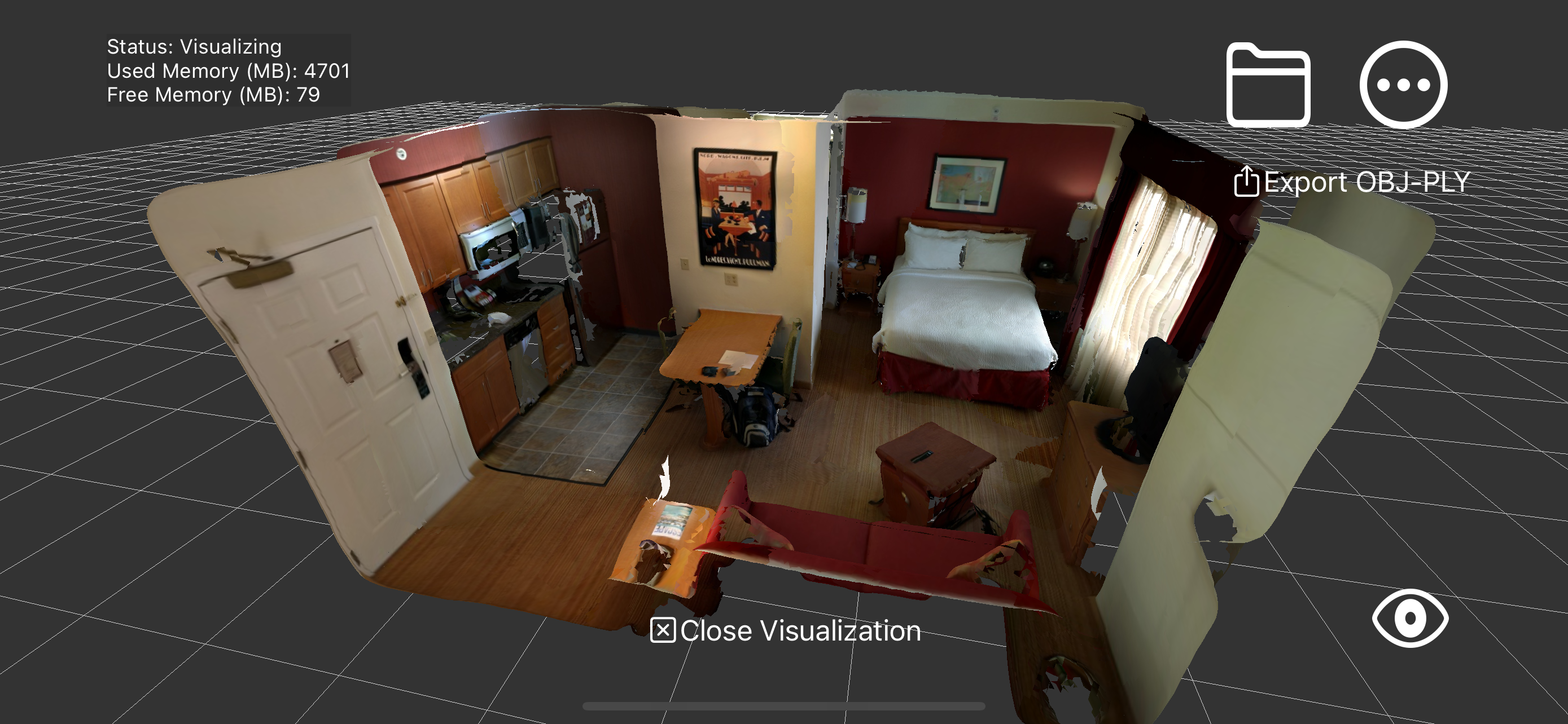
If you’re looking for a 3d scanner app, stop here! You’ve found it. I would give this 6 stars if I could. RTAB-Map is fabulous. It does the job and gets out of the way. No ads, no accounts, no spyware. You open it and it just works. Simple data formats, easy sharing. What a refreshingly straightforward tool—thank you Mathieu!
Exactly what I’ve been looking for…almost. I’m a land surveyor and have been waiting for a self correcting scan app. If able, please provide colorized point cloud export option. This app could prove extremely helpful with that option.
There is no better 3D scanning app for the real 3D scan enthusiast. I have tried all 20 or so of them, with full feature unlocks. The only downside is that big scans need lots of RAM, so go ahead and get yourself a tablet with at least 16GB of RAM. otherwise, it will be unstable and keep closing on you without saving. I’ve had a lot of great scans get lost. But the scans that didn’t get erased are insane. Loop closure is so crazy.
| Name | Rezensionen | Bewertungen | Letzte Veröffentlichung | |
|---|---|---|---|---|

Canvas: LiDAR 3D Measurements
Fast, Easy As-Built CAD/BIM
|
0
|
|
vor 1 Woche | |

Canvas Lite for Homeowners
Remote 3D Home Measurement
|
0
|
|
vor 7 Monaten | |

SiteScape: LiDAR Scanner & CAD
3D Scan, 3D Model, 3D Photo
|
0
|
|
vor 4 Monaten | |

PIX4Dcatch: 3D scanner
3D models from images & LiDAR
|
0
|
|
vor 5 Stunden | |

Revo Scan-3D scanner app
3D Scan APP
|
2
|
|
vor 3 Wochen | |

Quantum Summer
Lidar Scan and Share 3D Spaces
|
0
|
|
vor 3 Jahren | |

Recon-3D
Accurate 3D Data For Forensics
|
1
|
|
vor 3 Monaten | |

LiDAR Pointer
Distance measuring tool
|
0
|
|
vor 2 Jahren | |

Lidar Scanner
3D Room and Pose Point Cloud
|
0
|
|
vor 2 Jahren | |

3D LiDAR Scanner
Depth Capture & 3D Export
|
0
|
|
vor 2 Jahren |
