Beschreibung
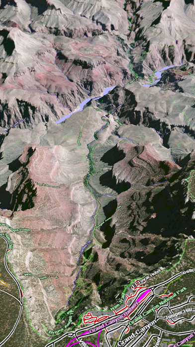
Online satellite image overlays add breathtaking detail and realism to the maps (tap preset 2 or 4 when Online Map is enabled). You can use them as you travel to see what is hidden from view at ground level. This takes moving maps to a whole new level. With an in-app purchase you can expand the coverage to the entire world via the Scenic Map online map and cache the data for offline use.
Use the two finger vertical swipe gesture to tilt the map for a 3D view. Scroll like a map or fly like a flight simulator. Enable Joystick Gestures in the Settings menu and then fly around the terrain using a virtual joystick. Prefer only 2D maps? Enable the 2D Map option in the Settings menu.
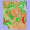
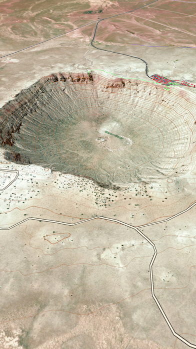
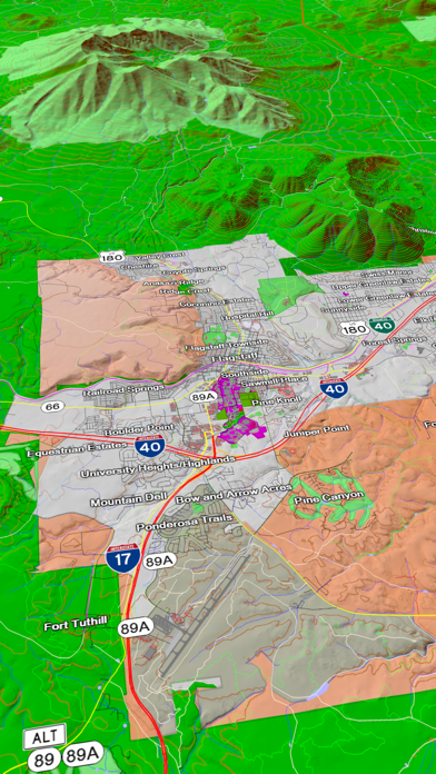
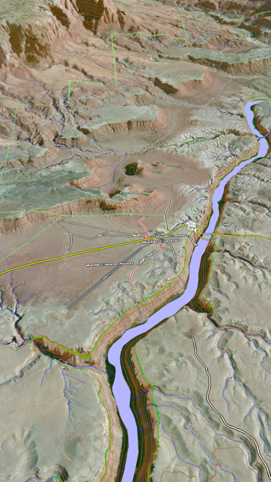
Scenic Map is simply the best 3D topo map available for a mobile device. You will see incredible detail while scrolling, rotating and zooming perfectly smoothly. You will see every road even if you zoom out to the altitude of a satellite. As you zoom in, you will see every small bump and hollow of the Earth and terrain features as small as ten meters. Unlike old fashioned topo maps, Scenic Map’s roads and trails are up to date thanks to OpenStreetMap.org. It contains polygons for urban areas, shopping malls, an ever growing number of buildings and many other features, The best lake, pond, stream and rivers from the USGS and Canadian public databases are also included.
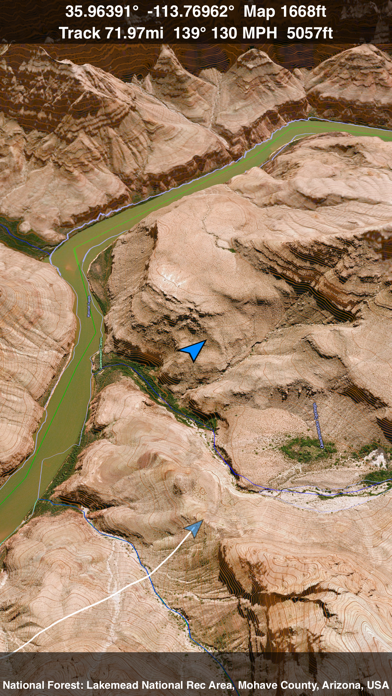
Tap the GPS center button to begin tracking your location. As you move, you will generate a track file. Tracks can be replayed with video like controls to speed up, slow down, pause, restart or skip to the end. You can display existing tracks while recording another if you want to retrace your route. When online, you can automatically create a route from your current GPS location to any other point on the map. Tracks can be received from or sent to other apps in GPX format. GPS recording stops automatically after you have remained stationary for some time or you can choose to manually stop tracking by tapping on the top track in the Tracks view.
Never before have maps been this customizable. For example, you can turn on or off the roads. You can change the lighting direction or remove terrain shading entirely. You can display contour lines even over satellite images. There are five presets which let you quickly switch between map styles. Use Metric, English or Nautical units and choose one of four different coordinate displays including UTM.
Want to learn more about a map feature? Tap the target icon and center the feature under the compass rose to display its name, type, urban area, county, state, elevation and coordinates. You will also see a bearing line back to your current GPS location or from your location to a selected waypoint. The status bar shows the bearing direction and distance along with the map and GPS elevation, the track length, and your current speed and direction of travel.
In-app documentation is provided in the Help section at the top of the Settings menu. Links are provided in the documentation to detailed coverage maps, tutorial videos, installation guide and blog at ScenicMap.com
Map data © OpenStreetMap and contributors under the Open Database License
Scenic Map supports GPS tracking while the app is in the background.
Caution: Continued use of GPS running in the background can dramatically decrease battery life.
Screenshots
Scenic Map Grand Canyon Häufige Fragen
-
Ist Scenic Map Grand Canyon kostenlos?
Ja, Scenic Map Grand Canyon ist komplett kostenlos und enthält keine In-App-Käufe oder Abonnements.
-
Ist Scenic Map Grand Canyon seriös?
Nicht genügend Bewertungen, um eine zuverlässige Einschätzung vorzunehmen. Die App benötigt mehr Nutzerfeedback.
Danke für die Stimme -
Wie viel kostet Scenic Map Grand Canyon?
Scenic Map Grand Canyon ist kostenlos.
-
Wie hoch ist der Umsatz von Scenic Map Grand Canyon?
Um geschätzte Einnahmen der Scenic Map Grand Canyon-App und weitere AppStore-Einblicke zu erhalten, können Sie sich bei der AppTail Mobile Analytics Platform anmelden.

2 von 5
1 Bewertungen in Malaysia
Scenic Map Grand Canyon Bewertungen
Store-Rankings
|
Diagramm
|
Kategorie
|
Rang
|
|---|---|---|
|
Top Kostenlos
|

|
387
|
|
Top Kostenlos
|

|
408
|
|
Top Kostenlos
|

|
486
|
Scenic Map Grand Canyon Konkurrenten
| Name | Downloads (30d) | Monatlicher Umsatz | Rezensionen | Bewertungen | Letzte Veröffentlichung | |
|---|---|---|---|---|---|---|

Military GPS Survival Kit
MGRS SAR Tactical Navigation
|
Freischalten
|
Freischalten
|
0
|
1
|
vor 3 Wochen | |

Topo Maps US
|
Freischalten
|
Freischalten
|
0
|
|
vor 3 Monaten | |

3D maps offline: Gps tracker
Navigation,hiking trails, gpx
|
Freischalten
|
Freischalten
|
0
|
|
vor 16 Stunden | |

Topo Nomad
USGS Topographical Maps
|
Freischalten
|
Freischalten
|
0
|
|
vor 1 Jahr | |

Route3D 3.0
Topo map navigation
|
Freischalten
|
Freischalten
|
0
|
|
vor 2 Jahren | |

Topo Reader
USGS Topographical Maps
|
Freischalten
|
Freischalten
|
0
|
|
vor 1 Jahr | |

Grand Canyon NP Audio Guide
Grand Canyon South Rim Tours
|
Freischalten
|
Freischalten
|
0
|
|
vor 6 Tagen | |

Explore Sedona & Northern AZ
|
Freischalten
|
Freischalten
|
0
|
|
vor 2 Jahren | |

OkMap Mobile
An off road GPS navigator
|
Freischalten
|
Freischalten
|
0
|
|
vor 1 Monat | |

Zion & Bryce Canyon Utah Guide
Utah National Park Audio Guide
|
Freischalten
|
Freischalten
|
0
|
|
vor 2 Wochen |
Scenic Map Grand Canyon Installationen
Letzte 30 Tage
Scenic Map Grand Canyon Umsatz
Letzte 30 TageScenic Map Grand Canyon Einnahmen und Downloads
Melden Sie sich jetzt an, um Zugriff auf Downloads, Einnahmen und mehr zu erhalten.
App-Informationen
- Kategorie
- Navigation
- Herausgeber
- GrangerFX
- Sprachen
- English
- Letzte Veröffentlichung
- 1.9.2 (vor 8 Monaten )
- Veröffentlicht am
- Apr 1, 2010 (vor 14 Jahren )
- Auch verfügbar in
- Türkei, Singapur, Spanien, Japan, Russland, Deutschland, Saudi-Arabien, Vereinigtes Königreich, Irland, Schweden, Italien, Südkorea, Dänemark, Tschechien, China, Portugal, Vereinigte Staaten, Brasilien, Argentinien, Rumänien, Malaysia, Nigeria, Niederlande, Norwegen, Neuseeland, Thailand, Polen, Taiwan, Österreich, Australien, Vereinigte Arabische Emirate, Belgien, Vietnam, Kanada, Schweiz, Chile, Kolumbien, Dominikanische Republik, Algerien, Ägypten, Finnland, Frankreich, Ungarn, Ukraine, Südafrika, Pakistan, Philippinen, Peru, Mexiko, Libanon, Kasachstan, Kuwait, Indien, Israel, Indonesien, Sonderverwaltungsregion Hongkong, Griechenland, Ecuador, Belarus, Bulgarien, Aserbaidschan
- Zuletzt aktualisiert
- vor 1 Tag
- © 2024 AppTail.
- Unterstützung
- Privacy
- Terms
- All Apps