Singapore MRT Map Route

Subway, Metro Transport

Veröffentlicht von: Wan Peng

Beschreibung

Updated Thomson-East Coast Line (TE1 Woodlands North to Orchard) to the subway system
Singapore's MRT system is extending. By 2030, the MRT system will be more complex than you could image. It's good for all residents on our lovely island. But also will be a problem because we don't know how to travel the fastest when transfering stations.
Singapore MRT Map Route is designed to allows user to get the best route within a second. It will help you save a lot of time over years.
- View lastest Singapore MRT map
- Display the best route between two stations
- Automatically calculate estimated travel time
- Require no internet connection.
Updated to latest MRT system:
Downtown Line(Blue)
Bukit Panjang, Cashew, Hillview, Beauty World, King Albert Park, Sixth Avenue, Tan Kah Kee, Botanic Gardens, Stevens, Newton, Little India, Rochor, Bugis, Promenade, Bayfront, Downtown, Telok Ayer, Chinatown
Circle Line(Yellow)
Dhoby Ghaut, Bras Basah, Esplanade, Promenade, Nicoll Highway[C], Stadium, Mountbatten, Dakota, Paya Lebar, MacPherson, Tai Seng, Bartley, Serangoon, Lorong Chuan, Bishan, Marymount, Caldecott, Botanic Gardens, Farrer Road, Holland Village. Buona Vista, one-north, Kent Ridge, Haw Par Villa, Pasir Panjang, Labrador Park, Telok Blangah, HarbourFront
East West Line (Green)
Pasir Ris ,Tampines , Simei , Tanah Merah , Bedok , Kembangan , Eunos , Paya Lebar , Aljunied , Kallang , Lavender , Bugis , City Hall , Raffles Place , Tanjong Pagar , Outram Park , Tiong Bahru , Redhill , Queenstown , Commonwealth , Buona Vista , Dover ,Clementi , Jurong East , Chinese Garden , Lakeside , Boon Lay , Pioneer , Joo Koon, Expo,
Changi Airport
North South Line (Red)
Jurong East, Bukit Batok, Bukit Gombak, Choa Chu Kang, Yew Tee, Kranji, Marsiling, Woodlands, Admiralty, Sembawang, Canberra, Yishun, Khatib, Yio Chu Kang, Ang Mo Kio, Bishan, Braddell, Toa Payoh, Novena, Newton, Orchard, Somerset, Dhoby Ghaut, City Hall, Raffles Place, Marina Bay, Marina South Pier
North East Line (Purple)
HarbourFront, Outram Park, Chinatown, Clarke Quay, Dhoby Ghaut, Little India, Farrer Park, Boon Keng, Potong Pasir, Woodleigh, Serangoon, Kovan, Hougang, Buangkok, Sengkang, Punggol
Ausblenden Mehr anzeigen...

In-App-Käufe

Full Version
£0.99
Support Developer
£0.99

Screenshots

Singapore MRT Map Route Häufige Fragen

  • Ist Singapore MRT Map Route kostenlos?

    Ja, Singapore MRT Map Route ist kostenlos herunterzuladen, enthält jedoch In-App-Käufe oder Abonnements.

  • Ist Singapore MRT Map Route seriös?

    🤔 Die Qualität der Singapore MRT Map Route-App ist gemischt. Einige Nutzer sind zufrieden, während andere Probleme melden. Ziehen Sie in Betracht, einzelne Bewertungen für mehr Kontext zu lesen.

    Danke für die Stimme

  • Wie viel kostet Singapore MRT Map Route?

    Singapore MRT Map Route bietet mehrere In-App-Käufe/Abonnements, der durchschnittliche In-App-Preis beträgt £0.99.

  • Wie hoch ist der Umsatz von Singapore MRT Map Route?

    Um geschätzte Einnahmen der Singapore MRT Map Route-App und weitere AppStore-Einblicke zu erhalten, können Sie sich bei der AppTail Mobile Analytics Platform anmelden.

Benutzerbewertung

3.6 von 5

10 Bewertungen in Vereinigtes Königreich

5 star
5
4 star
1
3 star
1
2 star
1
1 star
2
Bewertungsverlauf

Singapore MRT Map Route Bewertungen

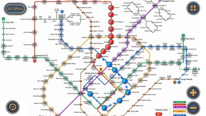
Very good but incomplete

Pilgrim21 on

Vereinigtes Königreich

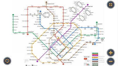
Works very well based on the data that it has but Thompson East and parts of the Circle Line, which are operational, are not included. You cannot, for instance, navigate to Gardens by the Bay.

Great Travel Support

daveg43b on

Vereinigtes Königreich

I have found this app to be extremely useful when moving around SINGAPORE on my holiday visits. Allows me to plan journeys when home in the U.K.

Rubbish

mcdazzydaz on

Vereinigtes Königreich

Rubbish Just a map Can’t search for how to get from a to b

Review

Owen786 on

Vereinigtes Königreich

Useful

Tim

ColonelSandars on

Vereinigtes Königreich

Couldn't even search for an mrt station. Not very useful..

Good app

AleCucc on

Vereinigtes Königreich

Good app

MRT APP REVIEW

Enter a Nickname One on

Singapur

Good and user friendly Great graphics and easy on the eyes. Great Value Its FREE

Very useful app!!

Hermes kuan on

Singapur

Can check distance from one station to another for all lines!

MRT Map SG

Dr. Harshad J on

Singapur

Great App

Keeps asking for review

H0nestR3viewer on

Singapur

here's your review 😐

Store-Rankings

Ranking-Verlauf
Kategorien-Rankings
Diagramm
Kategorie
Rang
Top Kostenlos
28
Top Umsatz
87
Top Kostenlos
94
Top Kostenlos
127
Top Kostenlos
161

Schlüsselwörter

Singapore MRT Map Route Konkurrenten

Name
SG NextBus
Singapore Maps
Singabus - Bus Timing + MRT
Singapore Bus Arrival Time
MyTransport.SG
Explore Singapore
Singapore MRT map
Singapore MRT LRT Offline
SG Buses - Bus Arrival Times
Singapore MRT LRT Map 2022
Singapore Metro Map & Planner
Map and Route Planner
SG Bus Timing App
Bus arrival times, fast!

Singapore MRT Map Route Installationen

Letzte 30 Tage

Singapore MRT Map Route Umsatz

Letzte 30 Tage

Singapore MRT Map Route Einnahmen und Downloads

Gewinnen Sie wertvolle Einblicke in die Leistung von Singapore MRT Map Route mit unserer Analytik.
Melden Sie sich jetzt an, um Zugriff auf Downloads, Einnahmen und mehr zu erhalten.