Singapore MRT Map Route(Pro)

Subway, Metro Transport

Veröffentlicht von: Wan Peng

Beschreibung

Aktualisiert auf die neueste Thomson-East Coast Line (TE1 Woodlands North bis BayShore) im U-Bahn-System.
Exklusiver Dunkelmodus.
Das MRT-System in Singapur wird erweitert. Bis 2030 wird das MRT-System komplexer sein, als man sich vorstellen kann. Das ist gut für alle Bewohner unserer schönen Insel, aber es wird auch ein Problem sein, weil wir nicht wissen, wie wir am schnellsten umsteigen.
Die Singapore MRT Map Route ist so konzipiert, dass Benutzer die beste Route innerhalb einer Sekunde finden können. Es wird Ihnen helfen, über die Jahre hinweg viel Zeit zu sparen.
- Aktuellste Singapur MRT-Karte anzeigen
- Zeigt die beste Route zwischen zwei Stationen an
- Berechnet automatisch die geschätzte Reisezeit
- Erfordert keine Internetverbindung.
Aktualisiert auf das neueste MRT-System:
Downtown Line(Blau)
Bukit Panjang, Cashew, Hillview, Beauty World, King Albert Park, Sixth Avenue, Tan Kah Kee, Botanic Gardens, Stevens, Newton, Little India, Rochor, Bugis, Promenade, Bayfront, Downtown, Telok Ayer, Chinatown
Circle Line(Gelb)
Dhoby Ghaut, Bras Basah, Esplanade, Promenade, Nicoll Highway[C], Stadium, Mountbatten, Dakota, Paya Lebar, MacPherson, Tai Seng, Bartley, Serangoon, Lorong Chuan, Bishan, Marymount, Caldecott, Botanic Gardens, Farrer Road, Holland Village. Buona Vista, one-north, Kent Ridge, Haw Par Villa, Pasir Panjang, Labrador Park, Telok Blangah, HarbourFront
East West Line (Grün)
Pasir Ris, Tampines, Simei, Tanah Merah, Bedok, Kembangan, Eunos, Paya Lebar, Aljunied, Kallang, Lavender, Bugis, City Hall, Raffles Place, Tanjong Pagar, Outram Park, Tiong Bahru, Redhill, Queenstown, Commonwealth, Buona Vista, Dover, Clementi, Jurong East, Chinese Garden, Lakeside, Boon Lay, Pioneer, Joo Koon, Expo,
Changi Airport
North South Line (Rot)
Jurong East, Bukit Batok, Bukit Gombak, Choa Chu Kang, Yew Tee, Kranji, Marsiling, Woodlands, Admiralty, Sembawang, Canberra, Yishun, Khatib, Yio Chu Kang, Ang Mo Kio, Bishan, Braddell, Toa Payoh, Novena, Newton, Orchard, Somerset, Dhoby Ghaut, City Hall, Raffles Place, Marina Bay, Marina South Pier
North East Line (Lila)
HarbourFront, Outram Park, Chinatown, Clarke Quay, Dhoby Ghaut, Little India, Farrer Park, Boon Keng, Potong Pasir, Woodleigh, Serangoon, Kovan, Hougang, Buangkok, Sengkang, Punggol
Ausblenden Mehr anzeigen...

Screenshots

Singapore MRT Map Route(Pro) Häufige Fragen

  • Ist Singapore MRT Map Route(Pro) kostenlos?

    Ja, Singapore MRT Map Route(Pro) ist komplett kostenlos und enthält keine In-App-Käufe oder Abonnements.

  • Ist Singapore MRT Map Route(Pro) seriös?

    🤔 Die Singapore MRT Map Route(Pro)-App scheint anständig zu sein. Es gibt Raum für Verbesserungen, aber im Allgemeinen sind die Nutzer zufrieden.

    Danke für die Stimme

  • Wie viel kostet Singapore MRT Map Route(Pro)?

    Singapore MRT Map Route(Pro) ist kostenlos.

  • Wie hoch ist der Umsatz von Singapore MRT Map Route(Pro)?

    Um geschätzte Einnahmen der Singapore MRT Map Route(Pro)-App und weitere AppStore-Einblicke zu erhalten, können Sie sich bei der AppTail Mobile Analytics Platform anmelden.

Benutzerbewertung

3 von 5

1 Bewertungen in Deutschland

5 star
0
4 star
0
3 star
1
2 star
0
1 star
0
Bewertungsverlauf

Singapore MRT Map Route(Pro) Bewertungen

Reliable

Rozitah on

Singapur

Have been using this to time my journeys and has been accurate so far. Thank you

Feedback

Jawong12345678 on

Singapur

Pls stop this pop up. Thanks

Very useful app

nameless hard to find on

Singapur

Helps a lot

MRT Pro

Sheerwin on

Singapur

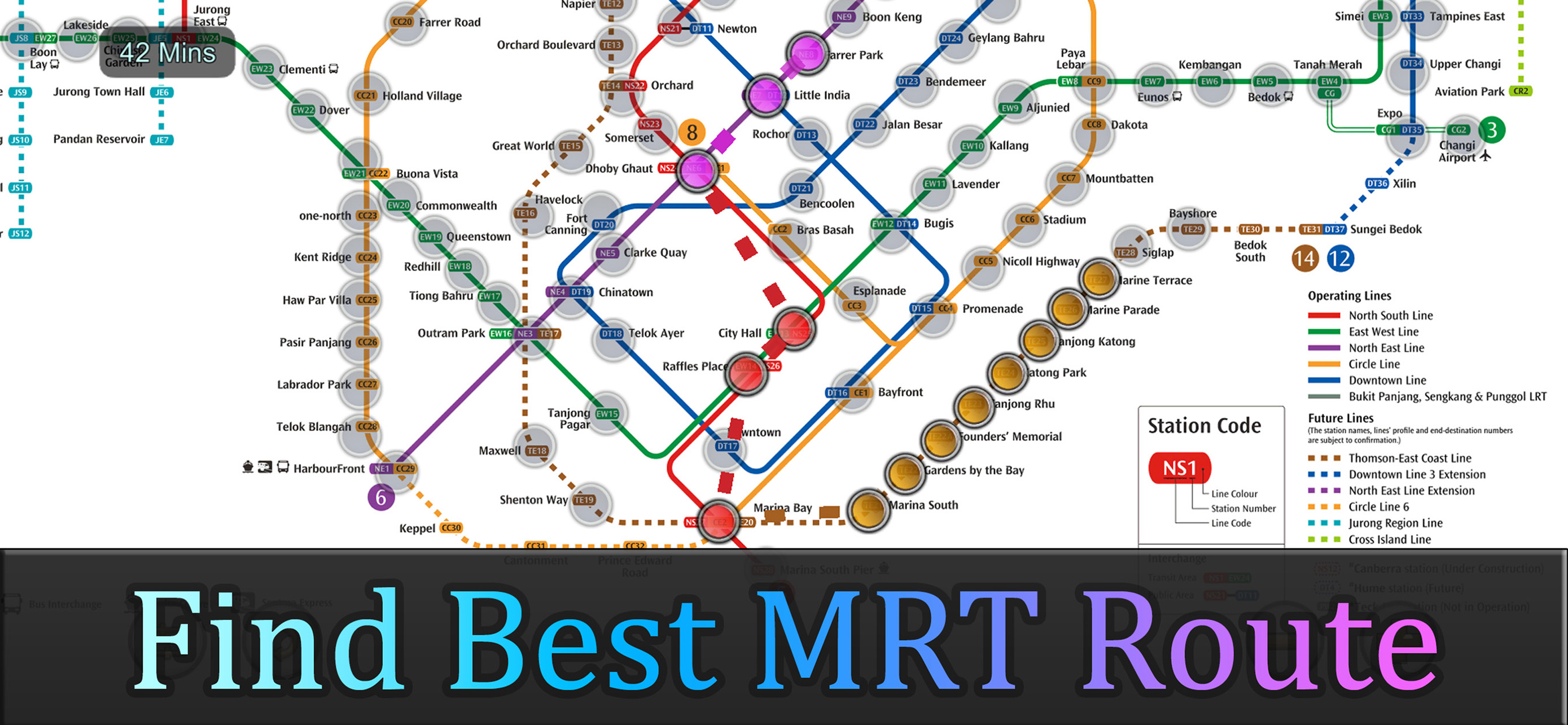
App shows travel route by MRT and time needed.

MRT pro

mea goh on

Singapur

Can make the words a little bigger

Update

Stanly49 on

Singapur

Notice the brown line still not updated.

TEL stage 4

ctckenny on

Singapur

As TEL stage 4 joins the MRT family from 23 June, hope the dotted lines will be updated and connected with the rest of the TEL on your app. Rgds, Theam

Useful app

Singapore2015 on

Singapur

Good for planning

Singapore MRT

PTeh on

Singapur

I have upgraded my app. Now, could you present the map in Chinese ? There is no language option in the settings.

To be updated

Krishramku on

Singapur

The app should be updated. Ex: Canberra station is already ready and functioning well. But the app says still under construction. Like this many incorrect info. Please go through one by one and rectify if necessary. K.R.Kumar

Store-Rankings

Ranking-Verlauf
App-Ranking-Verlauf noch nicht verfügbar
Kategorien-Rankings
Diagramm
Kategorie
Rang
Top Bezahlt
1
Top Bezahlt
11
Top Bezahlt
17
Top Umsatz
19
Top Bezahlt
24

Singapore MRT Map Route(Pro) Konkurrenten

Name
SG-BUS (Real Time)
Singapur MRT-Karte 2022
Singapore Train Route Planner
BEIDO MAP-Satellite Streetview
Satellite Maps and Streetview
Changi Airport (SIN) + Radar
SIN Live Arrivals/Departures
Train Island
Live Activities for SG MRT
Singapore MRT Train Subway
Transport SG - BUS Timing-MRT
Singapore Transit & Directions
Next Station
Navigate the MRT better
Speech Translator: Be Heard
Speak And Understand Anywhere

Singapore MRT Map Route(Pro) Installationen

Letzte 30 Tage

Singapore MRT Map Route(Pro) Umsatz

Letzte 30 Tage

Singapore MRT Map Route(Pro) Einnahmen und Downloads

Gewinnen Sie wertvolle Einblicke in die Leistung von Singapore MRT Map Route(Pro) mit unserer Analytik.
Melden Sie sich jetzt an, um Zugriff auf Downloads, Einnahmen und mehr zu erhalten.