Beschreibung
Be prepared! Plan your next trip to one of the great Texas parks. Download maps and guides before you venture into the Wi-Fi free wilderness.
Discover
- 110+ national parks, state parks, monuments, forests
- 90+ neatly folded maps by the National Park Service, Bureau of Land Management, United States Forest Services, and other agencies.
- Motor Vehicle Use Maps (MVUM), Motor Vehicle Travel Maps (MVTM) and visitor maps for Texas national forests.
- 800+ campgrounds and campsites
- 1,800+ trails and trailheads
- 130,000+ points of interests
Plan
- Download maps, park brochures, and newspapers. These downloads are ready when you are offline and off the grid in the great outdoors.
- Download arbitrary map sections as offline packs.
- Photo galleries, panorama views.
- Share links to parks and maps with friends
Have fun
- GPS and GPX support: record your hikes, import GPX routes, tracks and waypoints for your hiking trails.
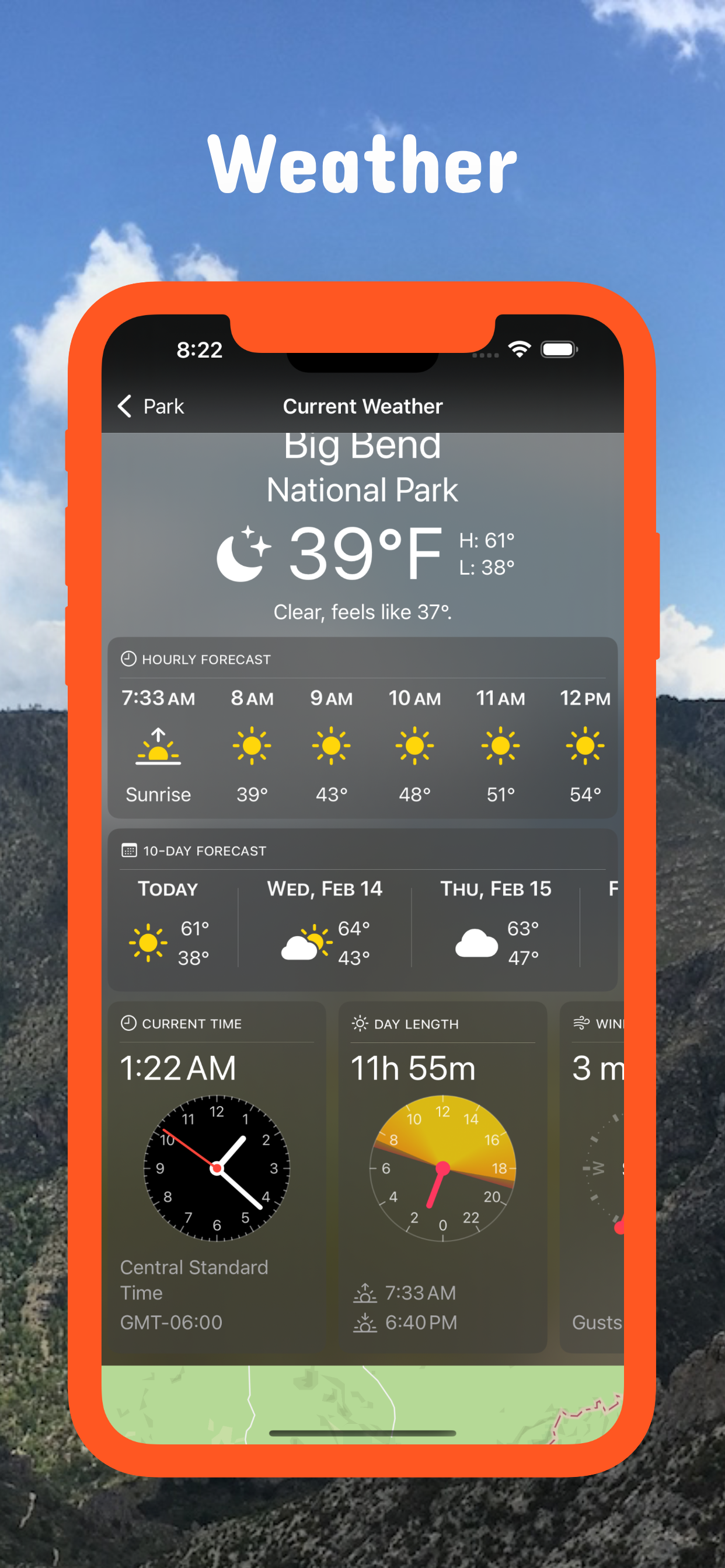
- Detailed national park information: alerts, news, visitor centers, campgrounds, driving directions, weather.
- Open your favorite maps app to get a route to the selected park.
- Current weather conditions, easy access to multi-day forecasts, sunrise and sunset times.
- Push notifications for park alerts, park news, weather warnings
So download maps and guides for:
- Abilene, Alibates Flint Quarries, Amistad, Anahuac, Angelina, Aransas, Atlanta, Attwater Prairie Chicken
- Balcones Canyonlands, Balmorhea, Bastrop, Bentsen-Rio Grande Valley, Big Bend, Big Bend Ranch, Big Bogggy, Big Spring, Big Thicket, Blanco, Bonham, Brazoria, Brazos Bend, Buescher, Buffalo Lake
- Caddo, Caddo Lake, Caprock Canyons, Carlsbad Caverns, Cedar Hill, Chamizal, Chickasaw, Choke Canyon, Cleburne, Colorado Bend, Cooper Lake, Copper Breaks
- Daingerfield, Davis Mountains, Davy Crockett, Devils River, Devil's Sinkhole, Dinosuar Valley
- Eisenhower, El Camino Real de los Tejas, El Camino Real de Tierra Dentro, Enchanted Rock, Estero Llano Grande
- Fairfield Lake, Falcon, Fort Davis, Fort Parker, Franklin Mountains
- Garner, Government Canyon, Grulla, Guadalupe Mountains
- Hagerman, Hill Country, Hueco Tanks, Huntsville
- Inks Lake
- Kickapoo Cavern
- Laguna Atascosa, Lake Bob Sandlin, Lake Brownwood, Lake Colorado City, Lake Meredith, Lake Mineral Wells, Lake Tawakoni, Lake Whitney, Longhorn Cavern, Lost Maples, Lower Rio Grande Valley, Lyndon B Johnson
- Martin Creek Lake, McFaddin, Mission Tejas, Monahans Sandhills, Muleshoe, Mustang Island
- Neches River
- Padre Island, Palo Alto Battlefield, Palo Duro Canyon, Pedernales Falls, Posssum Kingdom, President William Jefferson Clinton Birthplace Home, Purtis Creek,
- Ray Roberts Lake, Resaca de la Palma, Rio Grande
- Sabine, Sam Houston, San Angelo, San Antonio Missions, San Bernard, Santa Ana, Sea Rim, Somerville Lake, South Llano River
- Texas Point, Trinity River
- Waco Mammoth, Washita Battlefield, White Sands
Ausblenden
Mehr anzeigen...