UK Ireland Nautical Charts HD

Same detail as a Chart plotter

Veröffentlicht von: Flytomap

Beschreibung

Flytomap is a valid and interesting alternative, Benetti Yachts
Featured in : On the Deck
UK Ireland - The whole coverage resident in the app. It works WITHOUT mobile coverage!
• Worldwide Marine and Outdoor Maps available, thanks to viewer.flytomap.com
• Worldwide Satellite images overlay on charts
• Worldwide Terrain features overlay on charts, thanks to Open Street Map, Open Cycle Map, Bing,Earth,Topo Chart and GMap
• Local Marine Weather forecast
Raster and Vector charts seamless with continuous updates from the official Government server
ActiveCaptain - Worldwide boaters community, with * 200.000 + Captains
Use to Explore:
√ Latitudes and Longitudes to go to your favorite places
√ Search your Favorite points directly
√ Zoom, Rotate and Pan fast just by a finger touch
√ Quick Object information just tapping, thanks to vector technology
√ GPS Heading Vector Towards the direction movement
√ Distance Measurement Tool to easily calculate the distance from one location to another
√ Route planning, Waypoints - Insert the target/destination and see in real time your speed, distance and bearing
√ Magnified Lens for all info
√ Unlimited Tracks, Markers, Geo-tagged photos, records and share via email, visible on Google, Flytomap Viewer, KMZ format - Store your track without the need of cellular data or mobile signal
√ Select Depth Contours
√ a la carte menu
√ MOB - Man Over Board
√ Quick WP - allows you to instantly record your position and show distance and bearing
√ iOS background mode - Flytomap works in background as well, you can swap with another app and receive/make calls send sms while track recording.
√ Optimized battery usage
√ ActiveCaptain
• View and contribute to the best boaters community available in the world
• Continuous update of all info (including reviews from the deck) about :
• Marinas
• Anchorages
• Hazards
• Local Knowledge
√ Local Marine Weather forecast at a quick tap provide you:
• Day max and min temperature - Current temperature
• Significant wave height, Swell height, Swell period, Swell direction
• Tide data
• Sea temperature
• Wind Speed and direction
• Weather description
• Precipitation & Humidity
• Visibility
• Pressure
• Cloud cover in percentage
• Wind chill/Feels like Temperature
• Water Temperature
• Dew Point Temperature
• Heat Index Temperature
√ And so much more to come - It’s the only app you will ever need! Our charts are installed on: GARMIN NAVICO LOWRANCE B&G NORTHSTAR EAGLE SIMRAD
Follow us:
▶Twitter @flytomap
▶Web Site flytomap.com

▶Web App viewer.flytomap.com
▶Facebook facebook.com/flytomap

Flytomap is committed to constant improvement, this App is developed with the help of professional boaters to get the best experience on the sea, we listen to our users and systematically add the most requested features.
Thank you for the feedback!
"Continued use of GPS running in the background can dramatically decrease battery life."
Ausblenden Mehr anzeigen...

In-App-Käufe

MOB - Quick waypoint
29,00 kr

Screenshots

UK Ireland Nautical Charts HD Häufige Fragen

  • Ist UK Ireland Nautical Charts HD kostenlos?

    Nein, UK Ireland Nautical Charts HD ist nicht kostenlos (es kostet 199.00), und es enthält auch In-App-Käufe.

  • Ist UK Ireland Nautical Charts HD seriös?

    Nicht genügend Bewertungen, um eine zuverlässige Einschätzung vorzunehmen. Die App benötigt mehr Nutzerfeedback.

    Danke für die Stimme

  • Wie viel kostet UK Ireland Nautical Charts HD?

    UK Ireland Nautical Charts HD kostet 199.00 zum Herunterladen (und es gibt auch zusätzliche In-App-Käufe).

  • Wie hoch ist der Umsatz von UK Ireland Nautical Charts HD?

    Um geschätzte Einnahmen der UK Ireland Nautical Charts HD-App und weitere AppStore-Einblicke zu erhalten, können Sie sich bei der AppTail Mobile Analytics Platform anmelden.

Benutzerbewertung
Die App ist in Norwegen noch nicht bewertet.
Bewertungsverlauf

UK Ireland Nautical Charts HD Bewertungen

Don’t purchase

Adj1001 on

Vereinigtes Königreich

I got this in Dec and it didn’t work. Contacted the developers and eventually got a sort of chart working but not very good. Looked today not working again and I’m bored of having make an effort to get it working when Iv paid for it

Not good

Kallikrates55 on

Vereinigtes Königreich

Certainly not hd at all. Charts just don’t load. Asked for refund.

Very Impressed

Uncle Honk on

Vereinigtes Königreich

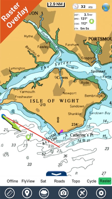
I have the current version on my IPad, compared to the Imray app and Plan to Nav, the detail on these charts is far better, unfortunately the screen updates rather slowly but as my yacht moves slowly this isn't a problem! I would like to be able to choose a slightly larger font for the depths but on the whole the charts are fantastic. It is worth having one of the alternatives as well if you want routee planning as that is something this app lacks.

No support

Wheresmeplane on

Vereinigtes Königreich

This was a great app until the last update changed the off-line map and the Flytomap button disappeared. Support has gone AWOL and can't be contacted so am left with an app that I paid for but no longer works. Should be removed from the App Store.

Store-Rankings

Ranking-Verlauf
App-Ranking-Verlauf noch nicht verfügbar
Kategorien-Rankings
Diagramm
Kategorie
Rang
Top Bezahlt
67
Top Bezahlt
260

UK Ireland Nautical Charts HD Konkurrenten

Name
StarPilot
Digital Bearing Compass
The Augmented Reality App
Lat/Long
Latitude and Longitude convert
Imray Navigator
Compass Eye Bearing Compass
Augmented Reality compass
Airports Plus
SeaNav UK & Ireland
HD Marine Navigation & Charts
NMEAremote LITE
Marine Navigation UK Ireland
Gps Nautical Charts+ Lake Maps
World Tides 2024

UK Ireland Nautical Charts HD Installationen

Letzte 30 Tage

UK Ireland Nautical Charts HD Umsatz

Letzte 30 Tage

UK Ireland Nautical Charts HD Einnahmen und Downloads

Gewinnen Sie wertvolle Einblicke in die Leistung von UK Ireland Nautical Charts HD mit unserer Analytik.
Melden Sie sich jetzt an, um Zugriff auf Downloads, Einnahmen und mehr zu erhalten.