Utah Pocket Maps

Açık Alan Rehberleri

Veröffentlicht von: Alex Gugel

Beschreibung

Be prepared! Plan your next trip to one of the great Utah parks. Download maps and guides before you venture into the Wi-Fi free wilderness.
- 120+ national parks, state parks, monuments, forests
- 180+ neatly folded maps by the National Park Service, Bureau of Land Management, United States Forest Services, and other agencies.
- Motor Vehicle Use Maps (MVUM), Motor Vehicle Travel Maps (MVTM) and visitor maps for Utah national forests.
- 4,100+ campgrounds and campsites
- 2,300+ trails and trailheads
- 41,000+ points of interests
Plan
- Download maps, park brochures, and newspapers. These downloads are ready when you are offline and off the grid in the great outdoors.
- Download arbitrary map sections as offline packs.
- Photo galleries, panorama views.
- Share links to parks and maps with friends
Have fun
- GPS and GPX support: record your hikes, import GPX routes, tracks and waypoints for your hiking trails.
- Detailed national park information: alerts, news, visitor centers, campgrounds, driving directions, weather.
- Open your favorite maps app to get a route to the selected park.
- Current weather conditions, easy access to multi-day forecasts, sunrise and sunset times.
- Push notifications for park alerts, park news, weather warnings
So download maps and guides for:
Arches
Bear Ears
Beaver Dam Wash
Bonneville Salt Flats
Bryce Canyon
Burbank Hills
Camp Floyd
Canyonlands
Canyonlands Field
7 Mile Rim Jeep Trail
Klondike Bluffs
Klonzo and Moab Brands
Labyrinth Rims
Mill Canyon Area Designated Route
Capitol Reef
Fremont River
Wayne County West
Cedar Breaks
Cedar City
Colorado Riverways
Amphitheater Loop and Fisher Towers Hiking Trails
Porcupine Rim Mountain Bike Trail
The Moab Daily
Utah Rims Designated Route Map
Conger Mountain
Crack Canyon
Cricket Mountains
Dixie
Escalante
Pine Valley
Powell
Fiddler Butte
Fishlake
Frontier Homestead
Thunderbird Canyon and Iron Hills Trails
Dinosaur
Factory Butte
Fantasy Canyon
Fishlake
Glen Canyon
North Wash
Goblin Valley
Golden Spike / Transcontinental Railroad
Gooseberry Mesa
Goosenecks
San Juan River
Grand Staircase-Escalante
Burr Trail Scenic Backway and Wolverine Loop Road
Cottonwood Road Scenic Backway
Hole-in-the-Rock Scenic Backway
Monument Travel Map
Skutumpah \/ Johnson Canyon Roads
Green River
Gunlock
Horseshoe Canyon (South)
Kanab
Kodachrome Basin
Little Saharah
Manti-La Sal
Millsite
Sevier County
Moab
Amasa Back Area Mountain Bike Trails
BLM Moab Camping
Chicken Corners Jeep Trail
Gemini Bridges and Long Canyon
Poison Spider Mesa
Slickrock Bike Trail
Steel Bender Jeep Safari Route
Monticello Travel Plans
Moonshine Arch
Mount Pennell
Henry Mountains
Natural Bridges
Otter Creek
Palisade
Piute County
Pony Express Trail
Price
Red Cliffs
Red Fleet
Robber Roost
San Rafael Swell
Sand Hollow
Sanpete
Salt Lake City
Sawtooth
Sevier
Smithsonian Butte National Back Country Byway
Snow Canyon
Territorial Statehouse
Three Peaks
Valley of the Gods
Vernal
McCoy Flats
Moonshine Arch
West Wayne
Zion
There are additional useful information and brochures for many Utah state parks.
LEGAL
Terms of Use: https://icoat.de/pocketmaps/terms
Privacy Policy: https://icoat.de/pocketmaps/privacy
Ausblenden Mehr anzeigen...

In-App-Käufe

access all pro features
₺48,99

Screenshots

Utah Pocket Maps Häufige Fragen

  • Ist Utah Pocket Maps kostenlos?

    Ja, Utah Pocket Maps ist kostenlos herunterzuladen, enthält jedoch In-App-Käufe oder Abonnements.

  • Ist Utah Pocket Maps seriös?

    Nicht genügend Bewertungen, um eine zuverlässige Einschätzung vorzunehmen. Die App benötigt mehr Nutzerfeedback.

    Danke für die Stimme

  • Wie viel kostet Utah Pocket Maps?

    Utah Pocket Maps bietet mehrere In-App-Käufe/Abonnements, der durchschnittliche In-App-Preis beträgt 48.99 ₺.

  • Wie hoch ist der Umsatz von Utah Pocket Maps?

    Um geschätzte Einnahmen der Utah Pocket Maps-App und weitere AppStore-Einblicke zu erhalten, können Sie sich bei der AppTail Mobile Analytics Platform anmelden.

Benutzerbewertung
Die App ist in Türkei noch nicht bewertet.
Bewertungsverlauf

Utah Pocket Maps Bewertungen

Unbelievable

WT impossible on

Vereinigte Staaten

There’s a nag screen with every move. It’s relentless. I give 2 stars because it does work but the nag screens are wayyy past annoying.

Worth paying for

xgh on

Vereinigte Staaten

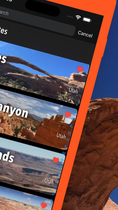
This series of maps and info packets is well done. The issue with the app is organization. Different States require different apps rather than simply adding it to the main app. As a result, I have a good case of app litter most times I use this app. The second issue is, within the app, there is no way to switch from one park (within a State) to another without going to search. Which means you have to remember the names of what you've downloaded. As well as the name of where you might want to consider as a next stop. There is a listing of large banners that can be flipped through to select a park. However, it’s not always in alphabetic order and it’s a really lousy substitute for a simple table of contents. Not to mention flipping through endless banners in States with lot's of parks. Hopefully the developer will streamline the app as it’s pretty good but too frustrating to use at times.

Amazing app for travel!

SueBrideshead on

Vereinigte Staaten

We recently went to southern Utah for spring break, and I subscribed to a short period on this app, and it was the best $2 of preparation for the trip ever. Because we were driving through canyon country, where cell and internet service were severely limited, the ability to download maps was vital for planning a trip that had to include flexibility. The ability to sit in a restaurant in small-town Utah and figure out where to camp, and be able to download the brochure and information for an entire area was amazing, and we ended up visiting four state parks we might not have otherwise known about, and camping at a gorgeous, primitive camping location on a lake along the way. The availability of OHV, Forest Service, BLM, and other land management agency maps on this app will ensure that I will be recommending it (and other states versions) to others and although I might never use the Utah version again, I’m sure that I will use another state soon - maybe for another impromptu summer vacation!

Store-Rankings

Ranking-Verlauf
App-Ranking-Verlauf noch nicht verfügbar
Kategorien-Rankings
App ist noch nicht gerankt

Utah Pocket Maps Konkurrenten

Name
Greater Zion
NP Maps
National Park & Topos maps USA
Canyonlands Audio Tour Guide
Moab - Utah - Arches - Hiking
Parks Seeker
Exploring U.S. National Parks
National Park Kiosk
A Guide to the National Parks
Arches & Utah Parks Audio Tour
Delicate Arch Audio Tour Guide
Grand Canyon NP Audio Guide
Grand Canyon South Rim Tours
Zion & Bryce Canyon Utah Guide
Utah National Park Audio Guide
Bryce Canyon Audio Tour Guide
Utah National Parks - Mighty 5
Utah's Trail Country

Utah Pocket Maps Installationen

Letzte 30 Tage

Utah Pocket Maps Umsatz

Letzte 30 Tage

Utah Pocket Maps Einnahmen und Downloads

Gewinnen Sie wertvolle Einblicke in die Leistung von Utah Pocket Maps mit unserer Analytik.
Melden Sie sich jetzt an, um Zugriff auf Downloads, Einnahmen und mehr zu erhalten.

App-Informationen

Kategorie
Travel
Herausgeber
Alex Gugel
Sprachen
Catalan, Croatian, Czech, Danish, Dutch, English, Finnish, French, German, Greek (modern), Hindi, Hungarian, Indonesian, Italian, Japanese, Korean, Malay, Norwegian Bokmål, Polish, Portuguese, Romanian, Russian, Slovak, Spanish, Swedish, Thai, Chinese, Turkish
Letzte Veröffentlichung
6.7 (vor 1 Monat )
Veröffentlicht am
Oct 7, 2017 (vor 7 Jahren )
Zuletzt aktualisiert
vor 1 Monat