
Downloads
Umsatz
Beschreibung
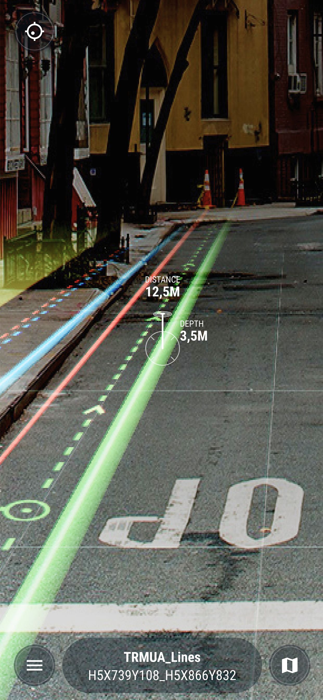
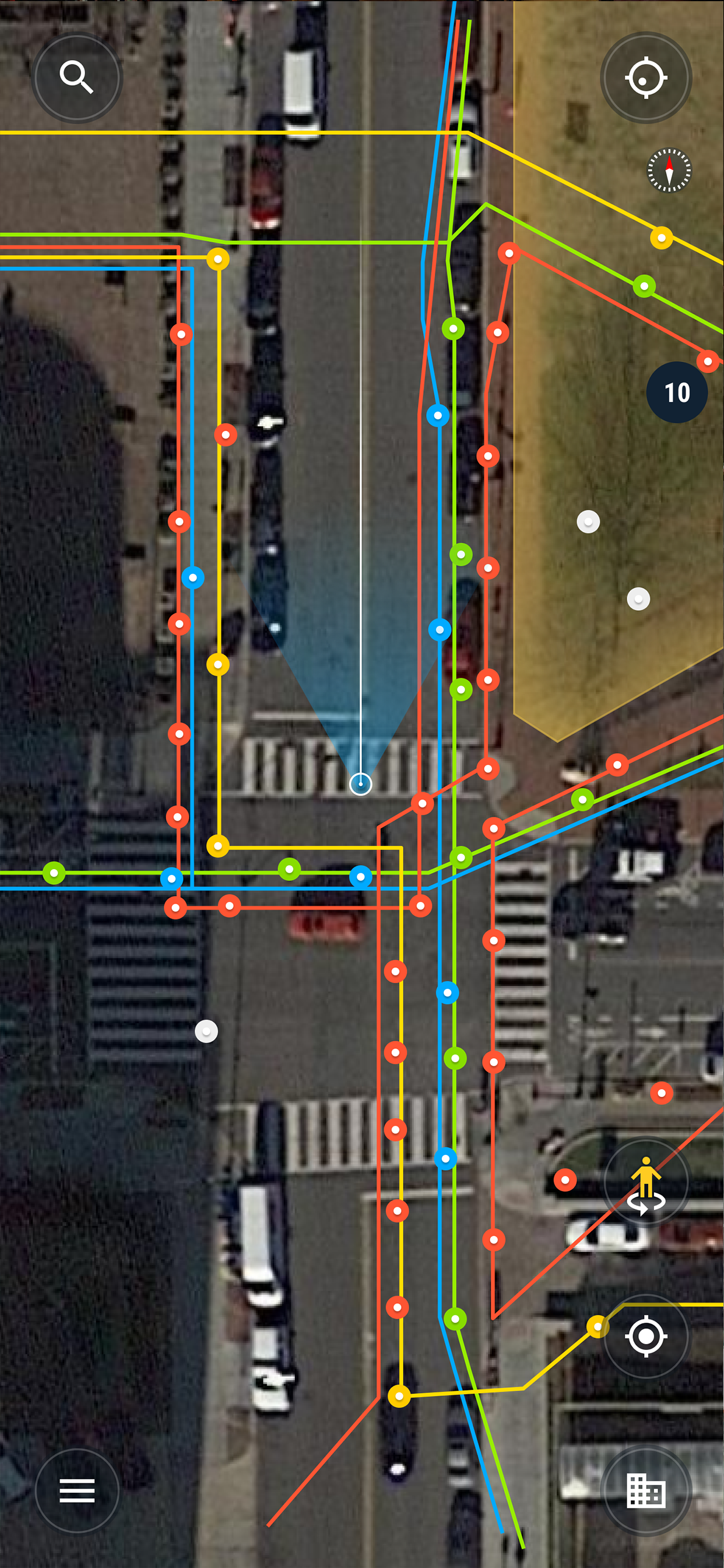
Using the vGIS system, field personnel can see an augmented view that includes holographic infrastructure objects, improving their environmental assessments and increasing their situational awareness. From delivering real-time, in-field holographic visualizations of underground pipes, valves, cables and other utility objects to visualizing ground penetrating radar scans, vGIS solutions are estimated to prevent 25% of excavation-related accidents resulting from human error, among other benefits.
The system combines object holograms with object-specific data to provide a hands-free method for field technicians to understand the infrastructure they need to service while on site, quickly and safely.
Key features:
• Exceptional Accuracy
• Consistent Visualizations: 3D overlays stay “world-locked” by remaining in sync with the physical world
• Multi-Device Support
• No Additional Equipment: vGIS Utilities does not require any additional equipment
• Workflow Integration: vGIS Utilities integrates with your existing back-office systems
• Advanced Collaboration: Integrated holograms, video, and audio that connect the office with field teams
• Format Support: Esri Feature Services, Esri Map Services, Esri Scene Services, Esri Building Services, Bentley iTwin, WFS, WMS, WMTS, GeoJSON, KML
• GNSS Integration: Leica GG04 plus, EOS Arrow Series, SXBlue, TopCon and Trimble R series/Catalyst
• Multi-View Support: First-person on-site experience and birds-eye “zoom out” site overviews
Ausblenden
Mehr anzeigen...
The system combines object holograms with object-specific data to provide a hands-free method for field technicians to understand the infrastructure they need to service while on site, quickly and safely.
Key features:
• Exceptional Accuracy
• Consistent Visualizations: 3D overlays stay “world-locked” by remaining in sync with the physical world
• Multi-Device Support
• No Additional Equipment: vGIS Utilities does not require any additional equipment
• Workflow Integration: vGIS Utilities integrates with your existing back-office systems
• Advanced Collaboration: Integrated holograms, video, and audio that connect the office with field teams
• Format Support: Esri Feature Services, Esri Map Services, Esri Scene Services, Esri Building Services, Bentley iTwin, WFS, WMS, WMTS, GeoJSON, KML
• GNSS Integration: Leica GG04 plus, EOS Arrow Series, SXBlue, TopCon and Trimble R series/Catalyst
• Multi-View Support: First-person on-site experience and birds-eye “zoom out” site overviews
Screenshots


vGIS AR Häufige Fragen
-
Ist vGIS AR kostenlos?
Ja, vGIS AR ist komplett kostenlos und enthält keine In-App-Käufe oder Abonnements.
-
Ist vGIS AR seriös?
Nicht genügend Bewertungen, um eine zuverlässige Einschätzung vorzunehmen. Die App benötigt mehr Nutzerfeedback.
Danke für die Stimme -
Wie viel kostet vGIS AR?
vGIS AR ist kostenlos.
-
Wie hoch ist der Umsatz von vGIS AR?
Um geschätzte Einnahmen der vGIS AR-App und weitere AppStore-Einblicke zu erhalten, können Sie sich bei der AppTail Mobile Analytics Platform anmelden.

Benutzerbewertung
Die App ist in Irland noch nicht bewertet.
Bewertungsverlauf
vGIS AR Bewertungen
Keine Bewertungen in Irland
Die App hat noch keine Bewertungen in Irland.
Store-Rankings
Ranking-Verlauf
App-Ranking-Verlauf noch nicht verfügbar
Kategorien-Rankings
App ist noch nicht gerankt
vGIS AR Konkurrenten
| Name | Downloads (30d) | Monatlicher Umsatz | Rezensionen | Bewertungen | Letzte Veröffentlichung | |
|---|---|---|---|---|---|---|

GAMMA AR
AR + BIM for Construction & FM
|
Freischalten
|
Freischalten
|
0
|
|
vor 1 Woche | |

VisualLive
AR solution for AEC and BIM
|
Freischalten
|
Freischalten
|
0
|
|
vor 1 Jahr | |

The Argis® Lens
Augmented Reality for GIS
|
Freischalten
|
Freischalten
|
0
|
|
vor 1 Jahr | |

ArcGIS Indoors
An Indoor Mapping System
|
Freischalten
|
Freischalten
|
0
|
|
vor 2 Monaten | |
|
SYNCHRO Field
|
Freischalten
|
Freischalten
|
0
|
|
vor 6 Tagen | |

Augview
AR for Asset Management
|
Freischalten
|
Freischalten
|
0
|
|
vor 2 Wochen | |

Esri Support
AI enabled support for ArcGIS
|
Freischalten
|
Freischalten
|
0
|
|
vor 2 Wochen | |

Trimble Connect AR
AR Visualization for AEC
|
Freischalten
|
Freischalten
|
0
|
|
vor 1 Monat | |

Trimble SiteVision
N/V
|
Freischalten
|
Freischalten
|
0
|
|
vor 1 Monat | |

Touch GIS
Advanced field data collection
|
Freischalten
|
Freischalten
|
0
|
|
vor 2 Wochen |
vGIS AR Installationen
Letzte 30 Tage
vGIS AR Umsatz
Letzte 30 TagevGIS AR Einnahmen und Downloads
Gewinnen Sie wertvolle Einblicke in die Leistung von vGIS AR mit unserer Analytik.
Melden Sie sich jetzt an, um Zugriff auf Downloads, Einnahmen und mehr zu erhalten.
Melden Sie sich jetzt an, um Zugriff auf Downloads, Einnahmen und mehr zu erhalten.
App-Informationen
- Kategorie
- Productivity
- Herausgeber
- vGIS
- Sprachen
- Dutch, English, French, German, Italian, Japanese, Korean, Norwegian Bokmål, Portuguese, Russian, Spanish, Swedish
- Letzte Veröffentlichung
- 3.38.0 (vor 2 Wochen )
- Veröffentlicht am
- Jan 18, 2018 (vor 6 Jahren )
- Auch verfügbar in
- Vereinigte Staaten, Kanada, Japan, Vereinigtes Königreich, Niederlande, Ukraine, Polen, Philippinen, Singapur, Australien, Neuseeland, Südafrika, Südkorea, Kuwait, Kasachstan, Libanon, Mexiko, Malaysia, Nigeria, Vietnam, Norwegen, Thailand, Peru, Taiwan, Pakistan, Indien, Portugal, Rumänien, Russland, Saudi-Arabien, Schweden, Türkei, Dominikanische Republik, Argentinien, Österreich, Aserbaidschan, Belgien, Brasilien, Belarus, Schweiz, Chile, China, Kolumbien, Tschechien, Deutschland, Dänemark, Italien, Algerien, Ecuador, Ägypten, Spanien, Finnland, Frankreich, Griechenland, Sonderverwaltungsregion Hongkong, Ungarn, Indonesien, Irland, Israel, Vereinigte Arabische Emirate
- Zuletzt aktualisiert
- vor 1 Monat
- © 2024 AppTail.
- Unterstützung
- Privacy
- Terms
- All Apps