VT Trails

Veröffentlicht von: Tyler Elko

Beschreibung

VT Trails is built to take you to and from the most scenic vistas in Vermont with style and confidence. This app boasts statewide USGS topographic maps, over 2,000 labeled hiking, walking and biking trails and a high accuracy track of Vermont's Long Trail with 600+ points of interest gathered by through hikers.
Statewide USGS topographic maps are stored on your device, so go ahead and turn on airplane mode to extend battery life and boot up the GPS only when you need it to pinpoint your location.
The convenient mileage menu calculates distance between any two points on the map and integrates with an interactive profile graph of the Long Trail to show elevation gain/loss over Vermont’s highest peaks.

Detailed List of Features:
Statewide:
-Statewide USGS topographic maps stored on your phone. No cell coverage needed!
-Over 2,000 labeled hiking, walking and biking trails.
-A mileage calculator for trip planning.
-Place search powered by Google.
Long Trail Focused:
-A highly detailed track of Vermont's longest hiking trail.
-Super high detail USGS topographic maps (1:24,000 scale) flanking the trail.
-A trail mileage and elevation calculator.
-Shelters, official and unofficial, with descriptive photos.
-An interactive profile view showing elevation, trail intersections and points of interest.
-100+ water sources categorized as rivers, streams and ponds.
-Hundreds more waypoints including: tent sights, views, fire pits, parking, summits, towers and gaps.

A selection of over 50 major side trails accessing the LT can be added to the map with the flick of a switch, guiding you with ease to the most scenic locations in Vermont.
Any stream near the LT and big enough to wedge the mouth of your water bottle into has been marked to keep through hikers informed and hydrated.
65 trailside shelters, ski lodges and shacks have been included with descriptive photos and shelters subject to midsummer fees are labeled as such.
Ausblenden Mehr anzeigen...

Screenshots

VT Trails Häufige Fragen

  • Ist VT Trails kostenlos?

    Ja, VT Trails ist komplett kostenlos und enthält keine In-App-Käufe oder Abonnements.

  • Ist VT Trails seriös?

    Nicht genügend Bewertungen, um eine zuverlässige Einschätzung vorzunehmen. Die App benötigt mehr Nutzerfeedback.

    Danke für die Stimme

  • Wie viel kostet VT Trails?

    VT Trails ist kostenlos.

  • Wie hoch ist der Umsatz von VT Trails?

    Um geschätzte Einnahmen der VT Trails-App und weitere AppStore-Einblicke zu erhalten, können Sie sich bei der AppTail Mobile Analytics Platform anmelden.

Benutzerbewertung
Die App ist in Schweden noch nicht bewertet.
Bewertungsverlauf

VT Trails Bewertungen

Useful long trail app

NH Ed on

Vereinigte Staaten

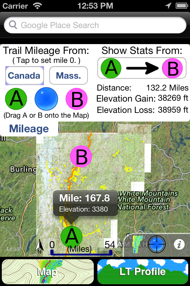
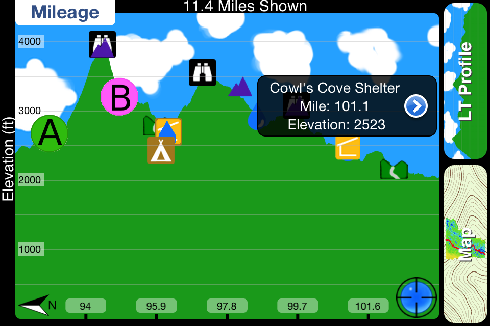
I am an avid backpacker here in NH and decided to section hike the long trail. The map that places like EMS sells does not have enough detail in my opinion, so I picked up this app as a supplement to my map. The maps are large downloads, but necessary since cell service is sketchy at best on trail. The app works great without any issues thus far. I really like its ability to calculate distances and elevation gains and losses by dropping two markers. I found this very useful when I had been hiking for a while and I wanted to know exactly what distance was left to the shelter or summit, etc... Battery life is still the biggest issue with using the iPhone on trail, however, if you take it in and out of airplane mode as you use it your battery should easily last 5 days.

Store-Rankings

Ranking-Verlauf
App-Ranking-Verlauf noch nicht verfügbar
Kategorien-Rankings
App ist noch nicht gerankt

VT Trails Konkurrenten

Name
Brattleboro
The most storied small town.
The A.T. Guide
Official Awol Guide PDF App
Big Hike
Essential Hiking Companion
Visit New England
Timeless Authentic Nearby
Route3D 3.0
Topo map navigation
Vermont Road Report
Vermont road conditions
Kancamagus Byway: GPS Guide
Self-Guided Audio Scenic Tour
Ghosts of Savannah Tour Guide
Self-Guided GPS Audio Tours
CartoLake - Map Studio
Map Viewer and Authoring Tool
Middlebury Ski & Golf

VT Trails Installationen

Letzte 30 Tage

VT Trails Umsatz

Letzte 30 Tage

VT Trails Einnahmen und Downloads

Gewinnen Sie wertvolle Einblicke in die Leistung von VT Trails mit unserer Analytik.
Melden Sie sich jetzt an, um Zugriff auf Downloads, Einnahmen und mehr zu erhalten.